more stats
2,188 ft
Distance
-196 ft
Descent
00:01:30
Avg time
-198 ft
Altitude change
1,441 ft
Altitude min
1,639 ft
Altitude max
1,639 ft
Altitude start
1,440 ft
Altitude end
-9%
Grade
-26.6%
Grade max
-0.9%
Grade min
1,978 ft
Distance down
177 ft
Distance flat
00:01:30
Avg time

Snakebite Details

  • Activities
    • Mountain Bike
  • Riding Area
    Bryce Bike Park
    Basye, Virginia
  • Difficulty Rating
  • Voted Difficulty
    Blue (1 vote)
  • Local Popularity
    55 in Mountain Biking
  • Global Ranking
    #37233 in Mountain Biking
  • Trail Type
    Singletrack
  • Bike Type
    DH, AM, XC
  • Direction
    Downhill Only
    Popular Direction Shown
  • Trail Visibility
    Always easy to follow
  • TTFs on Trail
    Berm, Jump, Skinny
  • Land Owner

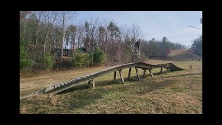
Snakebite is a tight and narrow trail that hugs the left side of Brew Thru. The main attraction for most folks is probably the wooden skinny.

Access Info

Take Screwdriver and stay right at the first left hand berm

Bike Park

Traditionally Indigenous Territory

Recent Activity on Trail

Past Week
  • 6 rides
  • 13 miles average
6 Months
  • 26 rides
  • 14 miles avg distance
All
  • 299 rides
  • Last: Jun 7, 2026
c1c2c3c4
January
February
March
April
May
June
July
August
September
October
November
December
update trails status or condition

Snakebite Trail Reports

statusdatedescription
Nov 16, 2025 @ 10:40am (America/New_York)
Nov 16, 2025
Nov 15, 2025 @ 10:13am (America/New_York)
Nov 15, 2025
Nov 14, 2025 @ 12:12pm (America/New_York)
Nov 14, 2025
Decent leaf cover hiding those roots in the woods.
May 11, 2025 @ 8:56am
May 11, 2025
Oct 9, 2024 @ 11:54am
Oct 9, 2024
Running pretty good but is getting pretty beat from the season worth of riding on it.
more »
Status:
on Nov 16, 2025
Dry
Avg: 4.05 (11 votes)
Your vote: 0

view (2,838)
close
3D
Trail Conditions
  • Unknown
  • Snow Groomed
  • Snow Packed
  • Snow Covered
  • Snow Cover Partial
  • Freeze/thaw Cycle
  • Icy
  • Prevalent Mud
  • Wet
  • Variable
  • Ideal
  • Dry
  • Very Dry
Trail Flow (Ridden Direction)
Trailforks scans users ridelogs to determine the most popular direction each trail is ridden. A good flowing trail network will have most trails flowing in a single direction according to their intension.
The colour categories are based on what percentage of riders are riding a trail in its intended direction.
  • > 96%
  • > 90%
  • > 80%
  • > 70%
  • > 50%
  • < 50%
  • bi-directional trail
  • no data
Trail Last Ridden
Trailforks scans ridelogs to determine the last time a trail was ridden.
  • < 2 days
  • < 1 week
  • < 2 weeks
  • < 1 month
  • < 6 months
  • > 6 months
Trail Ridden Direction
The intended direction a trail should be ridden.
  • Downhill Only
  • Downhill Primary
  • Both Directions
  • Uphill Primary
  • Uphill Only
  • One Direction
Contribute Details
Colors indicate trail is missing specified detail.
  • Description
  • Photos
  • Description & Photos
  • Videos
Trail Popularity ?
Trailforks scans ridelogs to determine which trails are ridden the most in the last 9 months. Trails are compared with nearby trails in the same city region with a possible 25 colour shades. Think of this as a heatmap, more rides = more kinetic energy = warmer colors.
  • most popular
  • popular
  • less popular
  • not popular
ATV/ORV/OHV Filter
Max Vehicle Width
inches
US Cell Coverage
Legend
cell carrier legend

Radar Time
Activity Recordings
Trailforks uses anonymized public activity data. ?
Activity Recordings
Trailforks uses anonymized public activity data. ?
Personal Heatmap
Activity Types
all / none
Options
2
Date range month
Winter Trails
Warning A routing network for winter maps does not exist. Selecting trails using the winter trails layer has been disabled.
Missing Trails
Most Popular
Least Popular
Trails are colored based on popularity. The more popular a trail is, the more red. Less popular trails trend towards green.
Jump Magnitude Heatmap
Heatmap of where riders jump on trails. Zoom in to see individual jumps, click circles to view jump details.
BC Backroad Status

Service Road Atlas is a free to use, community-driven service for viewing and creating reports on the numerous back-country service roads around B.C. and Alberta.

map legend
Slope Aspect
Direction the slope faces
Flat N NE E SE S SW W NW
Trails Deemphasized
Trails are shown in grey.
disable
Only show trails with no bike usage.
Enable
Suggested Layers
Based on selected activity type

    Save the current map location and zoom level as your default home location whenever this page is loaded.

    Save
        Directions to snakebite trailhead (38.810820, -78.767410)

        Photos

        No photos have been added for Snakebite yet, add a photo.

        Videos

        12 more »
        APRocks rides Snake Brew Bomb end of season
        3:26 | 28 | Nov 11, 2025 , Basye
        I Refuse to Quit... Epic crash and recovery at...
        4:16 | 42 | Aug 13, 2025 , Basye
        I Refuse to Quit... Epic crash and recovery at...
        4:16 | 50 | Jun 26, 2025 , Basye
        DOWN DURO 5 WINNING RUN - The Trash Can |GoPro...
        4:19 | 89 | Nov 15, 2024 , Basye

        Reviews / Comments

        No reviews yet, be the first to write a review or ask a question.
        Use trail reports to comment on trail conditions.


        We hope you've been enjoying Trailforks!

        Create a FREE account to view trail comments and much more.

        Frequently Asked Questions About Snakebite

        Where is Snakebite located?
        Snakebite is located in Bryce Bike Park, Basye, Virginia, United States. It is part of the Bryce Bike Park trail network. The trailhead is located at coordinates 38.81082, -78.76741.
        How hard is Snakebite?
        Snakebite is rated as Blue difficulty. The average grade is 9%.
        What is the elevation gain for Snakebite?
        The trail has 196 ft of elevation descent. The elevation ranges from 1,441 ft to 1,639 ft.
        Is Snakebite a point to point trail?
        Yes, Snakebite is a point to point trail. The direction is Downhill Only. The trail type is singletrack.

        Hit the Trail

        Open in App

        Get this trail on your phone instantly.
        open trail in app

        Download Trail

        Save to wishlist, Garmin & download.
        save the trail

        Find Related Routes

        Find routes and users activities that include this trail.
        find routes for this trail

        You must enter a description before submitting.