

Open in App
Get this trail on your phone instantly.

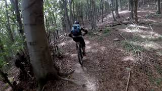
This trail takes its name from the second world war trenches that were built and used in the area the trail passes. This is a great example of a flow experience starting from Din: after around five minutes of pedaling uphill on an easy double track, the trail starts with a few corners in the woods before riding straight down a small open valley. It, then, continues on a carpet of leaves before crossing the road and keeping going on the south side of the mountain. It ends on a grave road that allows to climb back to Din.
Din Area is reachable from the E80 highway accessing Finale Ligure, then drive north on the SP490 until the openings at the crossroad towards Osiglia.
Pay attention at the road crossing. Given its nature, the trail can change after weather happenings and season changes. Always pay attention.

| c1 | c2 | c3 | c4 |
|---|---|---|---|
January | February | March | April |
May | June | July | August |
September | October | November | December |

Service Road Atlas is a free to use, community-driven service for viewing and creating reports on the numerous back-country service roads around B.C. and Alberta.
Save the current map location and zoom level as your default home location whenever this page is loaded.
SaveWe hope you've been enjoying Trailforks!
Create a FREE account to view all trail reviews and much more.
You must enter a description before submitting.

