
more stats
4.0 miles
Distance
1,563 ft
Climb
-49 ft
Descent
00:16:29
Avg time
1,513 ft
Altitude change
4,461 ft
Altitude min
5,974 ft
Altitude max
4,461 ft
Altitude start
5,974 ft
Altitude end
7.1%
Grade
-11.4%
Grade max
49.9%
Grade min
3 miles
Distance climb
2,405 ft
Distance down
1,145 ft
Distance flat
00:16:29
Avg time

Uphill Flow Trail Details

  • Activities
    • Mountain Bike
    • E-Bike
    • Gravel Bike
    • Adaptive Bike
  • Riding Area
    Bikepark Schladming
    Schladming
  • Difficulty Rating
  • Local Popularity
    25 in Mountain Biking heatmap [+]
    • 45 in E-Biking
    • 5 in Adaptive Biking
    • 5 in Gravel Biking
  • Trail Type
    Machine Groomed
  • Bike Type
    AM, XC, Gravel, Adaptive MTB
  • Direction
    Uphill Only
    Popular Direction Shown
  • Climb Difficulty
    Blue
  • Physical Rating
    Moderate
  • Trail Visibility
    Always easy to follow
  • eBike Allowed
    Yes up to Class 1
  • TTFs on Trail
    Berm, Bridge
  • Year Opened
    2020

Uphill trail at Bikepark Schladming from the gondola's middle to top station.

Tags
BermsBridgesFlowy

Bike Park

Recent Activity on Trail

Past Week
  • 0 rides
  •  
6 Months
  • 12 rides
  • 20 miles avg distance
All
  • 38 rides
  • Last: Jun 14, 2023
c1c2c3c4
January
February
March
April
May
June
July
August
September
October
November
December
update trails status or condition

Uphill Flow Trail Trail Reports

statusdatedescription
Jan 6, 2026 @ 7:16pm (Europe/Vienna)
Jan 6, 2026
Gesperrt. Skisaison jetzt. Vorraussichtliche Öffnung des Bikeparks laut aktuellem Stand am 14.Mai 2026
Jan 6, 2026 @ 7:16pm (Europe/Vienna)
Jan 6, 2026
Gesperrt. Skisaison jetzt. Vorraussichtliche Öffnung des Bikeparks laut aktuellem Stand am 14.Mai 2026
Oct 30, 2022 @ 1:54am
Oct 30, 2022
Oct 8, 2022 @ 6:50pm
Oct 8, 2022
Jun 23, 2022 @ 4:06am
Jun 23, 2022
OK for EMTB, less for MTB.
more »
Status:
on Jan 6, 2026
Avg: 3.65 (3 votes)
Your vote: 0

view (397)
close
      Directions to uphill-flow-trail trailhead (47.382730, 13.709190)

      Photos

      No photos have been added for Uphill Flow Trail yet, add a photo.

      Videos

      1 more »
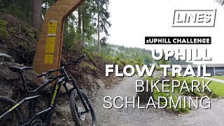
      youtuber elektroUphill Challenge - Bikepark Schladming...
      mtb
      2:12 | 638 | Jul 20, 2020 , Schladming
      3.0 ★★★★★
      3 Ratings
      5 ★
      4 ★ 67%
      3 ★
      2 ★
      1 ★ 33%

      1 Review & Comments

      ktm-boy-69 ktm-boy-69
      Ohne Motor auch sehr okay zu pedalieren. Zaht sich halt ein wenig. Weniger erfreulich sind die aktuell doch nicht so kurzen Zwischenstücke die man nur auf einer Forststraße anstatt eines Trails fährt, bzw. wo man im Mittelteil einfach in der Spur hinauffährt, wo die Flow-Line herunter kommt ...

      Achtung: Die Benützung des (teilweise-) Trails kostet 7€ – direkt beim Traileingang steht dazu auch ein Parkscheinautomat zum Maut kassieren. Uphill auf der normalen Maut-Forststraße von der Mittelstation zur Bergstation ist gratis.

      We hope you've been enjoying Trailforks!

      Create a FREE account to view all trail reviews and much more.

      • By linesTF Pro TRAILFORKS & contributors
      • #308950 - 1,206 views

      Frequently Asked Questions

      ▼ Where is Uphill Flow Trail located?
      Uphill Flow Trail is located in Bikepark Schladming, Schladming, Austria. It is part of the Bikepark Schladming trail network. The trailhead is located at coordinates 47.38273, 13.70919.
      ▼ What is the elevation gain for Uphill Flow Trail?
      Uphill Flow Trail has 1,563 ft of elevation gain. The trail has 49 ft of elevation descent. The elevation ranges from 4,461 ft to 5,974 ft.
      ▼ Is Uphill Flow Trail a point to point trail?
      Yes, Uphill Flow Trail is a point to point trail. The direction is Uphill Only. The trail type is machine groomed.
      ▼ How long is Uphill Flow Trail?
      Uphill Flow Trail is 4.0 miles long. The trail type is machine groomed.
      ▼ Are dogs allowed on Uphill Flow Trail?
      There is no information about dogs being allowed on Uphill Flow Trail. Check with local trail managers or the trail page for the latest access rules.
      ▼ When is the best time of year to ride Uphill Flow Trail?
      Based on activity log data, the most popular months to ride Uphill Flow Trail are:
      • August (11 activities)
      • June (8 activities)
      • September (5 activities)
      Check the reports page for current trail conditions.
      ▼ How do I access Uphill Flow Trail? Where is the closest parking trailhead?
      The closest parking and trailhead locations to Uphill Flow Trail are: View all parking locations in the area.
      ▼ How long does it take to ride Uphill Flow Trail?
      Based on recorded activities, it takes an average of 16 minutes to ride Uphill Flow Trail. The trail is 4.0 miles long. Actual times will vary based on fitness level, conditions, and pace. View recent activity logs for more details.
      ▼ How busy is Uphill Flow Trail?
      Uphill Flow Trail is a less popular trail with lighter traffic. There have been 172 recorded activities on this trail. The trail has received 397 check-ins. View recent activity on this trail.

      Hit the Trail

      Open in App

      Get this trail on your phone instantly.

      open trail in app

      Download Trail

      Save to wishlist, Garmin & download.
      save the trail

      Find Related Routes

      Find routes and users activities that include this trail.
      find routes for this trail

      You must enter a description before submitting.

