
This trail is permanently closed/decommissioned
more stats
3,602 ft
Distance
3 ft
Climb
-481 ft
Descent
00:14:25
Avg time
-478 ft
Altitude change
1,218 ft
Altitude min
1,696 ft
Altitude max
1,696 ft
Altitude start
1,217 ft
Altitude end
-13.3%
Grade
-49.1%
Grade max
4.4%
Grade min
39 ft
Distance climb
3,471 ft
Distance down
92 ft
Distance flat
00:14:25
Avg time

Upper Happy Hour Details

  • Activities
    • Mountain Bike
    • E-Bike
    • Hike
    • Trail Running
  • Difficulty Rating
  • Local Popularity
    70 in Mountain Biking heatmap [+]
    • 85 in E-Biking
    • 5 in Trail Running
    • 5 in Hiking
  • Trail Type
    Singletrack
  • Bike Type
    DH, AM
  • Direction
    Downhill Primary
    Popular Direction Shown
  • Climb Difficulty
    Double Black Diamond
  • Physical Rating
    Hard
  • Trail Visibility
    Sometimes hard to follow
  • eBike Allowed
  • TTFs on Trail
    Drop, Jump, Rock Face, Rock Garden
  • Year Opened
    2011
  • Land Owner
    Pennsylvania Department of Conservation and Natural Resources

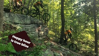
A fun and rewarding trail. Classic Michaux riding. Starts with a few drops into a small fielded section, then leads into the forest through some tight trees and switchbacks. From there there is an optional drop (4ft to flat) to a small jump. More bench cut singletrack to a super fun multi-line rock outcropping. Requires skill and its definitely worth looking before leaping on this trail. Meets up with lower happy hour below some crazy rocks with a bunch of freeride lines, have fun

Access Info

Across from the campsite parking on the first ridge of woodrow rd (rattlesnake ridge).

This trail is unsanctioned.

Disclaimer

Drop/Tech skills required

Traditionally Indigenous Territory

Recent Activity on Trail

Past Week
  • 0 rides
  •  
6 Months
  • 11 rides
  • 15 miles avg distance
All
  • 128 rides
  • Last: Nov 7, 2026
c1c2c3c4
January
February
March
April
May
June
July
August
September
October
November
December
update trails status or condition

Upper Happy Hour Trail Reports

statusdatedescription
Nov 8, 2025 @ 9:49am (America/New_York)
Nov 8, 2025
No issues.
Jul 22, 2025 @ 4:21pm
Jul 22, 2025
May 29, 2025 @ 9:56am
May 29, 2025
Feb 28, 2025 @ 9:12pm
Feb 28, 2025
logs at the top have been cut and removed off the access trail and UHH itself. little leafy but good to go
Feb 26, 2025 @ 11:58am
Feb 26, 2025
Multiple trees down on the access to upper happy hour. 25 yards after the first rock move, there is another tree down in the right corner. If...
more »
Status:
on Nov 8, 2025
Variable
Avg: 4.24 (11 votes)
Your vote: 0

view (758)
close
      Directions to upper-happy-hour trailhead (40.024100, -77.357320)

      Photos

      17 more »
      mtb
      122 |
      Feb 13, 2023 @ 7:20am
      Feb 13, 2023
      mtb
      152 |
      Feb 13, 2023 @ 7:20am
      Feb 13, 2023
      mtb
      226 |
      May 27, 2022 @ 7:02am
      May 27, 2022
      mtb
      133 |
      May 27, 2022 @ 7:02am
      May 27, 2022

      Videos

      2 more »
      Best of Woodrow road
      mtb
      4:45 | 408 | Oct 10, 2022 , Gettysburg
      Upper Happy Hour
      mtb
      0:37 | 65 | Apr 22, 2023 , Gettysburg

      Routes with this trail

      more »
      ★ 1.0 • 15 miles • 1,552 ft • 4 •
      15 Miles Pine Grove MTB Trails
      4.4 ★★★★★
      11 Ratings
      5 ★ 45%
      4 ★ 45%
      3 ★ 9%
      2 ★
      1 ★

      4 Reviews & Comments

      Blaine142
      This is by far my favorite trail. Similar to upper bitch but with bigger drops with actual landings, lots of tech and right where it meets lower happy hour super steep rock slabs which are pure bliss to ride! This trail is awesome !
      MTB-CUBB
      A very challenging trail with lots of technical and rock drops.
      guitarskier05
      Its like a rock playground. So many optional rolls, drops, chutes

      We hope you've been enjoying Trailforks!

      Create a FREE account to view all trail reviews and much more.

      Nearby Trails

      • #65863 - 2,924 views

      Frequently Asked Questions

      ▼ Where is Upper Happy Hour located?
      Upper Happy Hour is located in Gettysburg, Pennsylvania, United States. The trailhead is located at coordinates 40.0241, -77.35732.
      ▼ How hard is Upper Happy Hour?
      Upper Happy Hour is rated as Black Diamond difficulty. The physical rating is Hard. The average grade is 13.3%. The climb difficulty is rated Double Black Diamond.
      ▼ What is the elevation gain for Upper Happy Hour?
      Upper Happy Hour has 3 ft of elevation gain. The trail has 481 ft of elevation descent. The elevation ranges from 1,218 ft to 1,696 ft.
      ▼ Is Upper Happy Hour a point to point trail?
      Upper Happy Hour is not a point to point trail. The direction is Downhill Primary. The trail type is singletrack.
      ▼ How long is Upper Happy Hour?
      Upper Happy Hour is 3,602 ft long. The trail type is singletrack.
      ▼ Are dogs allowed on Upper Happy Hour?
      There is no information about dogs being allowed on Upper Happy Hour. Check with local trail managers or the trail page for the latest access rules.
      ▼ When is the best time of year to ride Upper Happy Hour?
      Based on activity log data, the most popular months to ride Upper Happy Hour are:
      • April (12 activities)
      • December (12 activities)
      • May (8 activities)
      ▼ How do I access Upper Happy Hour? Where is the closest parking trailhead?
      The closest parking and trailhead locations to Upper Happy Hour are:
      ▼ How long does it take to ride Upper Happy Hour?
      Based on recorded activities, it takes an average of 14 minutes to ride Upper Happy Hour. The trail is 3,602 ft long. Actual times will vary based on fitness level, conditions, and pace. View recent activity logs for more details.
      ▼ How busy is Upper Happy Hour?
      Upper Happy Hour is a very popular trail. There have been 763 recorded activities on this trail. The trail has received 758 check-ins. View recent activity on this trail.

      Hit the Trail

      Open in App

      Get this trail on your phone instantly.

      open trail in app

      Download Trail

      Save to wishlist, Garmin & download.
      save the trail

      Find Related Routes

      Find routes and users activities that include this trail.
      find routes for this trail

      You must enter a description before submitting.

