more stats
3,196 ft
Distance
-358 ft
Descent
1,374 ft
High Point
-361 ft
Altitude change
1,013 ft
Altitude min
1,374 ft
Altitude start
1,014 ft
Altitude end
-11.3%
Grade
-44.5%
Grade max
0.9%
Grade min
30 ft
Distance climb
3,012 ft
Distance down
69 ft
Distance flat

Veget Details

  • Activities
    • Mountain Bike
    • E-Bike
  • Riding Area
  • Difficulty Rating
  • Local Popularity
    95 in Mountain Biking [+]
    • 85 in E-Biking
  • Global Ranking
    #4759 in Mountain Biking [+]
    • #28136 in E-Biking
  • Trail Type
    Singletrack
  • Bike Type
    XC
  • Physical Rating
    Easy
  • Trail Visibility
    Always easy to follow
  • Family Friendly
    Yes
  • Dogs Allowed
    Yes
  • eBike Allowed
    Yes up to Class 1
  • TTFs on Trail
    Berm
  • Land Owner
    Urbariálne pozemkové spoločenstvo Bardejovská Nová Ves

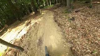
Je to široký a prehľadný, strojovo kopaný flowtrail (zatiaľ má v spodnej časti skôr prírodný charakter) so zhutneným hlineným povrchom, na ktorom sa nachádzajú klopené zákruty a malé vlny, ideálne pre začiatočníkov.
Trasa je vhodná pre všetky typy horských bicyklov, vrátane hardtailov a e-bikov.
Trať je iba zjazdová — ak chceš ísť hore, musíš použiť Prepojku a Výšľap Hore Hore alebo Výšľap pre labužníkov.

Local Trail Association

Recent Activity on Trail

Past Week
  • 0 rides
  •  
6 Months
  • 3 rides
  • 10 miles avg distance
All
  • 21 rides
  • Last: Jun 4, 2026
c1c2c3c4
January
February
March
April
May
June
July
August
September
October
November
December
update trails status or condition

Veget Trail Reports

statusdatedescription
Aug 9, 2025 @ 7:28am
Aug 9, 2025
Vyslap, Veget, and Prepojka were dry, clean and nice flowy today.
Nov 10, 2024 @ 7:02am
Nov 10, 2024
reporter Fajne vyfukane, suchucke, len jazdit
Jul 21, 2024 @ 7:17am
Jul 21, 2024
reporter
more »
Status:
on Aug 9, 2025
Dry
Avg: 4.13 (1 votes)
Your vote: 0

view (203)
close
3D
Trail Conditions
  • Unknown
  • Snow Groomed
  • Snow Packed
  • Snow Covered
  • Snow Cover Partial
  • Freeze/thaw Cycle
  • Icy
  • Prevalent Mud
  • Wet
  • Variable
  • Ideal
  • Dry
  • Very Dry
Trail Flow (Ridden Direction)
Trailforks scans users ridelogs to determine the most popular direction each trail is ridden. A good flowing trail network will have most trails flowing in a single direction according to their intension.
The colour categories are based on what percentage of riders are riding a trail in its intended direction.
  • > 96%
  • > 90%
  • > 80%
  • > 70%
  • > 50%
  • < 50%
  • bi-directional trail
  • no data
Trail Last Ridden
Trailforks scans ridelogs to determine the last time a trail was ridden.
  • < 2 days
  • < 1 week
  • < 2 weeks
  • < 1 month
  • < 6 months
  • > 6 months
Trail Ridden Direction
The intended direction a trail should be ridden.
  • Downhill Only
  • Downhill Primary
  • Both Directions
  • Uphill Primary
  • Uphill Only
  • One Direction
Contribute Details
Colors indicate trail is missing specified detail.
  • Description
  • Photos
  • Description & Photos
  • Videos
Trail Popularity ?
Trailforks scans ridelogs to determine which trails are ridden the most in the last 9 months. Trails are compared with nearby trails in the same city region with a possible 25 colour shades. Think of this as a heatmap, more rides = more kinetic energy = warmer colors.
  • most popular
  • popular
  • less popular
  • not popular
ATV/ORV/OHV Filter
Max Vehicle Width
inches
US Cell Coverage
Legend
cell carrier legend

Radar Time
Activity Recordings
Trailforks uses anonymized public activity data. ?
Activity Recordings
Trailforks uses anonymized public activity data. ?
Personal Heatmap
Activity Types
all / none
Options
2
Date range month
Winter Trails
Warning A routing network for winter maps does not exist. Selecting trails using the winter trails layer has been disabled.
Missing Trails
Most Popular
Least Popular
Trails are colored based on popularity. The more popular a trail is, the more red. Less popular trails trend towards green.
Jump Magnitude Heatmap
Heatmap of where riders jump on trails. Zoom in to see individual jumps, click circles to view jump details.
BC Backroad Status

Service Road Atlas is a free to use, community-driven service for viewing and creating reports on the numerous back-country service roads around B.C. and Alberta.

map legend
Slope Aspect
Direction the slope faces
Flat N NE E SE S SW W NW
Trails Deemphasized
Trails are shown in grey.
disable
Only show trails with no bike usage.
Enable
Suggested Layers
Based on selected activity type

    Save the current map location and zoom level as your default home location whenever this page is loaded.

    Save
        Directions to veget trailhead (49.310130, 21.326310)

        Photos

        9 more »
        51 |
        Jul 21, 2024 @ 6:00am
        Jul 21, 2024
        49 |
        Jul 21, 2024 @ 6:00am
        Jul 21, 2024
        49 |
        Jul 21, 2024 @ 6:00am
        Jul 21, 2024
        44 |
        Jul 21, 2024 @ 6:00am
        Jul 21, 2024

        Videos

        1 more »
        'Veget' Bardejovská Nová Ves, 12.7.2024
        3:43 | 266 | Jul 21, 2024 , Bardejov

        Reviews / Comments

        No reviews yet, be the first to write a review or ask a question.
        Use trail reports to comment on trail conditions.


        We hope you've been enjoying Trailforks!

        Create a FREE account to view trail comments and much more.

        • By popjak LSBK & contributors
        • #779294 - 296 views

        Frequently Asked Questions About Veget

        Where is Veget located?
        Veget is located in Bardejovská Nová Ves, Bardejov, Slovakia. It is part of the Bardejovská Nová Ves trail network. The trailhead is located at coordinates 49.31013, 21.32631.
        How hard is Veget?
        Veget is rated as Blue difficulty. The physical rating is Easy. The average grade is 11.3%.
        What is the elevation gain for Veget?
        The trail has 358 ft of elevation descent. The elevation ranges from 1,013 ft to 1,374 ft.
        How long is Veget?
        Veget is 3,196 ft long. The trail type is singletrack.

        Hit the Trail

        Open in App

        Get this trail on your phone instantly.
        open trail in app

        Download Trail

        Save to wishlist, Garmin & download.
        save the trail

        Find Related Routes

        Find routes and users activities that include this trail.
        find routes for this trail

        You must enter a description before submitting.