
more stats
1.5 miles
Distance
10 ft
Climb
-10 ft
Descent
00:14:27
Avg time
10 ft
Altitude min
16 ft
Altitude max
15 ft
Altitude start
16 ft
Altitude end
-1.9%
Grade max
1.4%
Grade min
561 ft
Distance climb
502 ft
Distance down
1 mile
Distance flat
00:14:27
Avg time

WKC Trail Details

  • Activities
    • Mountain Bike
    • Winter Fat Bike
    • Hike
    • Trail Running
  • Riding Area
    Tillie Fowler Regional Park
    Jacksonville, Florida
  • Difficulty Rating
  • Local Popularity
    70 in Mountain Biking heatmap [+]
    • 5 in Trail Running
    • 100 in Hiking
    • 5 in Winter Fat Biking
  • Global Ranking
    #89034 in Mountain Biking [+]
    • #297718 in Trail Running
    • #86696 in Hiking
    • #3323 in Winter Fat Biking
  • State Ranking
    #602 in Mountain Biking · Florida [+]
    • #1,468 in Trail Running
    • #392 in Hiking
    • #18 in Winter Fat Biking
  • Hiking SAC Scale
    T1 Hiking
  • Trail Type
    Singletrack
  • Bike Type
    AM, XC, Fat
  • Direction
    Both Directions
  • Climb Difficulty
    Green
  • Physical Rating
    Easy
  • Trail Visibility
    Sometimes hard to follow
  • Dogs Allowed
    Yes
  • TTFs on Trail
    Jump

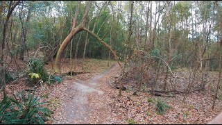
Great park to go ride with close access to town. This trail is the main loop that navigates the park and takes you to other little loops that increase in difficulty. This trail is mostly flat and pretty smooth and winds tightly through the trees in spots.

Access Info

Park is open during daylight hours.

Tags
Faint trailJumps

Local Trail Association

Traditionally Indigenous Territory

Recent Activity on Trail

Past Week
  • 6 rides
  • 6.6 km average
6 Months
  • 29 rides
  • 12.1 km avg distance
All
  • 549 rides
  • Last: Nov 16, 2026
c1c2c3c4
January
February
March
April
May
June
July
August
September
October
November
December
update trails status or condition

WKC Trail Trail Reports

statusdatedescription
Sep 5, 2026 @ 9:15am (America/Nassau)
Sep 5, 2026
Perfecto
Jun 10, 2026 @ 9:32am (America/New_York)
Jun 10, 2026
Getting overgrown
Jan 11, 2026 @ 1:21pm (America/New_York)
Jan 11, 2026
Nov 19, 2025 @ 12:11pm (America/Nassau)
Nov 19, 2025
Aug 9, 2024 @ 9:13pm
Aug 9, 2024
WKC Trail had 2 trees down. Wet in some spots but nothing terrible. Main jumpline had branches all over making it unrideable. However, the other...
more »
Status:
on Sep 5, 2026
Ideal
Avg: 3.72 (5 votes)
Your vote: 0

view (7,605)
close
      Directions to wkc-trail trailhead (30.232130, -81.701900)

      Photos

      7 more »
      mtb
      174 |
      Sep 18, 2022 @ 3:17pm
      Sep 18, 2022
      mtb
      162 |
      Sep 18, 2022 @ 3:17pm
      Sep 18, 2022
      mtb
      180 |
      Sep 18, 2022 @ 3:17pm
      Sep 18, 2022
      mtb
      237 |
      May 23, 2021 @ 10:52am
      May 23, 2021

      Videos

      2 more »
      Slow Roll through Tillie Fowler South
      mtb
      7:34 | 653 | Mar 7, 2020 , Jacksonville
      Mountain Biking at Tillie Fowler
      mtb
      8:27 | 1324 | Jan 10, 2018 , Jacksonville
      3.4 ★★★★★
      5 Ratings
      5 ★
      4 ★ 60%
      3 ★ 20%
      2 ★ 20%
      1 ★

      5 Reviews & Comments

      jdinflorida jdinflorida
      Rode the trails for the first time today. Fun for all levels. Nice pump track and jump line. I really enjoyed the big climbs/descents on the black trail.
      BenLow2019 BenLow2019
      Could use better signage and markings. With all the shortcuts, connectors, trails in progress and the jump line area with various return routes it’s easy to get doubled back on yourself. Fun riding though.
      Dangle9807
      The trail system was confusing at first but then a nice dude helped us not get lost

      We hope you've been enjoying Trailforks!

      Create a FREE account to view all trail reviews and much more.

      Frequently Asked Questions

      ▼ Where is WKC Trail located?
      WKC Trail is located in Tillie Fowler Regional Park, Jacksonville, Florida, United States. It is part of the Tillie Fowler Regional Park trail network. The trailhead is located at coordinates 30.23213, -81.7019.
      ▼ How hard is WKC Trail?
      WKC Trail is rated as Green difficulty. The physical rating is Easy. The climb difficulty is rated Green.
      ▼ What is the elevation gain for WKC Trail?
      WKC Trail has 10 ft of elevation gain. The trail has 10 ft of elevation descent. The elevation ranges from 10 ft to 16 ft.
      ▼ Is WKC Trail a point to point trail?
      WKC Trail is not a point to point trail. The direction is Both Directions. The trail type is singletrack.
      ▼ How long is WKC Trail?
      WKC Trail is 1.5 miles long. The trail type is singletrack.
      ▼ Are dogs allowed on WKC Trail?
      Yes, dogs are allowed on WKC Trail. Please keep dogs on a leash where required and clean up after them.
      ▼ How do I access WKC Trail? Where is the closest parking trailhead?
      The closest parking and trailhead locations to WKC Trail are: View all parking locations in the area.
      ▼ How long does it take to ride WKC Trail?
      Based on recorded activities, it takes an average of 14 minutes to ride WKC Trail. The trail is 1.5 miles long. Actual times will vary based on fitness level, conditions, and pace. View recent activity logs for more details.
      ▼ How busy is WKC Trail?
      WKC Trail is a very popular trail. There have been 2,906 recorded activities on this trail. The trail has received 7,605 check-ins. View recent activity on this trail.

      Hit the Trail

      Open in App

      Get this trail on your phone instantly.

      open trail in app

      Download Trail

      Save to wishlist, Garmin & download.
      save the trail

      Find Related Routes

      Find routes and users activities that include this trail.
      find routes for this trail

      You must enter a description before submitting.