
more stats
1.3 miles
Distance
17 ft
Climb
-377 ft
Descent
00:06:31
Avg time
-360 ft
Altitude change
1,198 ft
Altitude min
1,570 ft
Altitude max
1,558 ft
Altitude start
1,198 ft
Altitude end
-5.2%
Grade
-34.7%
Grade max
7.4%
Grade min
640 ft
Distance climb
1 mile
Distance down
627 ft
Distance flat
00:06:31
Avg time

Yegua Upper Details

  • Activities
    • Mountain Bike
    • E-Bike
    • Hike
    • Trail Running
  • Riding Area
    Gran Canaria
    Tejeda
  • Difficulty Rating
  • Local Popularity
    100 in Mountain Biking heatmap [+]
    • 100 in E-Biking
    • 5 in Trail Running
    • 5 in Hiking
  • Global Ranking
    #81035 in Mountain Biking [+]
    • #95268 in E-Biking
    • #354163 in Trail Running
    • #335558 in Hiking
  • National Ranking
    #5,608 in Mountain Biking · Spain [+]
    • #20,476 in E-Biking
    • #37,476 in Trail Running
    • #33,694 in Hiking
  • Hiking SAC Scale
    T1 Hiking
  • Trail Type
    Singletrack
  • Bike Type
    AM, XC
  • Direction
    Downhill Primary
  • Trail Visibility
    Always easy to follow
  • Dogs Allowed
    Yes
  • eBike Allowed
    Yes up to Class 1

Flowy trail along GC60 road

Tags
Flowy

Recent Activity on Trail

Past Week
  • 0 rides
  •  
6 Months
  • 7 rides
  • 13 miles avg distance
All
  • 128 rides
  • Last: Nov 18, 2026
c1c2c3c4
January
February
March
April
May
June
July
August
September
October
November
December
Status:
on Jan 29, 2026
Dry
Avg: 4.21 (3 votes)
Your vote: 0

view (2,185)
close
      Directions to yegua-upper trailhead (27.818930, -15.577980)

      Photos

      4 more »
      mtb
      129 |
      Mar 21, 2022 @ 7:19am
      Mar 21, 2022
      mtb
      107 |
      Mar 21, 2022 @ 7:19am
      Mar 21, 2022
      mtb
      105 |
      Mar 21, 2022 @ 7:19am
      Mar 21, 2022
      mtb
      191 |
      Mar 21, 2022 @ 7:19am
      Mar 21, 2022

      Videos

      1 more »
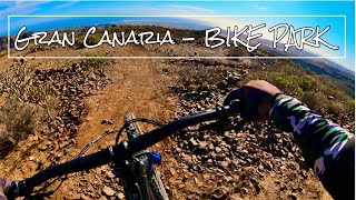
      Gran Canaria's Bike Park!
      mtb
      3:34 | 274 | Dec 27, 2024 , Tejeda

      Routes with this trail

      more »
      26 miles • 4,568 ft • 11 • Loop •
      Route in Maspalomas from "Life on 2 wheels" following road up and descening down handbuilt mtb track. Go...
      24 miles • 3,809 ft • 6 •
      Ruta para hacer con E-bike, con los descensos de el mirador de la degollada, repitiendo el primer sector y...
      4.7 ★★★★★
      3 Ratings
      5 ★ 67%
      4 ★ 33%
      3 ★
      2 ★
      1 ★

      3 Reviews & Comments

      Animalcontrol Animalcontrol
      It’s a blue flow trail. Nothing to special about the trail it self but the location is cool. The trail get better as you go.
      juliegranger
      Fun trail! Dirt in the walls of some of the berms near the tops was a little loosely packed so it didn’t make for great berm riding, but that’s my only feedback, and that’s minor at best. The rest was super fun. Options for ridearounds on some of the features if you’re more of an intermediate rider like me. Also — Pony (near top) is VERY steep! We took the other option on the main trail.
      ftigu30 ftigu30
      Brilliant trail good flo with options of steep if u want. Nice jumps n rock gardens

      We hope you've been enjoying Trailforks!

      Create a FREE account to view all trail reviews and much more.

      • By blaze-jTF Pro & contributors
      • #513190 - 1,142 views

      Frequently Asked Questions

      ▼ Where is Yegua Upper located?
      Yegua Upper is located in Gran Canaria, Tejeda, Spain. It is part of the Gran Canaria trail network. The trailhead is located at coordinates 27.81893, -15.57798.
      ▼ How hard is Yegua Upper?
      Yegua Upper is rated as Blue difficulty. The average grade is 5.2%.
      ▼ What is the elevation gain for Yegua Upper?
      Yegua Upper has 17 ft of elevation gain. The trail has 377 ft of elevation descent. The elevation ranges from 1,198 ft to 1,570 ft.
      ▼ Is Yegua Upper a point to point trail?
      Yegua Upper is not a point to point trail. The direction is Downhill Primary. The trail type is singletrack.
      ▼ How long is Yegua Upper?
      Yegua Upper is 1.3 miles long. The trail type is singletrack.
      ▼ Are dogs allowed on Yegua Upper?
      Yes, dogs are allowed on Yegua Upper. Please keep dogs on a leash where required and clean up after them.
      ▼ How long does it take to ride Yegua Upper?
      Based on recorded activities, it takes an average of 7 minutes to ride Yegua Upper. The trail is 1.3 miles long. Actual times will vary based on fitness level, conditions, and pace. View recent activity logs for more details.
      ▼ How busy is Yegua Upper?
      Yegua Upper is a very popular trail. There have been 2,049 recorded activities on this trail. The trail has received 2,185 check-ins. View recent activity on this trail.

      Hit the Trail

      Open in App

      Get this trail on your phone instantly.

      open trail in app

      Download Trail

      Save to wishlist, Garmin & download.
      save the trail

      Find Related Routes

      Find routes and users activities that include this trail.
      find routes for this trail

      You must enter a description before submitting.

