Covering around 120 kilometres, this tour connects the four cantons of Valais, Uri, Grisons and Ticino in five stages. You cross four passes: you start on the Nufenen Pass, followed by Furka, Oberalp and Lukmanier. There is also plenty of trail fun to be had on the tour around the Gotthard. You can miss out some of the climb by taking postbuses, trains and cable cars.
From Upper Valais to Ticino in five stages. This challenging mountain bike tour explores the Gotthard area, and it starts off spectacularly: at the second highest pass in Switzerland, the Nufenen. The first descent is technical, fast and has some excellent views. It then starts to flow, and the stage ends comfortably along the Rhone Route in Oberwald.
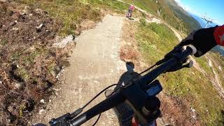
Next stage and next Alpine pass: the post bus takes you from Oberwald to the Furka Pass, where you tackle the so-called “Urschner Höhenweg” trail. On a panoramic path with a superb view across the valley, you pass several small lakes before a winding single trail snakes down to the Hospental valley.
All good things come in threes: next on the biking itinerary is the Oberalp Pass. Or are we by the sea? The lighthouse seems a little out of place up here: it symbolises the source of the Rhine, and it presents a popular photo opportunity. But we are here for mountain biking: the journey continues across the Tiarms Pass, then up and down through three valleys to the destination of Sedrun.
The fourth stage is set to be very flowing: after a cable car ride, the Catrina Flow Trail winds its way down the mountain in waves and curves. It is followed by the crossing to the Bostg with its proliferation of flowers. This is an incredible panoramic mountain near Disentis. The destination is impressive with its Benedictine monastery.
Fourth stage, fourth pass: the postbus takes you conveniently up to the Lukmanier. Passing the Centro Pro Natura Lucomagno, the tour ends in Campra, where the last stage begins. It runs through the sunny valley, the Valle di Blenio. Mule trails, thermal baths, grottos, a castle, museums and vineyards – the final stage once again shows what Ticino has to offer.
From Upper Valais to Ticino in five stages. This challenging mountain bike tour explores the Gotthard area, and it starts off spectacularly: at the second highest pass in Switzerland, the Nufenen. The first descent is technical, fast and has some excellent views. It then starts to flow, and the stage ends comfortably along the Rhone Route in Oberwald.
Next stage and next Alpine pass: the post bus takes you from Oberwald to the Furka Pass, where you tackle the so-called “Urschner Höhenweg” trail. On a panoramic path with a superb view across the valley, you pass several small lakes before a winding single trail snakes down to the Hospental valley.
All good things come in threes: next on the biking itinerary is the Oberalp Pass. Or are we by the sea? The lighthouse seems a little out of place up here: it symbolises the source of the Rhine, and it presents a popular photo opportunity. But we are here for mountain biking: the journey continues across the Tiarms Pass, then up and down through three valleys to the destination of Sedrun.
The fourth stage is set to be very flowing: after a cable car ride, the Catrina Flow Trail winds its way down the mountain in waves and curves. It is followed by the crossing to the Bostg with its proliferation of flowers. This is an incredible panoramic mountain near Disentis. The destination is impressive with its Benedictine monastery.
Fourth stage, fourth pass: the postbus takes you conveniently up to the Lukmanier. Passing the Centro Pro Natura Lucomagno, the tour ends in Campra, where the last stage begins. It runs through the sunny valley, the Valle di Blenio. Mule trails, thermal baths, grottos, a castle, museums and vineyards – the final stage once again shows what Ticino has to offer.
- Mountain Bike
- E-Bike
Login to see your progress towards riding all the trails and routes in this list.
Trails
| title | riding area | rating | distance | completed | |||
|---|---|---|---|---|---|---|---|
| 1 | Bostg - Mises dil Bostg | 2,385 ft | |||||
| 2 | Caischavedra Connectur | 1,115 ft | |||||
| 3 | Campra Connector #84 Stage 5 | 2 miles | |||||
| 4 | CATRINA Flow Trail | 2 miles | |||||
| 5 | Crunas | 4,488 ft | |||||
| 6 | Fontanelle #84 Stage 5 | 3,386 ft | |||||
| 7 | Fontauna ll | 1,204 ft | |||||
| 8 | Gassa da Cuoz | 4,669 ft | |||||
| 9 | Hundschepfene | 1 mile | |||||
| 10 | Kitt Gravel | 3,717 ft | |||||
| 11 | L'Ondadusa Fontauna Sogn Gion | 1 mile | |||||
| 12 | Lakeside | 2 miles | |||||
| 13 | Liez | 2 miles | |||||
| 14 | Malamusa | 3,957 ft | |||||
| 15 | Mila Rodunda | 4,626 ft | |||||
| 16 | Nufenenpass | 1,978 ft | |||||
| 17 | Nufenenpass Wallis | 3,294 ft | |||||
| 18 | Oberalpsee | 5,062 ft | |||||
| 19 | Pass Tiarms | 4,426 ft | |||||
| 20 | Prau Strems | 1,690 ft | |||||
| 21 | Rossmettlen | 2 miles | |||||
| 22 | Sacch - Camperio #84 Stage 5 | 1 mile | |||||
| 23 | Segno to Campra | 3,356 ft | |||||
| 24 | Senda Cuolm Da Vi | 1 mile | |||||
| 25 | Senda di Bostg | 3,724 ft | |||||
| 26 | Senda Pauli | 2 miles | |||||
| 27 | Sommascona Connector #84 Stage 5 | 1,493 ft | |||||
| 28 | Stocklamme | 1 mile | |||||
| 29 | Tiarms/Cuelm Val | 2 miles | |||||
| 30 | Urseren Höhenweg | 4 miles | |||||
| 31 | Urseren Höhenweg Access | 3 miles | |||||
| 32 | Val d Aegina | 2 miles | |||||
| 33 | Via Cuolm Val | 1 mile | |||||
| 34 | Via Lucomagno Olivone #84 Stage 5 | 3,698 ft | |||||
| 35 | Via Prau Sura | 1 mile | |||||
| 36 | Via Tguinter | 4,265 ft | |||||
| 37 | Via Valtgeva | 1,473 ft |
Displaying 37
Videos
0:00 |
496 |
Apr 4, 2022 , Disentis Sedrun
Recent Trail Reports
| status | trail | date | condition | |
|---|---|---|---|---|
| Urseren Höhenweg | Jun 20, 2026 @ 10:36am (Europe/Zurich) 1 day | view | ||
| Via Tguinter | Jun 14, 2026 @ 10:54am (Europe/Zurich) Jun 14, 2026 | view | ||
| Crunas | Jun 14, 2026 @ 10:54am (Europe/Zurich) Jun 14, 2026 | view | ||
| Malamusa | Jun 14, 2026 @ 10:54am (Europe/Zurich) Jun 14, 2026 | view | ||
| Mila Rodunda | Jun 14, 2026 @ 10:54am (Europe/Zurich) Jun 14, 2026 | view |
Total Trails
37
Total Distance
42 miles
Total Descent
-17,096 ft
Total Climb
4,524 ft
close
-
Layers w
- Weather Layers
- Pro
- Pro
- Pro
- Pro
- Pro
- Pro
- More Layers
- Pro
- Pro
- Pro
- Pro
-
Upgrade to

3D
Trail Conditions
- Unknown
- Snow Groomed
- Snow Packed
- Snow Covered
- Snow Cover Partial
- Freeze/thaw Cycle
- Icy
- Prevalent Mud
- Wet
- Variable
- Ideal
- Dry
- Very Dry
Trail Flow (Ridden Direction)
Trailforks scans users ridelogs to determine the most popular direction each trail is ridden. A good flowing trail network will have most trails flowing in a single direction according to their intension.
The colour categories are based on what percentage of riders are riding a trail in its intended direction.
The colour categories are based on what percentage of riders are riding a trail in its intended direction.
- > 96%
- > 90%
- > 80%
- > 70%
- > 50%
- < 50%
- bi-directional trail
- no data
Trail Last Ridden
Trailforks scans ridelogs to determine the last time a trail was ridden.
- < 2 days
- < 1 week
- < 2 weeks
- < 1 month
- < 6 months
- > 6 months
Trail Ridden Direction
The intended direction a trail should be ridden.
- Downhill Only
- Downhill Primary
- Both Directions
- Uphill Primary
- Uphill Only
- One Direction
Contribute Details
Colors indicate trail is missing specified detail.
- Description
- Photos
- Description & Photos
- Videos
Trail Popularity ?
Trailforks scans ridelogs to determine which trails are ridden the most in the last 9 months.
Trails are compared with nearby trails in the same city region with a possible 25 colour shades.
Think of this as a heatmap, more rides = more kinetic energy = warmer colors.
- most popular
- popular
- less popular
- not popular
ATV/ORV/OHV Filter
Max Vehicle Width
inches
US Cell Coverage
Legend

Radar Time
Activity Recordings
Trailforks uses anonymized public activity data.
?
Activity Recordings
Trailforks uses anonymized public activity data.
?
Personal Heatmap
▶
Activity Types
all
/
none
▶
Options
2
Date range
month
–
Winter Trails
Warning
A routing network for winter maps does not exist. Selecting trails using the winter trails layer has been disabled.
Missing Trails
Most Popular
Least Popular
Trails are colored based on popularity. The more popular a trail is, the more red. Less popular trails trend towards green.
Jump Magnitude Heatmap
Heatmap of where riders jump on trails. Zoom in to see individual jumps, click circles to view jump details.
BC Backroad Status
![map legend]()
Service Road Atlas is a free to use, community-driven service for viewing and creating reports on the numerous back-country service roads around B.C. and Alberta.

Slope Aspect
Direction the slope faces
Trails Deemphasized
Trails are shown in grey.
Only show trails with no bike usage.
Suggested Layers
Based on selected activity type
Save the current map location and zoom level as your default home location whenever this page is loaded.
Save
Trail transparency
This official route list of trails is not complete
Average difficulty
Trails and Routes in List - Distance by Difficulty
Trails and Routes in List - Difficulty Totals
- By trailpapst
 TRAILFORKS swiss IMBA SCHWEIZ
 - #2114 - 734 views