The Israel Bike Trail is a national project whose purpose is to create a continuous mountain biking trail that crosses the country from north to south, connecting Mt. Hermon at one end with Eilat at the other.
The Israel Nature and Parks Authority is leading the establishment of this trail, in partnership with the Ministry of Tourism and The Israel Government Tourism Corporation and with assistance from additional bodies such as the Ministry of Agriculture, the Ministry of Environmental Protection and the Jewish National Fund.
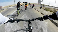
One of the important goals behind the decision to found the trail is to encourage bicycle tourism, both foreign and from within Israel. Therefore, the planning process was carried out with a focus on showcasing the best that Israel has to offer. Whoever rides the entire length of the trail will pass through the most important national sites and cross the country's most magnificent landscapes, while experiencing Israel's diversity of culture and types of communities along the way.
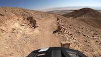
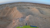
The trail one of the longest demarcated trails in the world suited to, and with appropriate signage for, mountain biking. It overlaps early caravan routes to link some of the most ancient and sacred heritage sites of the three monotheistic religions. It will enable riders to travel from the snow on Mt. Hermon to the southern desert, from the stone ruins where our ancestors lived to the concrete towers of a bustling metropolis, encompassing thousands of years of history and hundreds of million years of geology.
The sections of the trail were planned so that each one should take up to a day (6–8 hours) to complete, ending in a location with sleeping accommodations and water. So far, 300 kilometers of the planned route have been prepared for use, connecting Makhtesh Ramon and Eilat. This section can be completed in eight days of exhilarating riding through spectacular desert landscape.
A community of volunteers has grown who donate their time and energy to clearing and leveling sections of the Israel Bike Trail. We take this opportunity to thank those who have participated for their impressive and heartwarming devotion, and to appeal to new volunteers – come join us!
The Israel Nature and Parks Authority is leading the establishment of this trail, in partnership with the Ministry of Tourism and The Israel Government Tourism Corporation and with assistance from additional bodies such as the Ministry of Agriculture, the Ministry of Environmental Protection and the Jewish National Fund.
One of the important goals behind the decision to found the trail is to encourage bicycle tourism, both foreign and from within Israel. Therefore, the planning process was carried out with a focus on showcasing the best that Israel has to offer. Whoever rides the entire length of the trail will pass through the most important national sites and cross the country's most magnificent landscapes, while experiencing Israel's diversity of culture and types of communities along the way.
The trail one of the longest demarcated trails in the world suited to, and with appropriate signage for, mountain biking. It overlaps early caravan routes to link some of the most ancient and sacred heritage sites of the three monotheistic religions. It will enable riders to travel from the snow on Mt. Hermon to the southern desert, from the stone ruins where our ancestors lived to the concrete towers of a bustling metropolis, encompassing thousands of years of history and hundreds of million years of geology.
The sections of the trail were planned so that each one should take up to a day (6–8 hours) to complete, ending in a location with sleeping accommodations and water. So far, 300 kilometers of the planned route have been prepared for use, connecting Makhtesh Ramon and Eilat. This section can be completed in eight days of exhilarating riding through spectacular desert landscape.
A community of volunteers has grown who donate their time and energy to clearing and leveling sections of the Israel Bike Trail. We take this opportunity to thank those who have participated for their impressive and heartwarming devotion, and to appeal to new volunteers – come join us!
- Mountain Bike
- E-Bike
Login to see your progress towards riding all the trails and routes in this list.
Trails
| title | riding area | rating | distance | completed | |||
|---|---|---|---|---|---|---|---|
| 1 | Arad to Kannaim | 14 miles | |||||
| 2 | Avdat - HaRuhot Jct. | 15 miles | |||||
| 3 | Be'erot - Moa | 20 miles | |||||
| 4 | Beerot Khan - Mahmal | 4 miles | |||||
| 5 | Hava - section 1 | 9 miles | |||||
| 6 | Hava - section 2 | 8 miles | |||||
| 7 | Hava - section 3 | 3 miles | |||||
| 8 | Havarim - Avdat | 8 miles | |||||
| 9 | Kannaim | 6 miles | |||||
| 10 | Ketura Ascend | 5 miles | |||||
| 11 | Masada to Nave Zohar | 21 miles | |||||
| 12 | Moa to Paran | 20 miles | |||||
| 13 | Neot Smadar - Shaharut | 16 miles | |||||
| 14 | Paran - Yahel | 27 miles |
Displaying 14
Videos
3:54 |
122 |
Dec 3, 2023
4:38 |
142 |
Sep 16, 2022
8:26 |
207 |
Apr 3, 2016
Recent Trail Reports
| status | trail | date | condition | |
|---|---|---|---|---|
| Neot Smadar - Shaharut | Dec 10, 2025 @ 8:40am (Asia/Jerusalem) Dec 9, 2025 | view | ||
| Be'erot - Moa | Aug 24, 2025 @ 2:20am Aug 24, 2025 | view | ||
| Hava - section 2 | Mar 20, 2024 @ 2:25am Mar 20, 2024 | view | ||
| Hava - section 3 | Mar 20, 2024 @ 2:25am Mar 20, 2024 | view | ||
| Hava - section 1 | Mar 20, 2024 @ 2:25am Mar 20, 2024 | view |
Total Trails
14
Total Distance
178 miles
Total Descent
-15,090 ft
Total Climb
10,059 ft
close
-
Layers w
- Weather Layers
- Pro
- Pro
- Pro
- Pro
- Pro
- Pro
- More Layers
- Pro
- Pro
- Pro
- Pro
-
Upgrade to

3D
Trail Conditions
- Unknown
- Snow Groomed
- Snow Packed
- Snow Covered
- Snow Cover Partial
- Freeze/thaw Cycle
- Icy
- Prevalent Mud
- Wet
- Variable
- Ideal
- Dry
- Very Dry
Trail Flow (Ridden Direction)
Trailforks scans users ridelogs to determine the most popular direction each trail is ridden. A good flowing trail network will have most trails flowing in a single direction according to their intension.
The colour categories are based on what percentage of riders are riding a trail in its intended direction.
The colour categories are based on what percentage of riders are riding a trail in its intended direction.
- > 96%
- > 90%
- > 80%
- > 70%
- > 50%
- < 50%
- bi-directional trail
- no data
Trail Last Ridden
Trailforks scans ridelogs to determine the last time a trail was ridden.
- < 2 days
- < 1 week
- < 2 weeks
- < 1 month
- < 6 months
- > 6 months
Trail Ridden Direction
The intended direction a trail should be ridden.
- Downhill Only
- Downhill Primary
- Both Directions
- Uphill Primary
- Uphill Only
- One Direction
Contribute Details
Colors indicate trail is missing specified detail.
- Description
- Photos
- Description & Photos
- Videos
Trail Popularity ?
Trailforks scans ridelogs to determine which trails are ridden the most in the last 9 months.
Trails are compared with nearby trails in the same city region with a possible 25 colour shades.
Think of this as a heatmap, more rides = more kinetic energy = warmer colors.
- most popular
- popular
- less popular
- not popular
ATV/ORV/OHV Filter
Max Vehicle Width
inches
US Cell Coverage
Legend

Radar Time
Activity Recordings
Trailforks uses anonymized public activity data.
?
Activity Recordings
Trailforks uses anonymized public activity data.
?
Personal Heatmap
▶
Activity Types
all
/
none
▶
Options
2
Date range
month
–
Winter Trails
Warning
A routing network for winter maps does not exist. Selecting trails using the winter trails layer has been disabled.
Missing Trails
Most Popular
Least Popular
Trails are colored based on popularity. The more popular a trail is, the more red. Less popular trails trend towards green.
Jump Magnitude Heatmap
Heatmap of where riders jump on trails. Zoom in to see individual jumps, click circles to view jump details.
BC Backroad Status
![map legend]()
Service Road Atlas is a free to use, community-driven service for viewing and creating reports on the numerous back-country service roads around B.C. and Alberta.

Slope Aspect
Direction the slope faces
Trails Deemphasized
Trails are shown in grey.
Only show trails with no bike usage.
Suggested Layers
Based on selected activity type
Save the current map location and zoom level as your default home location whenever this page is loaded.
Save
Trail transparency
This official route list of trails is not complete
Average difficulty
Associated Route
Trails and Routes in List - Distance by Difficulty
Trails and Routes in List - Difficulty Totals
- By ziv2102
 TRAILFORKS
 - #793 - 2,617 views