close
-
Layers w
- Weather Layers
- Pro
- Pro
- Pro
- Pro
- Pro
- Pro
- More Layers
- Pro
- Pro
- Pro
- Pro
-
Upgrade to

3D
Trail Conditions
- Unknown
- Snow Groomed
- Snow Packed
- Snow Covered
- Snow Cover Partial
- Freeze/thaw Cycle
- Icy
- Prevalent Mud
- Wet
- Variable
- Ideal
- Dry
- Very Dry
Trail Flow (Ridden Direction)
Trailforks scans users activity logs to determine the most popular direction each trail is ridden. A good flowing trail network will have most trails flowing in a single direction according to their intension.
The colour categories are based on what percentage of users are riding a trail in its intended direction.
The colour categories are based on what percentage of users are riding a trail in its intended direction.
- > 96%
- > 90%
- > 80%
- > 70%
- > 50%
- < 50%
- bi-directional trail
- no data
Trail Last Ridden
Trailforks scans activity logs to determine the last time a trail was ridden.
- < 2 days
- < 1 week
- < 2 weeks
- < 1 month
- < 6 months
- > 6 months
Trail Ridden Direction
The intended direction a trail should be ridden.
- Downhill Only
- Downhill Primary
- Both Directions
- Uphill Primary
- Uphill Only
- One Direction
Contribute Details
Colors indicate trail is missing specified detail.
- Description
- Photos
- Description & Photos
- Videos
Trail Popularity ?
Trailforks scans activity logs to determine which trails are ridden the most in the last 9 months.
Trails are compared with nearby trails in the same city region with a possible 25 colour shades.
Think of this as a heatmap, more activities = more kinetic energy = warmer colors.
- most popular
- popular
- less popular
- not popular
ATV/ORV/OHV Filter
Max Vehicle Width
inches
US Cell Coverage
Legend

Radar Time
Activity Recordings
Trailforks uses anonymized public activity data.
?
Activity Recordings
Trailforks uses anonymized public activity data.
?
Personal Heatmap
▶
Activity Types
all
/
none
▶
Options
2
Date range
month
–
Winter Trails
Warning
A routing network for winter maps does not exist. Selecting trails using the winter trails layer has been disabled.
Missing Trails
Most Popular
Least Popular
Trails are colored based on popularity. The more popular a trail is, the more red. Less popular trails trend towards green.
Jump Magnitude Heatmap
Heatmap of where users jump on trails. Zoom in to see individual jumps, click circles to view jump details.
BC Backroad Status
![map legend]()
Service Road Atlas is a free to use, community-driven service for viewing and creating reports on the numerous back-country service roads around B.C. and Alberta.

Slope Aspect
Direction the slope faces
Trails Deemphasized
Trails are shown in grey.
Only show trails with no bike usage.
Suggested Layers
Based on selected activity type
Save the current map location and zoom level as your default home location whenever this page is loaded.
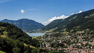
SaveAllevard est une commune française située dans le département de l'Isère en région Auvergne-Rhône-Alpes, autrefois rattachée à l'ancienne province du Dauphiné. La commune est également connue sous le nom d'Allevard-les-Bains, en raison de la présence d'un service de cure thermal
This region uses the Uk/Euro style trail grading system.
Activities Click to view
- Mountain Bike
9 trails
- E-Bike
9 trails
- Horse
0 trails
- Hike
7 trails
- Trail Running
7 trails
Region Details
- 2
- 5
- 1
Region Status
Open as of May 21, 2026Stats
- Avg Trail Rating
- Trails (view details)
- 8
- Trails Mountain Bike
- 9
- Trails E-Bike
- 9
- Trails Hike
- 7
- Trails Trail Running
- 7
- Trails Dirtbike/Moto
- 1
- Total Distance
- 8 miles
- Total Descent Distance
- 8 miles
- Total Descent
- 8,460 ft
- Total Vertical
- 3,828 ft
- Highest Trailhead
- 5,491 ft
- Photos
- 19
- Completed Counter
- 8
Popular Allevard Mountain Biking Trails
• 5 ★ 0.0 • 1 mile • 20 ft • 1 •
Single assez joueur sur la fin ,quelque sauts
• 5 ★ 5.0 • 2 miles • 2 ft • 1 • • hike
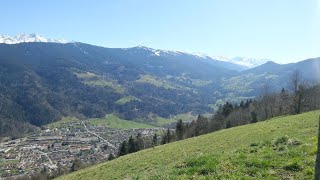
Depart sur la piste des cretes pres de l antenne de brame farine ..le debut n est pas tres bien visible et ca ressemble plus a une piste ,puis vers le chaney ca devient un single pentu par moment ..la fin arrive au cimetiere de allevard...
• ★ 5.0 • 3,074 ft • 0 ft • 1 • • hike
La suite de la descente de brame farine ,dh st pierre d allevard ..qui descend vers ,on peut enchainer avec le single qui descend vers le cheylas ..michmich
• 5 ★ 0.0 • 538 ft • 0 ft •
Less popular red difficulty singletrack. This multi-use trail can be used downhill primary.
• 5 ★ 0.0 • 4,006 ft • 0 ft •
Less popular red difficulty singletrack. This mountain bike primary trail can be used both directions.
• 5 ★ 0.0 • 1,877 ft • 0 ft •
Less popular red difficulty singletrack. This mountain bike primary trail can be used downhill only. Trail visibility is always easy to follow.
Photos of Allevard Mountain Bike
Videos of Allevard Mountain Bike
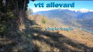
trail: Les Mollies
8:35 |
66 |
Mar 12, 2023 , Allevard
trail: Les Haguards
7:55 |
44 |
Feb 3, 2023 , Allevard
8:03 |
111 |
Jan 31, 2023 , Allevard
Activity Feed
| username | action | type | title | date |
|---|---|---|---|---|
| provencemb | update | region | activity #96658861 | Jun 10, 2026 @ 1:25am Jun 10, 2026 |
| uqU83T | add | trail | activity #96654090 and 2 more | Jun 9, 2026 @ 10:27pm Jun 9, 2026 |
| auriandig | wishlist | trail | activity #69350743 | Apr 10, 2025 @ 7:35am Apr 10, 2025 |
| provencemb | add | trail | activity #55333866 | Jul 8, 2024 @ 7:20am Jul 8, 2024 |
| Anthonov420 | wishlist | trail | activity #44388366 and 1 more | Sep 22, 2023 @ 1:02am Sep 22, 2023 |
Recent Comments
| username | type | title | comment | date |
|---|---|---|---|---|
| trail | Sentier qui va droit dedans globalement... | Mar 6, 2023 @ 11:44pm Mar 6, 2023 | ||
| trail | Tres joli single finale ..sur la video joint... | Jan 31, 2023 @ 1:08am Jan 31, 2023 |
Activity Type Stats
| activitytype | trails | distance | descent | descent distance | total vertical | rating | global rank | state rank | photos | reports | routes | activity logs |
|---|---|---|---|---|---|---|---|---|---|---|---|---|
| Mountain Bike | 9 | 8 miles | 8,461 ft | 8 miles | 3,829 ft | #4,643 | #168 | 19 | 89 | |||
| E-Bike | 9 | 8 miles | 8,461 ft | 8 miles | 3,829 ft | #5,613 | #400 | 6 | ||||
| Hike | 7 | 6 miles | 6,936 ft | 6 miles | 2,930 ft | #9,226 | #435 | 17 | ||||
| Trail Running | 7 | 6 miles | 6,936 ft | 6 miles | 2,930 ft | #8,942 | #429 | 4 | ||||
| Dirtbike/Moto | 1 | 4,006 ft | 479 ft | 3,839 ft | 479 ft |
Frequently Asked Questions About Allevard
▼
What are the highest rated mountain biking trails in Allevard?
The highest rated mountain biking trails in Allevard are:
- Chapit (4.1/5)
- Les Haguards (4.1/5)
- Vtt Dh chapelle du bard partie 1 (0/5)
- Vtt Dh chapelle du bard partie 3 (0/5)
- Vtt Dh chapelle du bard partie 2 (0/5)
▼
Where can I park to ride in Allevard?
Check the Allevard trail map for trailhead and parking information. Community members regularly update access and parking details for trails in the area.
▼
What is the longest trail in Allevard?
The longest trail in Allevard is Chapit at 1.7 miles. View all trails sorted by distance.
▼
What are the best & highest rated hiking trails in Allevard?
The best hiking trails in Allevard are: View all hiking trails sorted by popularity score.
- By freerider48
 TRAILFORKS TFFRANCE & contributors
 - Admins: B MTB Co, JordiBN, Whipperman
- #55421 - 727 views
- allevard activity log | embed map of Allevard mountain bike trails |
Downloading of trail gps tracks in kml & gpx formats is enabled for Allevard.
You must login to download files.