close
-
Layers w
- Weather Layers
- Pro
- Pro
- Pro
- Pro
- Pro
- Pro
- More Layers
- Pro
- Pro
- Pro
- Pro
-
Upgrade to

3D
Trail Conditions
- Unknown
- Snow Groomed
- Snow Packed
- Snow Covered
- Snow Cover Partial
- Freeze/thaw Cycle
- Icy
- Prevalent Mud
- Wet
- Variable
- Ideal
- Dry
- Very Dry
Trail Flow (Ridden Direction)
Trailforks scans users activity logs to determine the most popular direction each trail is ridden. A good flowing trail network will have most trails flowing in a single direction according to their intension.
The colour categories are based on what percentage of users are riding a trail in its intended direction.
The colour categories are based on what percentage of users are riding a trail in its intended direction.
- > 96%
- > 90%
- > 80%
- > 70%
- > 50%
- < 50%
- bi-directional trail
- no data
Trail Last Ridden
Trailforks scans activity logs to determine the last time a trail was ridden.
- < 2 days
- < 1 week
- < 2 weeks
- < 1 month
- < 6 months
- > 6 months
Trail Ridden Direction
The intended direction a trail should be ridden.
- Downhill Only
- Downhill Primary
- Both Directions
- Uphill Primary
- Uphill Only
- One Direction
Contribute Details
Colors indicate trail is missing specified detail.
- Description
- Photos
- Description & Photos
- Videos
Trail Popularity ?
Trailforks scans activity logs to determine which trails are ridden the most in the last 9 months.
Trails are compared with nearby trails in the same city region with a possible 25 colour shades.
Think of this as a heatmap, more activities = more kinetic energy = warmer colors.
- most popular
- popular
- less popular
- not popular
ATV/ORV/OHV Filter
Max Vehicle Width
inches
US Cell Coverage
Legend

Radar Time
Activity Recordings
Trailforks uses anonymized public activity data.
?
Activity Recordings
Trailforks uses anonymized public activity data.
?
Personal Heatmap
▶
Activity Types
all
/
none
▶
Options
2
Date range
month
–
Winter Trails
Warning
A routing network for winter maps does not exist. Selecting trails using the winter trails layer has been disabled.
Missing Trails
Most Popular
Least Popular
Trails are colored based on popularity. The more popular a trail is, the more red. Less popular trails trend towards green.
Jump Magnitude Heatmap
Heatmap of where users jump on trails. Zoom in to see individual jumps, click circles to view jump details.
BC Backroad Status
![map legend]()
Service Road Atlas is a free to use, community-driven service for viewing and creating reports on the numerous back-country service roads around B.C. and Alberta.

Slope Aspect
Direction the slope faces
Trails Deemphasized
Trails are shown in grey.
Only show trails with no bike usage.
Suggested Layers
Based on selected activity type
Save the current map location and zoom level as your default home location whenever this page is loaded.
Save
No description for Arles-sur-Tech has been added yet!
Login or register to submit one.
This region uses the Uk/Euro style trail grading system.
Activities Click to view
- Mountain Bike
26 trails
- E-Bike
22 trails
- Adaptive Bike
0 trails
- Winter Fat Bike
0 trails
- Hike
23 trails
- Trail Running
23 trails
Region Details
- 7
- 1
- 6
- 8
- 2
Region Status
Caution as of May 31, 2026Stats
- Avg Trail Rating
- Trails (view details)
- 24
- Trails Mountain Bike
- 26
- Trails E-Bike
- 22
- Trails Hike
- 23
- Trails Trail Running
- 23
- Total Distance
- 49 miles
- Total Descent Distance
- 21 miles
- Total Descent
- 16,355 ft
- Total Vertical
- 4,778 ft
- Highest Trailhead
- 5,640 ft
- Reports
- 25
- Photos
- 8
- Completed Counter
- 188
Popular Arles-sur-Tech Mountain Biking Trails
• 90 ★ 4.4 • 3 miles • 34 ft • 19 • • hike
Popular black difficulty singletrack. This hike primary trail can be used downhill primary and has a moderate overall physical rating. Trail visibility is sometimes hard to follow. On average it takes 32 minutes to complete this trail.
• 80 ★ 4.4 • 2 miles • 282 ft • 11 • • hike
Popular red difficulty singletrack. This hike primary trail can be used downhill primary. It features a-frame. On average it takes 1 hour1 minutes to complete this trail.
• 5 ★ 4.0 • 3 miles • 8 ft • 6 • • hike
Less popular black difficulty singletrack. This hike primary trail can be used downhill primary and has a hard overall physical rating with a 8 ft green climb. Trail visibility is always easy to follow. On average it takes 4 minutes to complete this trail.
• 85 ★ 5.0 • 3,261 ft • 31 ft • 4 • • hike
Popular blue difficulty family friendly singletrack. This hike primary trail can be used both directions and has a moderate overall physical rating with a 31 ft blue climb. Trail visibility is always easy to follow.
• 45 ★ 5.0 • 1,247 ft • 0 ft • 4 • • hike
Moderately popular red difficulty singletrack. This hike primary trail can be used downhill only and has a moderate overall physical rating with a 0 ft blue climb. Trail visibility is always easy to follow. On average it takes 5 minutes to complete this trail.
• 70 ★ 5.0 • 4,281 ft • 37 ft • 3 • • hike
Popular red difficulty singletrack. This hike primary trail can be used downhill only and has a moderate overall physical rating with a 37 ft blue climb. Trail visibility is always easy to follow. On average it takes 9 minutes to complete this trail.
• 40 ★ 0.0 • 3,993 ft • 156 ft • 3 • • hike
Moderately popular red difficulty family friendly singletrack. This hike primary trail can be used downhill only and has a moderate overall physical rating with a 156 ft blue climb. Trail visibility is always easy to follow.
• 5 ★ 4.7 • 3 miles • 0 ft • 3 • • hike
Le haut est un mélange de terre + grosses caillasses et racines. Plus on descend et plus le décor devient essentiellement rocailleux avec de longs passages taillés dans la roches, dalles marche. Sentiers très physico-technique avec...
Videos of Arles-sur-Tech Mountain Bike
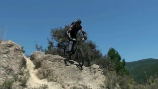
trail: Pas Eixedes
3:11 |
546 |
Feb 22, 2021 , Arles-sur-Tech
Recent Trail Reports
| status | trail | date | condition | info | user |
|---|---|---|---|---|---|
| suite descente Pas Eixedes | May 31, 2026 @ 11:40am (Europe/Andorra) May 31, 2026 | Dry | nicofsr | ||
| ⚡ Pas vertiginós de Bonabosc | May 17, 2026 @ 6:05pm (Europe/Paris) May 17, 2026 | Unknown | JulienAVoRmj | ||
| Pas Eixedes | Sep 2, 2025 @ 9:37am Sep 2, 2025 | Ideal | Tofito | ||
| Banabosc ⚡ | Sep 2, 2025 @ 9:37am Sep 2, 2025 | Ideal | Tofito | ||
| GR10 grande Batterie | Sep 19, 2024 @ 9:33am Sep 19, 2024 | Unknown | paco-jones | ||
| Pilo de Belmaig Versant NO | Sep 17, 2024 @ 10:47am Sep 17, 2024 | Very Dry | paco-jones | ||
| Belmaig | Sep 15, 2024 @ 1:43pm Sep 15, 2024 | Very Dry | paco-jones | ||
| Coll d'Ares UpHill | Jun 25, 2024 @ 1:36am Jun 25, 2024 | Ideal | Tofito | ||
| Pla de la Souque UpHill | Apr 13, 2024 @ 2:08am Apr 13, 2024 | Ideal | qfeger C&B | ||
| Chapelle Santa Engracia | Jan 7, 2024 @ 12:05am Jan 7, 2024 | Very Dry | Pyves |
Activity Feed
| username | action | type | title | date |
|---|---|---|---|---|
| UlGoe | ridden | trail | activity #97782955 | Jun 25, 2026 @ 11:40am Jun 25, 2026 |
| nicofsr | ridden | trail | activity #95924426 | May 31, 2026 @ 4:09am May 31, 2026 |
| nicofsr | add | report | activity #95924309 | May 31, 2026 @ 4:07am May 31, 2026 |
| JulienAVoRmj | add | report | activity #94910169 | May 17, 2026 @ 9:05am May 17, 2026 |
| JulienAVoRmj | ridden | trail | activity #94909908 | May 17, 2026 @ 9:03am May 17, 2026 |
Recent Comments
| username | type | title | comment | date |
|---|---|---|---|---|
| trail | Descente engagée surtout que l'on laisse des... | Aug 4, 2024 @ 6:44am Aug 4, 2024 | ||
| trail | access eternal but i think definitly worth to... | Jun 25, 2024 @ 8:40am Jun 25, 2024 | ||
| trail | Premier tiers pas super fun à rouler car... | Dec 15, 2023 @ 6:53am Dec 15, 2023 | ||
| trail | Le sentier est rouge. | Jul 9, 2023 @ 12:37am Jul 9, 2023 | ||
| trail | La descente est rouge. | Jul 8, 2023 @ 10:10am Jul 8, 2023 |
Local Badges
-

Epic Mountain Bike Climb 2k5 awarded -

Climbing 10k Badge0 awarded -

Mountain Biking 100k Badge0 awarded -

Epic Ride Descent 2k5 awarded -

Descent 10k Badge0 awarded -

Descent 100k Badge0 awarded
Activity Type Stats
| activitytype | trails | distance | descent | descent distance | total vertical | rating | global rank | state rank | photos | reports | routes | activity logs |
|---|---|---|---|---|---|---|---|---|---|---|---|---|
| Mountain Bike | 26 | 49 miles | 16,355 ft | 21 miles | 4,777 ft | #5,679 | #223 | 8 | 25 | 87 | ||
| E-Bike | 22 | 46 miles | 14,810 ft | 19 miles | 4,469 ft | #3,260 | #198 | 24 | 27 | |||
| Hike | 23 | 45 miles | 14,239 ft | 18 miles | 4,777 ft | #4,828 | #157 | 25 | 20 | |||
| Trail Running | 23 | 45 miles | 14,239 ft | 18 miles | 4,777 ft | #4,545 | #164 | 25 | 1 |
Frequently Asked Questions About Arles-sur-Tech
▼
What are the highest rated mountain biking trails in Arles-sur-Tech?
The highest rated mountain biking trails in Arles-sur-Tech are:
- Pilo de Belmaig Versant NO (4.2/5)
- Chapelle Santa Engracia (4.1/5)
- Chapelle Santa Engracia route de Montalba (4.1/5)
- suite descente Pas Eixedes (4.1/5)
- Montalba Amelie versant Nord (4.1/5)
▼
Where can I park to ride in Arles-sur-Tech?
There are 1 parking locations listed in Arles-sur-Tech. The most popular parking spots are:
▼
What is the longest trail in Arles-sur-Tech?
The longest trail in Arles-sur-Tech is Belmaig at 2.8 miles. View all trails sorted by distance.
▼
What are the best & highest rated hiking trails in Arles-sur-Tech?
The best hiking trails in Arles-sur-Tech are: View all hiking trails sorted by popularity score.
Activities
Trails
Points of Interest
- By JohnTraversin
 & contributors
 - Admins: provencemb, JohnTraversin
- #38987 - 1,237 views
- arles-sur-tech activity log | embed map of Arles-sur-Tech mountain bike trails | arles-sur-tech mountain biking points of interest
Downloading of trail gps tracks in kml & gpx formats is enabled for Arles-sur-Tech.
You must login to download files.