close
-
Layers w
- Weather Layers
- Pro
- Pro
- Pro
- Pro
- Pro
- Pro
- More Layers
- Pro
- Pro
- Pro
- Pro
-
Upgrade to

3D
Trail Conditions
- Unknown
- Snow Groomed
- Snow Packed
- Snow Covered
- Snow Cover Partial
- Freeze/thaw Cycle
- Icy
- Prevalent Mud
- Wet
- Variable
- Ideal
- Dry
- Very Dry
Trail Flow (Ridden Direction)
Trailforks scans users ridelogs to determine the most popular direction each trail is ridden. A good flowing trail network will have most trails flowing in a single direction according to their intension.
The colour categories are based on what percentage of riders are riding a trail in its intended direction.
The colour categories are based on what percentage of riders are riding a trail in its intended direction.
- > 96%
- > 90%
- > 80%
- > 70%
- > 50%
- < 50%
- bi-directional trail
- no data
Trail Last Ridden
Trailforks scans ridelogs to determine the last time a trail was ridden.
- < 2 days
- < 1 week
- < 2 weeks
- < 1 month
- < 6 months
- > 6 months
Trail Ridden Direction
The intended direction a trail should be ridden.
- Downhill Only
- Downhill Primary
- Both Directions
- Uphill Primary
- Uphill Only
- One Direction
Contribute Details
Colors indicate trail is missing specified detail.
- Description
- Photos
- Description & Photos
- Videos
Trail Popularity ?
Trailforks scans ridelogs to determine which trails are ridden the most in the last 9 months.
Trails are compared with nearby trails in the same city region with a possible 25 colour shades.
Think of this as a heatmap, more rides = more kinetic energy = warmer colors.
- most popular
- popular
- less popular
- not popular
ATV/ORV/OHV Filter
Max Vehicle Width
inches
US Cell Coverage
Legend

Radar Time
Activity Recordings
Trailforks uses anonymized public activity data.
?
Activity Recordings
Trailforks uses anonymized public activity data.
?
Personal Heatmap
▶
Activity Types
all
/
none
▶
Options
2
Date range
month
–
Winter Trails
Warning
A routing network for winter maps does not exist. Selecting trails using the winter trails layer has been disabled.
Missing Trails
Most Popular
Least Popular
Trails are colored based on popularity. The more popular a trail is, the more red. Less popular trails trend towards green.
Jump Magnitude Heatmap
Heatmap of where riders jump on trails. Zoom in to see individual jumps, click circles to view jump details.
BC Backroad Status
![map legend]()
Service Road Atlas is a free to use, community-driven service for viewing and creating reports on the numerous back-country service roads around B.C. and Alberta.

Slope Aspect
Direction the slope faces
Trails Deemphasized
Trails are shown in grey.
Only show trails with no bike usage.
Suggested Layers
Based on selected activity type
Save the current map location and zoom level as your default home location whenever this page is loaded.
Save
No description for Azuga has been added yet!
Login or register to submit one.
This region uses the Uk/Euro style trail grading system.
Activities Click to view
- Mountain Bike
12 trails
- E-Bike
11 trails
- Hike
10 trails
- Trail Running
10 trails
- Dirtbike/Moto
5 trails
Region Details
- 3
- 3
- 4
Region Status
Caution as of Jun 8, 2025Stats
- Avg Trail Rating
- Trails (view details)
- 11
- Trails Mountain Bike
- 12
- Trails E-Bike
- 11
- Trails Horse
- 1
- Trails Hike
- 10
- Trails Trail Running
- 10
- Trails Dirtbike/Moto
- 6
- Trails ATV/ORV/OHV
- 3
- Trails Snowmobile
- 2
- Total Distance
- 33 miles
- Total Descent Distance
- 25 miles
- Total Descent
- 14,188 ft
- Total Vertical
- 3,099 ft
- Highest Trailhead
- 6,178 ft
- Reports
- 44
- Photos
- 15
- Ridden Counter
- 469
Sub Regions
-
Azuga Mountain Bike Resort
- 2
- 1
Popular Azuga Mountain Biking Trails
• 60 ★ 5.0 • 4 miles • 67 ft • 78 •
Moderately popular green difficulty alpine mixed. This multi-use trail can be used downhill primary and has a moderate overall physical rating with a 67 ft blue climb. It features berm. Trail visibility is always easy to follow. On average it takes 19 minutes to complete this trail.
• 80 ★ 4.5 • 2 miles • 2 ft • 73 •
The trail is full of roots and in some sections quite steep. It is demanding if you go at speed.
• 5 ★ 3.0 • 4 miles • 51 ft • 3 •
Lots of ups and downs ,this is the hard part. Oh ..and lots of shepard dogs in the summer,best time to ride it is autumn.
• 5 ★ 3.0 • 1 mile • 0 ft • 3 •
Trail starts from sheepfold so watch out for dogs in the summer.
• 5 ★ 4.4 • 1 mile • 0 ft • 3 •
Not that hard, although is very steep (some places 45) .Lower parts in the woods easy to follow but not the same story when you come from Clabucetul Azugii, missing signs (blue stripe).
• 5 ★ 3.0 • 3 miles • 172 ft • 2 •
Watch out for dogs in the summer. Best time to go there is end of september.
Photos of Azuga Mountain Bike
Videos of Azuga Mountain Bike
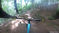
trail: Poteca Afinarilor
0:23 |
362 |
Sep 13, 2019
trail: Poteca Vulpilor
33:18 |
405 |
Oct 9, 2023 , Azuga

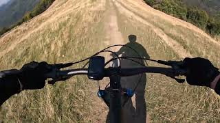
trail: Drumul Căruţaşilor
13:22 |
576 |
Mar 19, 2021 , Azuga
trail: Poteca Afinarilor
374 |
Oct 30, 2020 , Azuga

trail: Trout
25:21 |
331 |
Aug 31, 2020 , Azuga
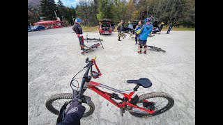
trail: Moto trail
8:13 |
241 |
Aug 31, 2020 , Azuga

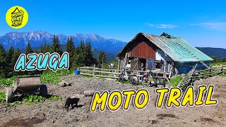
trail: Moto trail
15:55 |
225 |
Feb 3, 2020 , Azuga
trail: Trout
15:55 |
256 |
Jan 24, 2020 , Azuga
Recent Trail Reports
| status | trail | date | condition | info | user |
|---|---|---|---|---|---|
| Forestier Valea Grecului | Jun 8, 2025 @ 8:16am Jun 8, 2025 | Prevalent Mud | Mariuswfe5wI | ||
| Poteca Afinarilor | Oct 27, 2024 @ 10:45am Oct 27, 2024 | Dry | dragosss | ||
| Access to trail head | Oct 27, 2024 @ 10:45am Oct 27, 2024 | Ideal | dragosss | ||
| Trout | Aug 30, 2024 @ 1:24pm Aug 30, 2024 | Dry | cosminbg | ||
| Poteca Vulpilor | Oct 14, 2023 @ 1:32am Oct 14, 2023 | Wet | TransylvaniaFreerideTrails | ||
| Drumul Căruţaşilor | Jun 5, 2023 @ 12:08pm Jun 5, 2023 | Ideal | Andreeeea | ||
| Ceausescu | Aug 18, 2022 @ 10:01am Aug 18, 2022 | Prevalent Mud | steff-u | ||
| Culmea Baiului | Sep 9, 2021 @ 12:54am Sep 9, 2021 | Ideal | steff-u | ||
| Drumul lui Ceausescu spre clabucetul Azugii | Aug 1, 2021 @ 5:12am Aug 1, 2021 | Variable | steff-u |
Activity Feed
| username | action | type | title | date |
|---|---|---|---|---|
| CobraArtv6DXYA | ridden | trail | activity #97504655 | Jun 21, 2026 @ 11:25am 3 days |
| torpila | wishlist | trail | activity #96206348 and 3 more | Jun 3, 2026 @ 10:09pm Jun 3, 2026 |
| torpila | wishlist | trail | activity #96206334 and 1 more | Jun 3, 2026 @ 10:08pm Jun 3, 2026 |
| Cip24rian | wishlist | trail | activity #89448867 and 5 more | Feb 23, 2026 @ 11:02pm Feb 23, 2026 |
| Cip24rian | wishlist | trail | activity #89448861 and 2 more | Feb 23, 2026 @ 11:02pm Feb 23, 2026 |
Recent Comments
| username | type | title | comment | date |
|---|---|---|---|---|
| trail | Great fun. Really steep but can be ridden... | Aug 30, 2024 @ 1:26pm Aug 30, 2024 | ||
| trail | Great trail, quite steep, testing your balls,... | Sep 10, 2023 @ 10:09pm Sep 10, 2023 |
Local Badges
-

Epic Mountain Bike Climb 2k89 awarded -

Climbing 10k Badge4 awarded -

Mountain Biking 100k Badge0 awarded -

Epic Ride Descent 2k89 awarded -

Descent 10k Badge9 awarded -

Descent 100k Badge0 awarded
Bike & Skill Parks
| name | type | city | rating |
|---|---|---|---|
| Azuga Mountain Bike Resort | bike park | Azuga | |
| Azuga Skill park | skill park | Azuga |
Local Trail Supporters
- Richea Vasile
Activity Type Stats
| activitytype | trails | distance | descent | descent distance | total vertical | rating | global rank | state rank | photos | reports | routes | ridelogs |
|---|---|---|---|---|---|---|---|---|---|---|---|---|
| Mountain Bike | 12 | 33 miles | 14,190 ft | 25 miles | 3,100 ft | #3,262 | #16 | 15 | 44 | 482 | ||
| E-Bike | 11 | 32 miles | 13,543 ft | 24 miles | 3,100 ft | #1,388 | #29 | 44 | 125 | |||
| Horse | 1 | 4 miles | 1,952 ft | 3 miles | 1,883 ft | 6 | ||||||
| Hike | 10 | 30 miles | 12,333 ft | 22 miles | 3,100 ft | #2,775 | #21 | 44 | 65 | |||
| Trail Running | 10 | 30 miles | 12,333 ft | 22 miles | 3,100 ft | #587 | #11 | 43 | 13 | |||
| Dirtbike/Moto | 5 | 21 miles | 8,087 ft | 15 miles | 2,736 ft | #235 | #4 | 3 | ||||
| ATV/ORV/OHV | 3 | 8 miles | 3,694 ft | 7 miles | 2,392 ft | 2 | ||||||
| Snowmobile | 2 | 7 miles | 2,707 ft | 6 miles | 1,867 ft |
Frequently Asked Questions About Azuga
▼
What are the best places to ride in Azuga?
Azuga has 1 areas to explore for mountain biking. The top rated areas are:
▼
What are the highest rated mountain biking trails in Azuga?
The highest rated mountain biking trails in Azuga are:
- Drumul Căruţaşilor (4.3/5)
- Poteca Afinarilor (4.2/5)
- Poteca Vulpilor (4/5)
- Trout (4/5)
- Ceausescu (3.7/5)
▼
What is the best time of the year to ride in Azuga?
Based on ride log data, the most popular months to ride in Azuga are:
- July (12 activities)
- June (5 activities)
- August (4 activities)
▼
Where can I park to ride in Azuga?
Check the Azuga trail map for trailhead and parking information. Community members regularly update access and parking details for trails in the area.
Activities
Trails
Points of Interest
- By SurmontClub
 Surmont & contributors
 - Admins: pufalot
- #23100 - 4,521 views
- azuga activity log | embed map of Azuga mountain bike trails | azuga mountain biking points of interest
Downloading of trail gps tracks in kml & gpx formats is enabled for Azuga.
You must login to download files.