close
-
Layers w
- Weather Layers
- Pro
- Pro
- Pro
- Pro
- Pro
- Pro
- More Layers
- Pro
- Pro
- Pro
- Pro
-
Upgrade to

3D
Trail Conditions
- Unknown
- Snow Groomed
- Snow Packed
- Snow Covered
- Snow Cover Partial
- Freeze/thaw Cycle
- Icy
- Prevalent Mud
- Wet
- Variable
- Ideal
- Dry
- Very Dry
Trail Flow (Ridden Direction)
Trailforks scans users ridelogs to determine the most popular direction each trail is ridden. A good flowing trail network will have most trails flowing in a single direction according to their intension.
The colour categories are based on what percentage of riders are riding a trail in its intended direction.
The colour categories are based on what percentage of riders are riding a trail in its intended direction.
- > 96%
- > 90%
- > 80%
- > 70%
- > 50%
- < 50%
- bi-directional trail
- no data
Trail Last Ridden
Trailforks scans ridelogs to determine the last time a trail was ridden.
- < 2 days
- < 1 week
- < 2 weeks
- < 1 month
- < 6 months
- > 6 months
Trail Ridden Direction
The intended direction a trail should be ridden.
- Downhill Only
- Downhill Primary
- Both Directions
- Uphill Primary
- Uphill Only
- One Direction
Contribute Details
Colors indicate trail is missing specified detail.
- Description
- Photos
- Description & Photos
- Videos
Trail Popularity ?
Trailforks scans ridelogs to determine which trails are ridden the most in the last 9 months.
Trails are compared with nearby trails in the same city region with a possible 25 colour shades.
Think of this as a heatmap, more rides = more kinetic energy = warmer colors.
- most popular
- popular
- less popular
- not popular
ATV/ORV/OHV Filter
Max Vehicle Width
inches
US Cell Coverage
Legend

Radar Time
Activity Recordings
Trailforks uses anonymized public activity data.
?
Activity Recordings
Trailforks uses anonymized public activity data.
?
Personal Heatmap
▶
Activity Types
all
/
none
▶
Options
2
Date range
month
–
Winter Trails
Warning
A routing network for winter maps does not exist. Selecting trails using the winter trails layer has been disabled.
Missing Trails
Most Popular
Least Popular
Trails are colored based on popularity. The more popular a trail is, the more red. Less popular trails trend towards green.
Jump Magnitude Heatmap
Heatmap of where riders jump on trails. Zoom in to see individual jumps, click circles to view jump details.
BC Backroad Status
![map legend]()
Service Road Atlas is a free to use, community-driven service for viewing and creating reports on the numerous back-country service roads around B.C. and Alberta.

Slope Aspect
Direction the slope faces
Trails Deemphasized
Trails are shown in grey.
Only show trails with no bike usage.
Suggested Layers
Based on selected activity type
Save the current map location and zoom level as your default home location whenever this page is loaded.
Save
No description for Bailey has been added yet!
Login or register to submit one.
Activities Click to view
- Mountain Bike
4 trails
- Horse
15 trails
- Hike
24 trails
- Trail Running
23 trails
Region Details
- 1
- 2
- 1
Region Status
Open as of Jun 21, 2024Stats
- Trails (view details)
- 22
- Trails Mountain Bike
- 4
- Trails Horse
- 15
- Trails Hike
- 24
- Trails Trail Running
- 23
- Total Distance
- 138 miles
- Total Descent
- 33,770 ft
- Total Vertical
- 4,528 ft
- Highest Trailhead
- 12,406 ft
- Reports
- 12
- Photos
- 12
- Ridden Counter
- 689
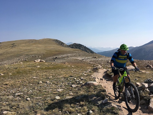
Popular Bailey Mountain Biking Trails
• ★ 0.0 • 896 ft • 0 ft • 5 • • hike
Blue difficulty singletrack. This hike primary trail can be used both directions. On average it takes minutes to complete this trail.
• ★ 0.0 • 2 miles • 103 ft • 4 • • hike
Blue difficulty singletrack. This hike primary trail can be used both directions. On average it takes 16 minutes to complete this trail.
• ★ 0.0 • 6 miles • 1,448 ft • • hike
Black diamond difficulty singletrack. This hike primary trail can be used both directions. Trail visibility is sometimes hard to follow.
Bailey Mountain Bike Routes
7 miles • 1,427 ft • 2 • Loop •
Route rides best clockwise, starting at the Bruno campground area. Counterclockwise requires some longer...
39 miles • 3,856 ft • 9 • Point to Point •
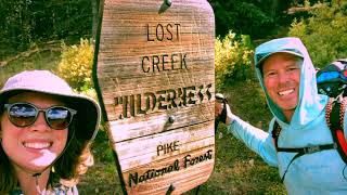
Ride the Colorado Trail from the Lost Creek Wilderness closure all the way to Denver. Don't forget that...
69 miles • 8,041 ft • 0 •
Colorado Trail Lost Creek Wilderness Detour
★ 5.0 • 62 miles • 8,020 ft • 10 • Loop • Race •
2025 Bailey Hundo Course!!!!!!!!!!!!!!!!!!!!
Photos of Bailey Mountain Bike
Videos of Bailey Mountain Bike
trail: Lost Creek Gulch Cutoff
3:03 |
174 |
Sep 23, 2021 , Bailey
Recent Trail Reports
| status | trail | date | condition | info | user |
|---|---|---|---|---|---|
| Bailey Hundo Private Trail Segment | Jun 19, 2021 @ 7:58am Jun 19, 2021 | Unknown | joehandlebar |
National Scenic Trails & Official Routes
-
Colorado Trail (Bike)
- Mountain Bike
Activity Feed
| username | action | type | title | date |
|---|---|---|---|---|
| BogarEA | wishlist | route | activity #96642460 | Jun 9, 2026 @ 5:42pm Jun 9, 2026 |
| rexman | vote | route | activity #94912556 | May 17, 2026 @ 9:27am May 17, 2026 |
| Priz2086 | wishlist | route | activity #94293491 | May 8, 2026 @ 5:45pm May 8, 2026 |
| TimmyGG | wishlist | route | activity #92768364 | Apr 16, 2026 @ 9:13pm Apr 16, 2026 |
| AndreyD1ZlE | wishlist | trail | activity #92336446 | Apr 10, 2026 @ 12:17pm Apr 10, 2026 |
Local Badges
-

Epic Ride Climb 2k20 awarded -

Climbing 10k Badge2 awarded -

Climbing 100k Badge0 awarded -

Epic Ride Descent 2k20 awarded -

Descent 10k Badge2 awarded -

Descent 100k Badge0 awarded
Activity Type Stats
| activitytype | trails | distance | descent | descent distance | total vertical | rating | global rank | state rank | photos | reports | routes | ridelogs |
|---|---|---|---|---|---|---|---|---|---|---|---|---|
| Mountain Bike | 4 | 11 miles | 1,775 ft | 5 miles | 3,133 ft | #13,373 | #4,067 | 1 | 11 | 2 | 570 | |
| Horse | 15 | 90 miles | 20,938 ft | 45 miles | 3,806 ft | #802 | #586 | 7 | 1 | |||
| Hike | 24 | 138 miles | 33,770 ft | 70 miles | 4,528 ft | #1,214 | #558 | 12 | 12 | 2 | 1,128 | |
| Trail Running | 23 | 137 miles | 33,753 ft | 70 miles | 3,990 ft | #1,677 | #567 | 12 | 1 | 38 |
Frequently Asked Questions About Bailey
▼
What are the best places to ride in Bailey?
Bailey has 1 areas to explore for mountain biking.
▼
What are the highest rated mountain biking trails in Bailey?
The highest rated mountain biking trails in Bailey are:
- Long Gulch Trailhead (0/5)
- Brookside - McCurdy (Lost Park) (0/5)
- Nate Stultz (0/5)
▼
What is the best time of the year to ride in Bailey?
Based on ride log data, the most popular months to ride in Bailey are:
- July (25 activities)
- June (13 activities)
- May (9 activities)
▼
Where can I park to ride in Bailey?
There are 12 parking locations listed in Bailey. The most popular parking spots are: View all parking and trailhead locations on the map to plan your visit.
Trails
- By todd
 Trailforks & contributors
 - Admins: apply
- #22207 - 3,502 views
- bailey activity log | embed map of Bailey mountain bike trails | bailey mountain biking points of interest
Downloading of trail gps tracks in kml & gpx formats is enabled for Bailey.
You must login to download files.