close
-
Layers w
- Weather Layers
- Pro
- Pro
- Pro
- Pro
- Pro
- Pro
- More Layers
- Pro
- Pro
- Pro
- Pro
-
Upgrade to

3D
Trail Conditions
- Unknown
- Snow Groomed
- Snow Packed
- Snow Covered
- Snow Cover Partial
- Freeze/thaw Cycle
- Icy
- Prevalent Mud
- Wet
- Variable
- Ideal
- Dry
- Very Dry
Trail Flow (Ridden Direction)
Trailforks scans users ridelogs to determine the most popular direction each trail is ridden. A good flowing trail network will have most trails flowing in a single direction according to their intension.
The colour categories are based on what percentage of riders are riding a trail in its intended direction.
The colour categories are based on what percentage of riders are riding a trail in its intended direction.
- > 96%
- > 90%
- > 80%
- > 70%
- > 50%
- < 50%
- bi-directional trail
- no data
Trail Last Ridden
Trailforks scans ridelogs to determine the last time a trail was ridden.
- < 2 days
- < 1 week
- < 2 weeks
- < 1 month
- < 6 months
- > 6 months
Trail Ridden Direction
The intended direction a trail should be ridden.
- Downhill Only
- Downhill Primary
- Both Directions
- Uphill Primary
- Uphill Only
- One Direction
Contribute Details
Colors indicate trail is missing specified detail.
- Description
- Photos
- Description & Photos
- Videos
Trail Popularity ?
Trailforks scans ridelogs to determine which trails are ridden the most in the last 9 months.
Trails are compared with nearby trails in the same city region with a possible 25 colour shades.
Think of this as a heatmap, more rides = more kinetic energy = warmer colors.
- most popular
- popular
- less popular
- not popular
ATV/ORV/OHV Filter
Max Vehicle Width
inches
US Cell Coverage
Legend

Radar Time
Activity Recordings
Trailforks uses anonymized public activity data.
?
Activity Recordings
Trailforks uses anonymized public activity data.
?
Personal Heatmap
▶
Activity Types
all
/
none
▶
Options
2
Date range
month
–
Winter Trails
Warning
A routing network for winter maps does not exist. Selecting trails using the winter trails layer has been disabled.
Missing Trails
Most Popular
Least Popular
Trails are colored based on popularity. The more popular a trail is, the more red. Less popular trails trend towards green.
Jump Magnitude Heatmap
Heatmap of where riders jump on trails. Zoom in to see individual jumps, click circles to view jump details.
BC Backroad Status
![map legend]()
Service Road Atlas is a free to use, community-driven service for viewing and creating reports on the numerous back-country service roads around B.C. and Alberta.

Slope Aspect
Direction the slope faces
Trails Deemphasized
Trails are shown in grey.
Only show trails with no bike usage.
Suggested Layers
Based on selected activity type
Save the current map location and zoom level as your default home location whenever this page is loaded.
Save
No description for Balloch has been added yet!
Login or register to submit one.
This region uses the Uk/Euro style trail grading system.
Activities Click to view
- Mountain Bike
8 trails
- Adaptive Bike
0 trails
- Hike
5 trails
- Trail Running
5 trails
Region Details
- 3
- 1
- 2
- 2
Region Status
Open as of Dec 28, 2025Stats
- Avg Trail Rating
- Trails (view details)
- 8
- Trails Mountain Bike
- 8
- Trails E-Bike
- 3
- Trails Hike
- 5
- Trails Trail Running
- 5
- Total Distance
- 4 miles
- Total Descent
- 1,337 ft
- Total Vertical
- 860 ft
- Highest Trailhead
- 915 ft
- Reports
- 34
- Photos
- 23
- Ridden Counter
- 244
Popular Balloch Mountain Biking Trails
• 100 ★ 1.5 • 4,853 ft • 0 ft • 42 •
Popular blue difficulty mixed. This mountain bike primary trail can be used downhill primary. On average it takes 5 minutes to complete this trail.
• 5 ★ 1.4 • 2,669 ft • 5 ft • 15 •
Flowing natural singletrack down through the woods with three skinny bridges to negotiate over some ditches. Some tight spots between trees. Rides well in the summer but best avoided during wet times to avoid erosion.
• 5 ★ 5.0 • 791 ft • 0 ft • 11 •
Starts with a right left off the jump line and has a small kicker into a chute. The kicker is not mandatory and can be ridden around. From there the trail goes left through some trees and on to a small technical descent onto a small...
Balloch Mountain Bike Routes
6 miles • 146 ft • 1 • Loop •
A loop around the Renton fish farm back to the Balloch canal path
3 miles • 146 ft • 0 • Loop •
Enjoy spectacular views of Loch Lomond in this beautiful country park in West Scotland. There are 200...
33 miles • 3,109 ft • 0 • Point to Point •
Three Lochs Way Balloch to Ardlui. Can be done in reverse.
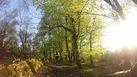
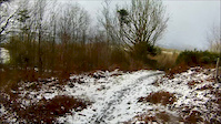
Photos of Balloch Mountain Bike
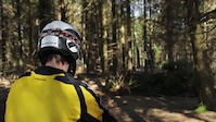
Videos of Balloch Mountain Bike
trail: Whinny Hill\Fairy Glen
4:44 |
203 |
May 10, 2016
trail: Whinny Hill\Fairy Glen
5:36 |
91 |
Jan 30, 2016
trail: Deer Trail
0:41 |
1253 |
Jun 5, 2013
Recent Trail Reports
| status | trail | date | condition | info | user |
|---|---|---|---|---|---|
| Strike It Lucky | Dec 28, 2025 @ 4:57pm (Europe/London) Dec 28, 2025 | Unknown | PHmotorsport | ||
| Betty Swallocks | Dec 28, 2025 @ 4:56pm (Europe/London) Dec 28, 2025 | Unknown | PHmotorsport | ||
| Fire Road / Path | May 25, 2025 @ 12:04pm May 25, 2025 | Variable | jacobrollinson155 | ||
| Deer Trail | Mar 6, 2022 @ 6:58am Mar 6, 2022 | Variable | garye-mtb | ||
| Whinny Hill\Fairy Glen | Jan 18, 2022 @ 5:49am Jan 18, 2022 | Variable | garye-mtb | ||
| Fire Road / Path | Jan 4, 2019 @ 4:43am Jan 4, 2019 | Wet | LetMeOut |
Activity Feed
| username | action | type | title | date |
|---|---|---|---|---|
| Walterfraser | add | route | activity #95529179 | May 25, 2026 @ 3:47pm May 25, 2026 |
| j6P5zg | comment | trail | activity #93706281 | Apr 30, 2026 @ 5:33am Apr 30, 2026 |
| PHmotorsport | add | report | activity #86216752 and 1 more | Dec 28, 2025 @ 8:56am Dec 28, 2025 |
| jacobrollinson155 | add | report | activity #72391796 | May 25, 2025 @ 12:04pm May 25, 2025 |
| jacobrollinson155 | ridden | trail | activity #72391680 | May 25, 2025 @ 12:02pm May 25, 2025 |
Recent Comments
| username | type | title | comment | date |
|---|---|---|---|---|
| trail | Lots of tree felling. Track inaccessible | Apr 30, 2026 @ 5:33am Apr 30, 2026 | ||
| trail | Sadly this now looks permanently closed. Some... | Jan 5, 2022 @ 1:05pm Jan 5, 2022 | ||
| trail | We have almost finished a big downhill called... | Apr 2, 2021 @ 2:33pm Apr 2, 2021 | ||
| trail | Great wee trail hopefully more like this to come | Mar 22, 2021 @ 5:06am Mar 22, 2021 | ||
| trail | Great trail, really tricky in the wet! Fast... | Mar 15, 2021 @ 3:14am Mar 15, 2021 |
Activity Type Stats
| activitytype | trails | distance | descent | descent distance | total vertical | rating | global rank | state rank | photos | reports | routes | ridelogs |
|---|---|---|---|---|---|---|---|---|---|---|---|---|
| Mountain Bike | 8 | 4 miles | 1,335 ft | 3 miles | 860 ft | #6,843 | #246 | 24 | 33 | 3 | 1,436 | |
| E-Bike | 3 | 1,362 ft | 197 ft | 1,152 ft | 154 ft | 16 | 3 | 184 | ||||
| Hike | 5 | 3 miles | 1,142 ft | 2 miles | 502 ft | #11,158 | #387 | 27 | 1 | 94 | ||
| Trail Running | 5 | 3 miles | 1,142 ft | 2 miles | 502 ft | #10,578 | #376 | 27 | 1 | 62 |
Frequently Asked Questions About Balloch
▼
What are the highest rated mountain biking trails in Balloch?
The highest rated mountain biking trails in Balloch are:
- Strike It Lucky (4.2/5)
- Access Trail (4.1/5)
- Betty Swallocks (4.1/5)
- Whinny Hill\Fairy Glen (3.4/5)
- Deer Trail (3.1/5)
▼
What is the best time of the year to ride in Balloch?
Based on ride log data, the most popular months to ride in Balloch are:
- July (24 activities)
- April (17 activities)
- June (16 activities)
▼
Where can I park to ride in Balloch?
Check the Balloch trail map for trailhead and parking information. Community members regularly update access and parking details for trails in the area.
▼
What is the longest trail in Balloch?
The longest trail in Balloch is Whinny Hill\Fairy Glen at 4,853 ft. View all trails sorted by distance.
- By jechydda & contributors
- Admins: DMBinS, FLS
- #20160 - 3,988 views
- balloch activity log | embed map of Balloch mountain bike trails |
Downloading of trail gps tracks in kml & gpx formats is enabled for Balloch.
You must login to download files.