close
-
Layers w
- Weather Layers
- Pro
- Pro
- Pro
- Pro
- Pro
- Pro
- More Layers
- Pro
- Pro
- Pro
- Pro
-
Upgrade to

3D
Trail Conditions
- Unknown
- Snow Groomed
- Snow Packed
- Snow Covered
- Snow Cover Partial
- Freeze/thaw Cycle
- Icy
- Prevalent Mud
- Wet
- Variable
- Ideal
- Dry
- Very Dry
Trail Flow (Ridden Direction)
Trailforks scans users ridelogs to determine the most popular direction each trail is ridden. A good flowing trail network will have most trails flowing in a single direction according to their intension.
The colour categories are based on what percentage of riders are riding a trail in its intended direction.
The colour categories are based on what percentage of riders are riding a trail in its intended direction.
- > 96%
- > 90%
- > 80%
- > 70%
- > 50%
- < 50%
- bi-directional trail
- no data
Trail Last Ridden
Trailforks scans ridelogs to determine the last time a trail was ridden.
- < 2 days
- < 1 week
- < 2 weeks
- < 1 month
- < 6 months
- > 6 months
Trail Ridden Direction
The intended direction a trail should be ridden.
- Downhill Only
- Downhill Primary
- Both Directions
- Uphill Primary
- Uphill Only
- One Direction
Contribute Details
Colors indicate trail is missing specified detail.
- Description
- Photos
- Description & Photos
- Videos
Trail Popularity ?
Trailforks scans ridelogs to determine which trails are ridden the most in the last 9 months.
Trails are compared with nearby trails in the same city region with a possible 25 colour shades.
Think of this as a heatmap, more rides = more kinetic energy = warmer colors.
- most popular
- popular
- less popular
- not popular
ATV/ORV/OHV Filter
Max Vehicle Width
inches
US Cell Coverage
Legend

Radar Time
Activity Recordings
Trailforks uses anonymized public activity data.
?
Activity Recordings
Trailforks uses anonymized public activity data.
?
Personal Heatmap
▶
Activity Types
all
/
none
▶
Options
2
Date range
month
–
Winter Trails
Warning
A routing network for winter maps does not exist. Selecting trails using the winter trails layer has been disabled.
Missing Trails
Most Popular
Least Popular
Trails are colored based on popularity. The more popular a trail is, the more red. Less popular trails trend towards green.
Jump Magnitude Heatmap
Heatmap of where riders jump on trails. Zoom in to see individual jumps, click circles to view jump details.
BC Backroad Status
![map legend]()
Service Road Atlas is a free to use, community-driven service for viewing and creating reports on the numerous back-country service roads around B.C. and Alberta.

Slope Aspect
Direction the slope faces
Trails Deemphasized
Trails are shown in grey.
Only show trails with no bike usage.
Suggested Layers
Based on selected activity type
Save the current map location and zoom level as your default home location whenever this page is loaded.
Save
No description for Bäretswil has been added yet!
Login or register to submit one.
This region uses the Uk/Euro style trail grading system.
Activities Click to view
- Mountain Bike
33 trails
- E-Bike
30 trails
- Hike
33 trails
- Trail Running
33 trails
Region Details
- 8
- 6
- 15
- 3
- 1
Region Status
Open as of May 23, 2026Stats
- Avg Trail Rating
- Trails (view details)
- 33
- Trails Mountain Bike
- 33
- Trails E-Bike
- 30
- Trails Hike
- 33
- Trails Trail Running
- 33
- Total Distance
- 15 miles
- Total Descent Distance
- 10 miles
- Total Descent
- 5,773 ft
- Total Vertical
- 1,299 ft
- Highest Trailhead
- 3,369 ft
- Reports
- 114
- Photos
- 12
- Ridden Counter
- 1,271
Sub Regions
-
Rosinli Stoffel
- 5
- 8
- 1
- 1
Popular Bäretswil Mountain Biking Trails
• 85 ★ 4.2 • 4,186 ft • 8 ft • 87 •
Popular blue difficulty singletrack. This multi-use trail can be used downhill primary and has a moderate overall physical rating with a 8 ft black diamond climb. Trail visibility is always easy to follow. On average it takes 8 minutes to complete this trail.
• 50 ★ 4.5 • 3,504 ft • 0 ft • 67 •
Moderately popular blue difficulty singletrack. This multi-use trail can be used both directions. On average it takes 4 minutes to complete this trail.
• 35 ★ 4.0 • 2,211 ft • 31 ft • 64 •
Less popular blue difficulty singletrack. This multi-use trail can be used both directions. On average it takes 2 minutes to complete this trail.
• 100 ★ 3.0 • 3,350 ft • 19 ft • 49 • • hike
Popular blue difficulty singletrack. This hike primary trail can be used both directions. On average it takes 7 minutes to complete this trail.
• 65 ★ 4.0 • 2,963 ft • 17 ft • 43 •
Moderately popular blue difficulty singletrack. This multi-use trail can be used downhill primary. On average it takes 4 minutes to complete this trail.
• 20 ★ 3.5 • 3,202 ft • 6 ft • 42 • • hike
Less popular green difficulty singletrack. This hike primary trail can be used downhill primary and has a easy overall physical rating with a 6 ft blue climb. On average it takes 5 minutes to complete this trail.
• 85 ★ 0.0 • 2,205 ft • 46 ft • 40 •
Popular blue difficulty singletrack. This multi-use trail can be used downhill primary. On average it takes 2 minutes to complete this trail.
• 60 ★ 4.0 • 3,556 ft • 198 ft • 31 •
Moderately popular blue difficulty singletrack. This multi-use trail can be used downhill primary. Trail visibility is always easy to follow. On average it takes 10 minutes to complete this trail.
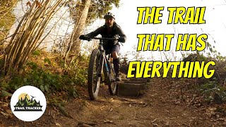
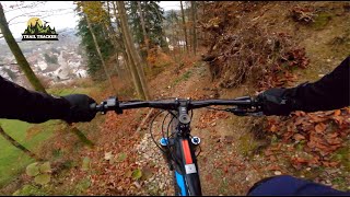
Photos of Bäretswil Mountain Bike
Videos of Bäretswil Mountain Bike
trail: Aabach
4:16 |
344 |
Sep 6, 2020 , Bäretswil
youtuber
![MTB Trails Switzerland - Zürcher Oberland...]()

trail: Obisbächli
4:16 |
275 |
Sep 6, 2020 , Bäretswil

trail: Neuthal - Hinterburg
4:42 |
239 |
Sep 6, 2020 , Bäretswil
youtuber
![MTB Trails Switzerland - Zürcher Oberland...]()
trail: Greifenberg
4:42 |
262 |
Sep 6, 2020 , Bäretswil
trail: Stoffel-Trail
8:08 |
745 |
Dec 29, 2019 , Bäretswil
youtuber
![MTB Trails Switzerland - Zürcher Oberland...]()

trail: Stoffel-Trail
8:08 |
971 |
Dec 29, 2019 , Bäretswil
Recent Trail Reports
| status | trail | date | condition | info | user |
|---|---|---|---|---|---|
| Chämtnertobel | May 23, 2026 @ 10:36am (Europe/Zurich) May 23, 2026 | Ideal | meikl | ||
| Pumpwerk Connector | May 23, 2026 @ 10:36am (Europe/Zurich) May 23, 2026 | Ideal | meikl | ||
| Rüteliholz | May 23, 2026 @ 10:36am (Europe/Zurich) May 23, 2026 | Ideal | meikl | ||
| Aabach | May 23, 2026 @ 10:36am (Europe/Zurich) May 23, 2026 | Ideal | meikl | ||
| Obisbächli | May 23, 2026 @ 10:36am (Europe/Zurich) May 23, 2026 | Ideal | meikl | ||
| Laubfelsenstrasse | Apr 21, 2026 @ 6:03pm (Europe/Zurich) Apr 21, 2026 | Ideal | stefanzumbrunn | ||
| Greifenberg direkt | Apr 21, 2026 @ 6:03pm (Europe/Zurich) Apr 21, 2026 | Ideal | stefanzumbrunn | ||
| Stoffel-Trail | Apr 21, 2026 @ 6:03pm (Europe/Zurich) Apr 21, 2026 | Ideal | stefanzumbrunn | ||
| Herenloch | Apr 21, 2026 @ 6:03pm (Europe/Zurich) Apr 21, 2026 | Ideal | stefanzumbrunn | ||
| Mööri | Apr 21, 2026 @ 6:03pm (Europe/Zurich) Apr 21, 2026 | Ideal | stefanzumbrunn |
Activity Feed
| username | action | type | title | date |
|---|---|---|---|---|
| meikl | add | report | activity #95306436 and 4 more | May 23, 2026 @ 5:07am May 23, 2026 |
| 0kommanix | wishlist | trail | activity #93723509 | Apr 30, 2026 @ 10:57am Apr 30, 2026 |
| DanielZTEtmW | difficultyvote | trail | activity #93344593 | Apr 25, 2026 @ 5:15am Apr 25, 2026 |
| stefanzumbrunn | add | report | activity #93103449 and 3 more | Apr 21, 2026 @ 1:42pm Apr 21, 2026 |
| stefanzumbrunn | add | report | activity #93103447 and 2 more | Apr 21, 2026 @ 1:42pm Apr 21, 2026 |
Recent Comments
| username | type | title | comment | date |
|---|---|---|---|---|
| trail | ridden it from höhenegg. dont ride down the... | May 18, 2025 @ 9:32am May 18, 2025 | ||
| trail | the trail is fun some very difficult spots.... | May 18, 2025 @ 9:29am May 18, 2025 | ||
| trail | hikers look out! | May 6, 2025 @ 12:17am May 6, 2025 | ||
| trail | fun trail. extremly wet. one spot its easier... | May 6, 2025 @ 12:16am May 6, 2025 | ||
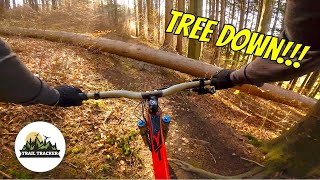
| trail | theirs some fallen tree blocking the trail... | May 6, 2025 @ 12:14am May 6, 2025 |
Local Badges
-

Epic Mountain Bike Climb 2k7 awarded -

Climbing 10k Badge4 awarded -

Mountain Biking 100k Badge0 awarded -

Epic Ride Descent 2k7 awarded -

Descent 10k Badge4 awarded -

Descent 100k Badge0 awarded
Activity Type Stats
| activitytype | trails | distance | descent | descent distance | total vertical | rating | global rank | state rank | photos | reports | routes | ridelogs |
|---|---|---|---|---|---|---|---|---|---|---|---|---|
| Mountain Bike | 33 | 15 miles | 5,771 ft | 10 miles | 1,299 ft | #5,827 | #148 | 12 | 112 | 1,271 | ||
| E-Bike | 30 | 14 miles | 5,623 ft | 9 miles | 1,299 ft | #4,573 | #191 | 107 | 136 | |||
| Hike | 33 | 15 miles | 5,771 ft | 10 miles | 1,299 ft | #7,072 | #191 | 111 | 32 | |||
| Trail Running | 33 | 15 miles | 5,771 ft | 10 miles | 1,299 ft | #6,689 | #171 | 111 | 32 |
Frequently Asked Questions About Bäretswil
▼
What are the best places to ride in Bäretswil?
Bäretswil has 1 areas to explore for mountain biking. The top rated areas are:
▼
What are the highest rated mountain biking trails in Bäretswil?
The highest rated mountain biking trails in Bäretswil are:
- ob Luppmenweier (4.1/5)
- Greifenberg direkt (4.1/5)
- Aabach (4.1/5)
- Stoffel-Trail (4.1/5)
- Obisbächli (4/5)
▼
What is the best time of the year to ride in Bäretswil?
Based on ride log data, the most popular months to ride in Bäretswil are:
- July (5 activities)
- September (2 activities)
- December (2 activities)
▼
Where can I park to ride in Bäretswil?
There are 1 parking locations listed in Bäretswil. The most popular parking spots are:
Activities
Trails
Points of Interest
- By joeldangelone
 & contributors
 - Admins: Zürich, ZO-Biketrails
- #14811 - 2,181 views
- bäretswil activity log | embed map of Bäretswil mountain bike trails | bäretswil mountain biking points of interest
Downloading of trail gps tracks in kml & gpx formats is enabled for Bäretswil.
You must login to download files.