close
-
Layers w
- Weather Layers
- Pro
- Pro
- Pro
- Pro
- Pro
- Pro
- More Layers
- Pro
- Pro
- Pro
- Pro
-
Upgrade to

3D
Trail Conditions
- Unknown
- Snow Groomed
- Snow Packed
- Snow Covered
- Snow Cover Partial
- Freeze/thaw Cycle
- Icy
- Prevalent Mud
- Wet
- Variable
- Ideal
- Dry
- Very Dry
Trail Flow (Ridden Direction)
Trailforks scans users activity logs to determine the most popular direction each trail is ridden. A good flowing trail network will have most trails flowing in a single direction according to their intension.
The colour categories are based on what percentage of users are riding a trail in its intended direction.
The colour categories are based on what percentage of users are riding a trail in its intended direction.
- > 96%
- > 90%
- > 80%
- > 70%
- > 50%
- < 50%
- bi-directional trail
- no data
Trail Last Ridden
Trailforks scans activity logs to determine the last time a trail was ridden.
- < 2 days
- < 1 week
- < 2 weeks
- < 1 month
- < 6 months
- > 6 months
Trail Ridden Direction
The intended direction a trail should be ridden.
- Downhill Only
- Downhill Primary
- Both Directions
- Uphill Primary
- Uphill Only
- One Direction
Contribute Details
Colors indicate trail is missing specified detail.
- Description
- Photos
- Description & Photos
- Videos
Trail Popularity ?
Trailforks scans activity logs to determine which trails are ridden the most in the last 9 months.
Trails are compared with nearby trails in the same city region with a possible 25 colour shades.
Think of this as a heatmap, more activities = more kinetic energy = warmer colors.
- most popular
- popular
- less popular
- not popular
ATV/ORV/OHV Filter
Max Vehicle Width
inches
US Cell Coverage
Legend

Radar Time
Activity Recordings
Trailforks uses anonymized public activity data.
?
Activity Recordings
Trailforks uses anonymized public activity data.
?
Personal Heatmap
▶
Activity Types
all
/
none
▶
Options
2
Date range
month
–
Winter Trails
Warning
A routing network for winter maps does not exist. Selecting trails using the winter trails layer has been disabled.
Missing Trails
Most Popular
Least Popular
Trails are colored based on popularity. The more popular a trail is, the more red. Less popular trails trend towards green.
Jump Magnitude Heatmap
Heatmap of where users jump on trails. Zoom in to see individual jumps, click circles to view jump details.
BC Backroad Status
![map legend]()
Service Road Atlas is a free to use, community-driven service for viewing and creating reports on the numerous back-country service roads around B.C. and Alberta.

Slope Aspect
Direction the slope faces
Trails Deemphasized
Trails are shown in grey.
Only show trails with no bike usage.
Suggested Layers
Based on selected activity type
Save the current map location and zoom level as your default home location whenever this page is loaded.
Save
No description for Bauma has been added yet!
Login or register to submit one.
This region uses the Uk/Euro style trail grading system.
Activities Click to view
- Mountain Bike
16 trails
- E-Bike
14 trails
- Hike
16 trails
- Trail Running
16 trails
Region Details
- 5
- 10
- 1
Region Status
Open as of Jul 22, 2026Stats
- Avg Trail Rating
- Trails (view details)
- 16
- Trails Mountain Bike
- 16
- Trails E-Bike
- 14
- Trails Hike
- 16
- Trails Trail Running
- 16
- Total Distance
- 6 miles
- Total Descent Distance
- 5 miles
- Total Descent
- 4,568 ft
- Total Vertical
- 1,592 ft
- Highest Trailhead
- 3,680 ft
- Reports
- 45
- Photos
- 18
- Completed Counter
- 529
Popular Bauma Mountain Biking Trails
• 100 ★ 3.5 • 3,497 ft • 194 ft • 59 •
Popular green difficulty singletrack. This multi-use trail can be used both directions. On average it takes 3 minutes to complete this trail.
• 85 ★ 4.4 • 4,721 ft • 20 ft • 43 •
Popular blue difficulty singletrack. This multi-use trail can be used downhill primary. On average it takes 7 minutes to complete this trail.
• 70 ★ 4.0 • 4,882 ft • 68 ft • 38 •
Popular red difficulty singletrack. This multi-use trail can be used both directions. On average it takes 29 minutes to complete this trail.
• 65 ★ 3.0 • 1,709 ft • 10 ft • 32 •
Moderately popular blue difficulty singletrack. This multi-use trail can be used downhill primary. On average it takes 2 minutes to complete this trail.
• 90 ★ 3.0 • 1,762 ft • 19 ft • 29 •
Popular blue difficulty singletrack. This multi-use trail can be used downhill primary. On average it takes 1 minutes to complete this trail.
• 95 ★ 0.0 • 673 ft • 3 ft • 28 •
Popular green difficulty singletrack. This multi-use trail can be used downhill primary. On average it takes minutes to complete this trail.
• 35 ★ 3.0 • 2,503 ft • 24 ft • 22 •
Less popular blue difficulty singletrack. This multi-use trail can be used both directions. On average it takes 2 minutes to complete this trail.
• 15 ★ 4.0 • 2,011 ft • 0 ft • 20 •
Less popular blue difficulty singletrack. This multi-use trail can be used both directions. On average it takes 2 minutes to complete this trail.
Photos of Bauma Mountain Bike
Videos of Bauma Mountain Bike
youtuber
![Camera upgrades pay off]()
trail: Hörnli-Heiletsegg
5:50 |
170 |
Apr 1, 2025 , Bauma
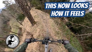
youtuber
![Getting fit on the Hörnli (MTB Zürcher Oberland)]()
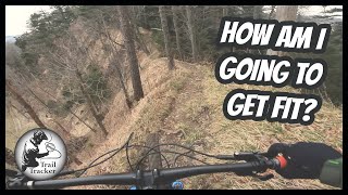
trail: Hörnli-Heiletsegg
7:41 |
216 |
Mar 16, 2023 , Bauma
youtuber
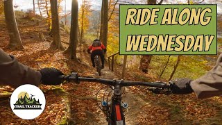
![Ride Along Wednesday - Chämmerli &...]()
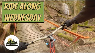
trail: Raggenhorn
5:58 |
172 |
Mar 17, 2020 , Bauma
trail: Silisegg - Neuthal
4:42 |
292 |
Sep 6, 2020 , Bauma
trail: Lower Altlandenberg
3:13 |
356 |
Apr 2, 2020 , Bauma
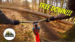
youtuber
![Ride Along Wednesday - Altlandenberg RAW]()

trail: Upper Altlandenberg
3:13 |
309 |
Apr 2, 2020 , Bauma

trail: Lower Altlandenberg
5:05 |
295 |
Jan 16, 2020 , Bauma
trail: Upper Altlandenberg
5:05 |
247 |
Jan 16, 2020 , Bauma
Recent Trail Reports
| status | trail | date | condition | info | user |
|---|---|---|---|---|---|
| Schindlet Hunds-Chilen Bauma | Jul 22, 2026 @ 11:20pm (Europe/Zurich) Jul 22, 2026 | Dry | schnuri42 | ||
| Silisegg - Neuthal | Jul 8, 2026 @ 5:21pm (Europe/Zurich) Jul 8, 2026 | Ideal | fempel | ||
| Hörnli-Heiletsegg | Mar 22, 2026 @ 7:30pm (Europe/Zurich) Mar 22, 2026 | Ideal | svadi | ||
| Stoffelweg-Bauma | May 18, 2025 @ 1:54pm May 18, 2025 | Ideal | whitepawn93 | ||
| Stoffelweg-Bliggenswil | May 18, 2025 @ 1:54pm May 18, 2025 | Ideal | whitepawn93 | ||
| Hagherenloch-Trail | Apr 21, 2025 @ 9:20am Apr 21, 2025 | Ideal | Calvin91 | ||
| Chämmerli | Apr 21, 2025 @ 9:20am Apr 21, 2025 | Ideal | Calvin91 | ||
| Nideltobel | Mar 30, 2023 @ 9:49am Mar 30, 2023 | Wet | bikefritzel ZO-Biketrails | ||
| Ramselspitz | May 18, 2022 @ 2:37am May 18, 2022 | Dry | nike-ch | ||
| Raggenhorn | Apr 22, 2021 @ 7:31am Apr 22, 2021 | Ideal | Eversnow |
Activity Feed
| username | action | type | title | date |
|---|---|---|---|---|
| schnuri42 | add | report | activity #99775101 | Jul 22, 2026 @ 2:21pm Jul 22, 2026 |
| fempel | add | report | activity #98765518 | Jul 8, 2026 @ 11:06pm Jul 8, 2026 |
| markusmz | wishlist | trail | activity #94087632 | May 5, 2026 @ 7:05am May 5, 2026 |
| nise030 | wishlist | trail | activity #91574657 and 2 more | Mar 30, 2026 @ 1:12am Mar 30, 2026 |
| svadi | vote | trail | activity #91095411 | Mar 22, 2026 @ 11:30am Mar 22, 2026 |
Recent Comments
| username | type | title | comment | date |
|---|---|---|---|---|
| trail | green trail | Sep 18, 2025 @ 4:31am Sep 18, 2025 | ||
| trail | Fun👍 | Apr 21, 2025 @ 2:23am Apr 21, 2025 | ||
| trail | a lot of fun,lots of roots at the end its just... | Apr 21, 2025 @ 2:23am Apr 21, 2025 | ||
| trail | Danke für den Bericht. Bitte teile Trail... | Mar 11, 2025 @ 5:47pm Mar 11, 2025 | ||
| trail | Ich bin heute am 30.9.2024 den Trail gefahren,... | Sep 30, 2024 @ 12:28pm Sep 30, 2024 |
Local Badges
-

Epic Mountain Bike Climb 2k8 awarded -

Climbing 10k Badge3 awarded -

Mountain Biking 100k Badge0 awarded -

Epic Ride Descent 2k8 awarded -

Descent 10k Badge3 awarded -

Descent 100k Badge0 awarded
Activity Type Stats
| activitytype | trails | distance | descent | descent distance | total vertical | rating | global rank | state rank | photos | reports | routes | activity logs |
|---|---|---|---|---|---|---|---|---|---|---|---|---|
| Mountain Bike | 16 | 6 miles | 4,567 ft | 5 miles | 1,591 ft | #6,782 | #188 | 18 | 45 | 656 | ||
| E-Bike | 14 | 6 miles | 4,134 ft | 5 miles | 1,591 ft | #5,742 | #262 | 44 | 255 | |||
| Hike | 16 | 6 miles | 4,567 ft | 5 miles | 1,591 ft | #8,846 | #272 | 45 | 33 | |||
| Trail Running | 16 | 6 miles | 4,567 ft | 5 miles | 1,591 ft | #8,323 | #238 | 45 | 17 |
Frequently Asked Questions About Bauma
▼
What are the highest rated mountain biking trails in Bauma?
The highest rated mountain biking trails in Bauma are:
- Chämmerli (4.1/5)
- Ramselspitz (4/5)
- Upper Altlandenberg (3.9/5)
- Silisegg - Neuthal (3.9/5)
- Bliggenswil- Bauma (3.8/5)
▼
What is the best time of the year to ride in Bauma?
Based on activity log data, the most popular months to ride in Bauma are:
- July (5 activities)
- February (3 activities)
- August (2 activities)
▼
Where can I park to ride in Bauma?
Check the Bauma trail map for trailhead and parking information. Community members regularly update access and parking details for trails in the area.
▼
What is the longest trail in Bauma?
The longest trail in Bauma is Schindlet Hunds-Chilen Bauma at 1.4 miles. View all trails sorted by distance.
Activities
Trails
Points of Interest
- By joeldangelone
 & contributors
 - Admins: Zürich, ZO-Biketrails
- #18246 - 2,539 views
- bauma activity log | embed map of Bauma mountain bike trails |
Downloading of trail gps tracks in kml & gpx formats is enabled for Bauma.
You must login to download files.