close
-
Layers w
- Weather Layers
- Pro
- Pro
- Pro
- Pro
- Pro
- Pro
- More Layers
- Pro
- Pro
- Pro
- Pro
-
Upgrade to

3D
Trail Conditions
- Unknown
- Snow Groomed
- Snow Packed
- Snow Covered
- Snow Cover Partial
- Freeze/thaw Cycle
- Icy
- Prevalent Mud
- Wet
- Variable
- Ideal
- Dry
- Very Dry
Trail Flow (Ridden Direction)
Trailforks scans users ridelogs to determine the most popular direction each trail is ridden. A good flowing trail network will have most trails flowing in a single direction according to their intension.
The colour categories are based on what percentage of riders are riding a trail in its intended direction.
The colour categories are based on what percentage of riders are riding a trail in its intended direction.
- > 96%
- > 90%
- > 80%
- > 70%
- > 50%
- < 50%
- bi-directional trail
- no data
Trail Last Ridden
Trailforks scans ridelogs to determine the last time a trail was ridden.
- < 2 days
- < 1 week
- < 2 weeks
- < 1 month
- < 6 months
- > 6 months
Trail Ridden Direction
The intended direction a trail should be ridden.
- Downhill Only
- Downhill Primary
- Both Directions
- Uphill Primary
- Uphill Only
- One Direction
Contribute Details
Colors indicate trail is missing specified detail.
- Description
- Photos
- Description & Photos
- Videos
Trail Popularity ?
Trailforks scans ridelogs to determine which trails are ridden the most in the last 9 months.
Trails are compared with nearby trails in the same city region with a possible 25 colour shades.
Think of this as a heatmap, more rides = more kinetic energy = warmer colors.
- most popular
- popular
- less popular
- not popular
ATV/ORV/OHV Filter
Max Vehicle Width
inches
US Cell Coverage
Legend

Radar Time
Activity Recordings
Trailforks uses anonymized public activity data.
?
Activity Recordings
Trailforks uses anonymized public activity data.
?
Personal Heatmap
▶
Activity Types
all
/
none
▶
Options
2
Date range
month
–
Winter Trails
Warning
A routing network for winter maps does not exist. Selecting trails using the winter trails layer has been disabled.
Missing Trails
Most Popular
Least Popular
Trails are colored based on popularity. The more popular a trail is, the more red. Less popular trails trend towards green.
Jump Magnitude Heatmap
Heatmap of where riders jump on trails. Zoom in to see individual jumps, click circles to view jump details.
BC Backroad Status
![map legend]()
Service Road Atlas is a free to use, community-driven service for viewing and creating reports on the numerous back-country service roads around B.C. and Alberta.

Slope Aspect
Direction the slope faces
Trails Deemphasized
Trails are shown in grey.
Only show trails with no bike usage.
Suggested Layers
Based on selected activity type
Save the current map location and zoom level as your default home location whenever this page is loaded.
Save
No description for Bindoon has been added yet!
Login or register to submit one.
Activities Click to view
- Mountain Bike
12 trails
- E-Bike
12 trails
- Gravel Bike
2 trails
- Adaptive Bike
3 trails
- Winter Fat Bike
1 trails
- Horse
0 trails
- Hike
4 trails
- Trail Running
3 trails
- Dirtbike/Moto
0 trails
- Observed Trials
0 trails
- ATV/ORV/OHV
0 trails
- Snowshoe
0 trails
- Downhill Ski
0 trails
- Backcountry Ski
0 trails
- Nordic Ski
0 trails
Region Details
- 3
- 2
- 5
- 2
Region Status
Open as of May 8, 2025Stats
- Trails (view details)
- 12
- Trails Mountain Bike
- 12
- Trails E-Bike
- 12
- Trails Gravel Bike
- 2
- Trails Adaptive Bike
- 3
- Trails Winter Fat Bike
- 1
- Trails Hike
- 4
- Trails Trail Running
- 3
- Total Distance
- 11 miles
- Total Descent Distance
- 6 miles
- Total Descent
- 2,639 ft
- Total Vertical
- 357 ft
- Highest Trailhead
- 906 ft
- Reports
- 40
- Photos
- 15
- Ridden Counter
- 46
Sub Regions
-
Bindoon Mountain Bike & Adventure Park
- 2
- 5
- 2
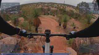
Popular Bindoon Mountain Biking Trails
• 85 ★ 4.8 • 5,174 ft • 11 ft • 227 •
A fast, flowy descent trail with step downs, step ups, tabletops and rock gardens allowing riders to develop their skills.
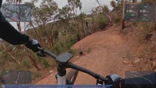
• 75 ★ 3.4 • 2,073 ft • 143 ft • 169 •
This flowing climb takes riders to the top of the dual slalom before winding its way through open bushland and rocky outcrops, offering a shorter route to the trail head.
• 80 ★ 4.0 • 646 ft • 0 ft • 155 •
Race your mates through fast, alternating berms into supercross style jump straight with rollers and on - off features
• 65 ★ 4.2 • 3 miles • 491 ft • 100 •
This dual use trail encircles the park, providing access to all of Bindoon Mountain Bike Park's trails and Trail Head, and views over the town, orchards and surrounding hills. Cyclists must ride in a clockwise direction, while walkers...
Photos of Bindoon Mountain Bike
Videos of Bindoon Mountain Bike

trail: Black Sheep
3:07 |
44 |
Jan 3, 2025
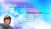
trail: Chinkabee Trail
0:35 |
37 |
Jan 3, 2025
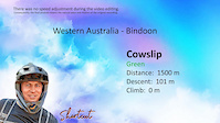
trail: Cowslip
3:08 |
26 |
Jan 3, 2025

trail: Flock Yes
3:22 |
31 |
Jan 3, 2025

trail: Ten 80
3:45 |
45 |
Jan 3, 2025
trail: Flock Yes
4:11 |
43 |
Apr 20, 2026 , Bindoon
trail: Ten 80
4:55 |
22 |
Apr 20, 2026 , Bindoon
trail: Chinkabee Trail
0:35 |
67 |
Apr 15, 2026 , Bindoon
Recent Trail Reports
| status | trail | date | condition | info | user |
|---|---|---|---|---|---|
| Black Sheep | May 23, 2026 @ 8:57am (Australia/Perth) May 22, 2026 | Ideal | shortcut-western-australia | ||
| Daniel's Downhill Duo | May 23, 2026 @ 8:57am (Australia/Perth) May 22, 2026 | Ideal | shortcut-western-australia | ||
| Ewe-Choose | May 23, 2026 @ 8:57am (Australia/Perth) May 22, 2026 | Ideal | shortcut-western-australia | ||
| "Shuttle Road" | May 23, 2026 @ 8:57am (Australia/Perth) May 22, 2026 | Ideal | shortcut-western-australia | ||
| Chinkabee Trail | May 23, 2026 @ 8:57am (Australia/Perth) May 22, 2026 | Ideal | shortcut-western-australia | ||
| Ten 80 | May 23, 2026 @ 8:57am (Australia/Perth) May 22, 2026 | Ideal | shortcut-western-australia | ||
| Ewe-Turn connector | May 23, 2026 @ 8:57am (Australia/Perth) May 22, 2026 | Ideal | shortcut-western-australia | ||
| Cowslip | May 23, 2026 @ 8:57am (Australia/Perth) May 22, 2026 | Ideal | shortcut-western-australia | ||
| Exit to Chinkabee | May 23, 2026 @ 8:57am (Australia/Perth) May 22, 2026 | Ideal | shortcut-western-australia | ||
| Flock Yes | May 23, 2026 @ 8:57am (Australia/Perth) May 22, 2026 | Ideal | shortcut-western-australia |
Activity Feed
| username | action | type | title | date |
|---|---|---|---|---|
| WillieJacobsz | add | region | activity #96035842 | Jun 1, 2026 @ 12:54pm Jun 1, 2026 |
Recent Comments
| username | type | title | comment | date |
|---|---|---|---|---|
| trail | Bit rutted out | May 4, 2026 @ 12:21am May 4, 2026 | ||
| trail | Cool Run for a green trail | May 4, 2026 @ 12:20am May 4, 2026 | ||
| trail | Best blue trail in WA 5/5 | Apr 20, 2024 @ 12:24am Apr 20, 2024 |
Activity Type Stats
| activitytype | trails | distance | descent | descent distance | total vertical | rating | global rank | state rank | photos | reports | routes | ridelogs |
|---|---|---|---|---|---|---|---|---|---|---|---|---|
| Mountain Bike | 12 | 11 miles | 2,638 ft | 6 miles | 358 ft | #11,258 | #314 | 15 | 40 | 373 | ||
| E-Bike | 12 | 11 miles | 2,638 ft | 6 miles | 358 ft | #6,274 | #261 | 40 | 209 | |||
| Gravel Bike | 2 | 3 miles | 453 ft | 1 mile | 341 ft | #784 | #127 | 2 | ||||
| Adaptive Bike | 3 | 3 miles | 453 ft | 1 mile | 354 ft | #736 | #197 | 1 | ||||
| Winter Fat Bike | 1 | 2,913 ft | 184 ft | #475 | #103 | |||||||
| Hike | 4 | 6 miles | 942 ft | 3 miles | 354 ft | #13,334 | #404 | 37 | 6 | |||
| Trail Running | 3 | 3 miles | 453 ft | 1 mile | 354 ft | #14,157 | #419 | 37 | 14 |
Frequently Asked Questions About Bindoon
▼
What are the best places to ride in Bindoon?
Bindoon has 1 areas to explore for mountain biking. The top rated areas are:
▼
What are the highest rated mountain biking trails in Bindoon?
The highest rated mountain biking trails in Bindoon are:
- Flock Yes (4.3/5)
- Black Sheep (4.2/5)
- Ten 80 (4.2/5)
- Cowslip (4.1/5)
- Doon Hill (4.1/5)
▼
Where can I park to ride in Bindoon?
There are 1 parking locations listed in Bindoon. The most popular parking spots are:
▼
What is the longest trail in Bindoon?
The longest trail in Bindoon is Chinkabee Trail at 3.2 miles. View all trails sorted by distance.
- By WillieJacobsz
 Trailforks SBP SWW & contributors
 - Admins: MTBWA
- #74227 - 100 views
- bindoon activity log | embed map of Bindoon mountain bike trails | bindoon mountain biking points of interest
Downloading of trail gps tracks in kml & gpx formats is enabled for Bindoon.
You must login to download files.