close
-
Layers w
- Map Content
- More Layers
- Pro
- Pro
- Pro
- Pro
- Pro
- Pro
- Pro
- Pro
-
Upgrade to

3D
Trail Conditions
- Unknown
- Snow Groomed
- Snow Packed
- Snow Covered
- Snow Cover Partial
- Freeze/thaw Cycle
- Icy
- Prevalent Mud
- Wet
- Variable
- Ideal
- Dry
- Very Dry
Trail Flow (Ridden Direction)
Trailforks scans users ridelogs to determine the most popular direction each trail is ridden. A good flowing trail network will have most trails flowing in a single direction according to their intension.
The colour categories are based on what percentage of riders are riding a trail in its intended direction.
The colour categories are based on what percentage of riders are riding a trail in its intended direction.
- > 96%
- > 90%
- > 80%
- > 70%
- > 50%
- < 50%
- bi-directional trail
- no data
Trail Last Ridden
Trailforks scans ridelogs to determine the last time a trail was ridden.
- < 2 days
- < 1 week
- < 2 weeks
- < 1 month
- < 6 months
- > 6 months
Trail Ridden Direction
The intended direction a trail should be ridden.
- Downhill Only
- Downhill Primary
- Both Directions
- Uphill Primary
- Uphill Only
- One Direction
Contribute Details
Colors indicate trail is missing specified detail.
- Description
- Photos
- Description & Photos
- Videos
Trail Popularity ?
Trailforks scans ridelogs to determine which trails are ridden the most in the last 9 months.
Trails are compared with nearby trails in the same city region with a possible 25 colour shades.
Think of this as a heatmap, more rides = more kinetic energy = warmer colors.
- most popular
- popular
- less popular
- not popular
ATV/ORV/OHV Filter
Max Vehicle Width
inches
US Cell Coverage
Legend

Radar Time
x
Activity Recordings
Trailforks users anonymized public ridelogs from the past 6 months.
- mountain biking recent
- mountain biking (>6 month)
- hiking (1 year)
- moto (1 year)
Activity Recordings
Trailforks users anonymized public skilogs from the past 12 months.
- Downhill Ski
- Backcountry Ski
- Nordic Ski
- Snowmobile
Winter Trails
Warning
A routing network for winter maps does not exist. Selecting trails using the winter trails layer has been disabled.
x
Missing Trails
Most Popular
Least Popular
Trails are colored based on popularity. The more popular a trail is, the more red. Less popular trails trend towards green.
Jump Magnitude Heatmap
Heatmap of where riders jump on trails. Zoom in to see individual jumps, click circles to view jump details.
Trails Deemphasized
Trails are shown in grey.
Only show trails with NO bikes.
Save the current map location and zoom level as your default home location whenever this page is loaded.
SaveThe Torn Shirt loop is a little over 5 miles long and is considered an advanced ride. The Murray Lake Trail is between 7 and 9 miles long depending on which loops you ride and is considered a more moderate trail.
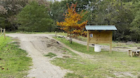
 google parking directions
 Access Info:
How to get there from Ann Arbor:
Take US-23 north for 18 miles. Exit at Silver Lake Rd. (Exit 55). Turn left. Take the next left onto Whitmore lake Rd. Take the next right onto Winan’s Lake Rd. This T’s into Hamburg Rd. Take a right. After a short distance take another right to stay on Hamburg Rd. After about 2 miles, turn left onto Bauer Rd (large dirt rd). Turn left at the second intersection, which is Bishop Lake Rd. Take this for one mile and the Bishop Lake Parking lot is on your left. Drive time from Ann Arbor is 30 min.
-or-
US 23 north to Exit 54B. West to Chilson Road (app 5 Miles), north on Chilson 3 * Miles to Park HQ, then east on Bishop Lake Road to the trail head.
How to get there from Flint:
Take US-23 south to I-96 west, exit almost immediately at Spencer Rd. Turn Right on Spencer Rd (West), cross Grand River, and continue west (now called Brighton Rd.) until you get to a strange X-shaped intersection, Chilson Rd. Turn left, go south about 1 mile, then turn left at Bishop lake Road. Continue east about 1 mile, passing the Bishop Lake beach, then turn right at the Bishop Lake parking lot entrance.
-or-
South on US 23 to I-96, west one exit to #147 then follow directions from Detroit.
How to get there from Detroit:
West on I-96 to Exit 147, through Brighton app. 6 miles to Chilson Road, south on Chilson to Park HQ, then east on Bishop Lake Road to the Trail Head.
How to get there from Lansing:
East on I-96 to Exit 137, south on D-19 to Coon Lake Road, East to Chilson Road, south to Park HQ, then east on Bishop Lake Road to the Trail Head.
Activities Click to view
- Mountain Bike
16 trails
- Horse
52 trails
- Hike
68 trails
- Trail Running
68 trails
Region Details
- 10
- 5
- 1
Region Status
Caution as of May 13, 2024Stats
- Avg Trail Rating
- Trails (view details)
- 69
- Trails Mountain Bike
- 16
- Trails Horse
- 52
- Trails Hike
- 68
- Trails Trail Running
- 68
- Trails Snowshoe
- 48
- Trails Backcountry Ski
- 47
- Trails Nordic Ski
- 1
- Total Distance
- 99 miles
- Total Descent
- 3,869 ft
- Total Vertical
- 207 ft
- Highest Trailhead
- 1,078 ft
- Reports
- 252
- Photos
- 45
- Ridden Counter
- 5,954
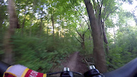
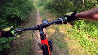
Popular Brighton Recreation Area Mountain Biking Trails
Brighton Recreation Area Mountain Bike Routes
| title | rating | distance |
|---|---|---|
| Brighton Hard Loop Snack Pack | 17 miles | |
| 18 mile Brighton Recreation Area Ride | popular ridelog | 18 miles |
| 21 mile Brighton Recreation Area Ride | popular ridelog | 21 miles |
| 9 mile Brighton Recreation Area Ride | popular ridelog | 9 miles |
| 7 mile Brighton Recreation Area All-Mountain Ride | popular ridelog | 7 miles |
| 16 mile Brighton Recreation Area Ride | popular ridelog | 16 miles |
| 12 mile Brighton Recreation Area Ride | popular ridelog | 12 miles |
| 25 mile Brighton Recreation Area All-Mountain Ride | popular ridelog | 25 miles |
| 22 mile Brighton Recreation Area Ride | popular ridelog | 22 miles |
| 9 mile Brighton Recreation Area Ride | popular ridelog | 9 miles |
Photos of Brighton Recreation Area Mountain Bike
trail: Torn Shirt Trail
0 |
May 4, 2024 @ 6:00pm
May 4, 2024
trail: Lost Loop
9 |
Oct 4, 2023 @ 5:28pm
Oct 4, 2023
trail: Lost Loop
9 |
Oct 4, 2023 @ 5:28pm
Oct 4, 2023
trail: Murray Lake Trail
271 |
Jun 8, 2017 @ 4:57pm
Jun 8, 2017Videos of Brighton Recreation Area Mountain Bike

|
Oct 24, 2023
|
Oct 24, 2023
trail: Murray Lake Trail
1:35 |
360 |
Sep 5, 2016
5:49 |
207 |
Apr 13, 2022

trail: Ralph's Ride
13:45 |
199 |
Aug 2, 2021 , Brighton
trail: Found Loop
13:45 |
177 |
Aug 2, 2021 , Brighton

trail: Lost Loop
13:45 |
165 |
Aug 2, 2021 , Brighton

trail: Murray Lake Trail
13:45 |
298 |
Aug 2, 2021 , Brighton
Recent Trail Reports
| status | trail | date | condition | info | user |
|---|---|---|---|---|---|
| Appleton Loop | May 13, 2024 @ 9:47am May 13, 2024 | Ideal | cMhvw9 | ||
| Torn Shirt Trail | May 12, 2024 @ 6:07am May 12, 2024 | Wet | LukeFuentesAJ | ||
| Appleton Access | Apr 15, 2024 @ 12:05pm Apr 15, 2024 | Ideal | MDRoseberry | ||
| Found Loop | Apr 15, 2024 @ 12:05pm Apr 15, 2024 | Ideal | MDRoseberry | ||
| Ralph's Ride | Apr 15, 2024 @ 12:05pm Apr 15, 2024 | Ideal | MDRoseberry | ||
| Murray Lake Trail | Apr 15, 2024 @ 12:05pm Apr 15, 2024 | Ideal | MDRoseberry | ||
| Murray Lake Connector | Apr 15, 2024 @ 12:05pm Apr 15, 2024 | Ideal | MDRoseberry | ||
| Appleton North | Mar 28, 2024 @ 11:18am Mar 28, 2024 | Variable | neubreed | ||
| Appleton Extension | Mar 28, 2024 @ 11:18am Mar 28, 2024 | Ideal | neubreed | ||
| Lost Loop | Dec 15, 2023 @ 9:07am Dec 15, 2023 | Variable | platter15 |
Activity Feed
| username | action | type | title | date |
|---|---|---|---|---|
| cMhvw9 | add | report | activity #52649941 | May 15, 2024 @ 2:12pm 2 days |
| LukeFuentesAJ | add | report | activity #52483840 | May 12, 2024 @ 9:11am May 12, 2024 |
| BrianPay26 | add | photo | activity #52100868 | May 4, 2024 @ 6:00pm May 4, 2024 |
| k5beason | wishlist | trail | activity #51931743 | May 1, 2024 @ 6:20am May 1, 2024 |
| seanwellwood | wishlist | region | activity #51646265 | Apr 24, 2024 @ 6:06pm Apr 24, 2024 |
Recent Comments
| username | type | title | comment | date |
|---|---|---|---|---|
| trail | No jumps, lots of roots, and if that is your... | Jul 24, 2023 @ 5:21pm Jul 24, 2023 | ||
| trail | I would definitely not classify as a Black.... | Sep 19, 2022 @ 11:38am Sep 19, 2022 | ||
| trail | Not sure why the elevation profile for this... | Aug 31, 2020 @ 8:04pm Aug 31, 2020 | ||
| trail | Great trail some down hill tech and great... | Jul 19, 2020 @ 6:28pm Jul 19, 2020 | ||
| trail | Tons of loose rock on hills, covered in stuff... | Jul 28, 2019 @ 4:32pm Jul 28, 2019 |
Nearby Areas
| name | distance | ||||
|---|---|---|---|---|---|
| Huron Meadows Metropark | 3.2 km | ||||
| Island Lake Recreation Area | 12 | 4 | 6.2 km | ||
| Independence Lake County Park | 6.7 km | ||||
| Pinckney Recreation Area | 2 | 2 | 9.2 km | ||
| Kensington Metropark | 3 | 10.1 km |
Local Badges
-

Completionist0 awarded
Bike & Skill Parks
| name | type | city | rating |
|---|---|---|---|
| Brighton Recreation Area Skillpark | skill park | Brighton |
Local Mountain Biking Directory
-
Motor City Bicycle (Brighton)
![Motor City Bicycle (Brighton)]()
-
D&d BicyclesBike Shop
-
Ride BoutiqueBike Shop
-
The Shop Bikes And BoardsBike Shop
Activity Type Stats
| activitytype | trails | distance | descent | descent distance | total vertical | rating | global rank | state rank | photos | reports | routes | ridelogs |
|---|---|---|---|---|---|---|---|---|---|---|---|---|
| Mountain Bike | 16 | 23 miles | 1,877 ft | 8 miles | 98 ft | #1,087 | #573 | 45 | 252 | 1 | 6,313 | |
| Horse | 52 | 72 miles | 1,624 ft | 6 miles | 187 ft | #1,291 | 45 | 47 | ||||
| Hike | 68 | 98 miles | 3,770 ft | 15 miles | 207 ft | #833 | #519 | 250 | 177 | |||
| Trail Running | 68 | 98 miles | 3,770 ft | 15 miles | 207 ft | #835 | #516 | 250 | 61 | |||
| Snowshoe | 48 | 71 miles | 1,588 ft | 5 miles | 167 ft | |||||||
| Backcountry Ski | 47 | 69 miles | 1,499 ft | 5 miles | 167 ft | |||||||
| Nordic Ski | 1 | 1 mile | 89 ft | 3,366 ft | 43 ft |
- By brenthillier
 NSMBA TRAILFORKS & contributors
 - Admins: PotoMBA, PotoMBA
- #4027 - 15,771 views
- brighton recreation area activity log | embed map of Brighton Recreation Area mountain bike trails | brighton recreation area mountain biking points of interest
Downloading of trail gps tracks in kml & gpx formats is enabled for Brighton Recreation Area.
You must login to download files.