close
-
Layers w
- Weather Layers
- Pro
- Pro
- Pro
- Pro
- Pro
- Pro
- More Layers
- Pro
- Pro
- Pro
- Pro
-
Upgrade to

3D
Trail Conditions
- Unknown
- Snow Groomed
- Snow Packed
- Snow Covered
- Snow Cover Partial
- Freeze/thaw Cycle
- Icy
- Prevalent Mud
- Wet
- Variable
- Ideal
- Dry
- Very Dry
Trail Flow (Ridden Direction)
Trailforks scans users ridelogs to determine the most popular direction each trail is ridden. A good flowing trail network will have most trails flowing in a single direction according to their intension.
The colour categories are based on what percentage of riders are riding a trail in its intended direction.
The colour categories are based on what percentage of riders are riding a trail in its intended direction.
- > 96%
- > 90%
- > 80%
- > 70%
- > 50%
- < 50%
- bi-directional trail
- no data
Trail Last Ridden
Trailforks scans ridelogs to determine the last time a trail was ridden.
- < 2 days
- < 1 week
- < 2 weeks
- < 1 month
- < 6 months
- > 6 months
Trail Ridden Direction
The intended direction a trail should be ridden.
- Downhill Only
- Downhill Primary
- Both Directions
- Uphill Primary
- Uphill Only
- One Direction
Contribute Details
Colors indicate trail is missing specified detail.
- Description
- Photos
- Description & Photos
- Videos
Trail Popularity ?
Trailforks scans ridelogs to determine which trails are ridden the most in the last 9 months.
Trails are compared with nearby trails in the same city region with a possible 25 colour shades.
Think of this as a heatmap, more rides = more kinetic energy = warmer colors.
- most popular
- popular
- less popular
- not popular
ATV/ORV/OHV Filter
Max Vehicle Width
inches
US Cell Coverage
Legend

Radar Time
Activity Recordings
Trailforks uses anonymized public activity data.
?
Activity Recordings
Trailforks uses anonymized public activity data.
?
Personal Heatmap
▶
Activity Types
all
/
none
▶
Options
2
Date range
month
–
Winter Trails
Warning
A routing network for winter maps does not exist. Selecting trails using the winter trails layer has been disabled.
Missing Trails
Most Popular
Least Popular
Trails are colored based on popularity. The more popular a trail is, the more red. Less popular trails trend towards green.
Jump Magnitude Heatmap
Heatmap of where riders jump on trails. Zoom in to see individual jumps, click circles to view jump details.
BC Backroad Status
![map legend]()
Service Road Atlas is a free to use, community-driven service for viewing and creating reports on the numerous back-country service roads around B.C. and Alberta.

Slope Aspect
Direction the slope faces
Trails Deemphasized
Trails are shown in grey.
Only show trails with no bike usage.
Suggested Layers
Based on selected activity type
Save the current map location and zoom level as your default home location whenever this page is loaded.
Save
No description for Buckner has been added yet!
Login or register to submit one.
Activities Click to view
- Mountain Bike
26 trails
- Gravel Bike
0 trails
- Adaptive Bike
0 trails
- Hike
26 trails
- Trail Running
26 trails
Region Details
- 3
- 1
- 7
- 6
- 8
- 1
Region Status
Caution as of Nov 10, 2025Local Trail Association
Stats
- Avg Trail Rating
- Trails (view details)
- 26
- Trails Mountain Bike
- 26
- Trails E-Bike
- 1
- Trails Hike
- 26
- Trails Trail Running
- 26
- Total Distance
- 20 miles
- Total Descent
- 2,165 ft
- Total Vertical
- 183 ft
- Highest Trailhead
- 966 ft
- Reports
- 131
- Photos
- 31
- Ridden Counter
- 4,682
Sub Regions
-
William Landahl Park
- 3
- 4
- 6
Popular Buckner Mountain Biking Trails
• 100 ★ 4.6 • 2 miles • 190 ft • 381 •
Highly rated popular green difficulty singletrack. This mountain bike primary trail can be used both directions and has a moderate overall physical rating with a 190 ft green climb. On average it takes 19 minutes to complete this trail.
• 100 ★ 4.7 • 2,536 ft • 8 ft • 339 •
Fast flowing trail that parallels and works nicely as a loop with .
• 90 ★ 4.4 • 1 mile • 44 ft • 338 •
Mostly flowing but some rocks and roots to keep it real.
• 95 ★ 4.0 • 2,277 ft • 88 ft • 328 •
From the Argo parking lot take to "the hub" where Will's, Dave's, Family, , and Boulevard meet. Stop here to catch your breath or turn to your left and you will be on Dave's Maze. It starts by climbing up a few switchbacks. From here...
• 70 ★ 0.0 • 961 ft • 0 ft • 251 •
Popular blue difficulty singletrack. This mountain bike primary trail can be used both directions and has a moderate overall physical rating with a 0 ft blue climb. On average it takes 1 minutes to complete this trail.
• 80 ★ 3.5 • 1,988 ft • 32 ft • 237 •
Popular black diamond difficulty singletrack. This mountain bike primary trail can be used both directions. On average it takes 3 minutes to complete this trail.
• 85 ★ 0.0 • 699 ft • 50 ft • 222 •
Popular green difficulty singletrack. This mountain bike primary trail can be used both directions. On average it takes 1 minutes to complete this trail.
• 70 ★ 0.0 • 1,112 ft • 0 ft • 210 •
Popular blue difficulty singletrack. This mountain bike primary trail can be used both directions. On average it takes 2 minutes to complete this trail.
Buckner Mountain Bike Routes
8 miles • 541 ft • 4 •
Start out with some good tech challenge of rocks mixed with some short bursts of climbs. Once you get to...
21 miles • 1,489 ft • 21 •
• 13 miles • 1,023 ft • 14 •
• 4 miles • 179 ft • 5 •
• 8 miles • 502 ft • 10 •
• 6 miles • 455 ft • 3 •
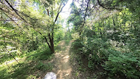
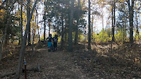
Photos of Buckner Mountain Bike
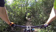
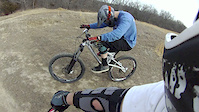
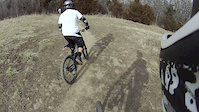
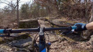
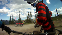
Videos of Buckner Mountain Bike
trail: ISH
0:04 |
105 |
Jul 5, 2023
trail: ISH
0:28 |
356 |
Jan 16, 2020
trail: Landahl Park Trail
0:13 |
211 |
Sep 13, 2015
trail: ISH
0:54 |
524 |
Feb 4, 2012
trail: ISH
0:47 |
487 |
Feb 4, 2012

trail: Will's Wanderer
16:44 |
90 |
Mar 28, 2025 , Buckner
trail: Tasty Goodness
16:44 |
152 |
Mar 28, 2025 , Buckner
trail: Boulevard
2:21 |
189 |
Aug 30, 2011
Recent Trail Reports
| status | trail | date | condition | info | user |
|---|---|---|---|---|---|
| Landahl Park Trail | Nov 10, 2025 @ 4:25pm (America/Chicago) Nov 10, 2025 | Unknown | magambi | ||
| Family Bypass | Jul 4, 2025 @ 10:02am Jul 4, 2025 | Dry | preston617 | ||
| Scout Camp (South) | Jun 10, 2025 @ 4:38pm Jun 10, 2025 | Unknown | ChunkyGoose | ||
| ISH | May 14, 2025 @ 7:02am May 14, 2025 | Dry | preston617 | ||
| Family Trail | Apr 17, 2024 @ 11:44am Apr 17, 2024 | Ideal | Cessig466 | ||
| Tasty Goodness | Mar 18, 2024 @ 2:00pm Mar 18, 2024 | Ideal | craigpaul2000 | ||
| Will's Wanderer | Mar 18, 2024 @ 2:00pm Mar 18, 2024 | Ideal | craigpaul2000 | ||
| Barrel Hub Connector | Mar 18, 2024 @ 2:00pm Mar 18, 2024 | Ideal | craigpaul2000 | ||
| Barrel Hub Connector 2 | Mar 18, 2024 @ 2:00pm Mar 18, 2024 | Ideal | craigpaul2000 | ||
| Rim Job | Mar 18, 2024 @ 2:00pm Mar 18, 2024 | Ideal | craigpaul2000 |
Activity Feed
| username | action | type | title | date |
|---|---|---|---|---|
| gnarlflow | ridden | trail | activity #91929397 | Apr 4, 2026 @ 1:47pm Apr 4, 2026 |
| rootrage | ridden | trail | activity #91920367 and 1 more | Apr 4, 2026 @ 12:02pm Apr 4, 2026 |
| endurosavage | ridden | trail | activity #91843119 and 1 more | Apr 3, 2026 @ 12:48pm Apr 3, 2026 |
| ridgerider68 | ridden | trail | activity #91682579 and 1 more | Mar 31, 2026 @ 6:02pm Mar 31, 2026 |
| zachbrownkc | wishlist | trail | activity #91490544 | Mar 28, 2026 @ 7:39pm Mar 28, 2026 |
Recent Comments
| username | type | title | comment | date |
|---|---|---|---|---|
| trail | it is very over grown at the end | Nov 7, 2025 @ 5:32pm Nov 7, 2025 | ||
| trail | Good trail, much easier than trail 11. But,... | Aug 23, 2025 @ 3:37pm Aug 23, 2025 | ||
| trail | Very strenuous with many repeated steep, rocky... | Aug 23, 2025 @ 3:36pm Aug 23, 2025 | ||
| trail | Connector crosses creek so if water is high... | Aug 23, 2025 @ 3:33pm Aug 23, 2025 | ||
| trail | Steepish rocky trail. Fun to go down, hard... | Aug 23, 2025 @ 3:32pm Aug 23, 2025 |
Local Badges
-

Epic Ride Climb 2k1 awarded -

Climbing 10k Badge10 awarded -

Climbing 100k Badge0 awarded -

Epic Ride Descent 2k1 awarded -

Descent 10k Badge10 awarded -

Descent 100k Badge0 awarded
Activity Type Stats
| activitytype | trails | distance | descent | descent distance | total vertical | rating | global rank | state rank | photos | reports | routes | ridelogs |
|---|---|---|---|---|---|---|---|---|---|---|---|---|
| Mountain Bike | 26 | 20 miles | 2,165 ft | 8 miles | 184 ft | #3,673 | #1,245 | 30 | 131 | 2 | 3,429 | |
| E-Bike | 1 | 85 | 1 | 231 | ||||||||
| Hike | 26 | 20 miles | 2,165 ft | 8 miles | 184 ft | #8,289 | #2,918 | 131 | 39 | |||
| Trail Running | 26 | 20 miles | 2,165 ft | 8 miles | 184 ft | #7,759 | #2,580 | 131 | 19 |
Frequently Asked Questions About Buckner
▼
What are the best places to ride in Buckner?
Buckner has 1 areas to explore for mountain biking. The top rated areas are:
▼
What are the highest rated mountain biking trails in Buckner?
The highest rated mountain biking trails in Buckner are:
- ISH (4.4/5)
- Will's Wanderer (4.3/5)
- Swedish Erotica (4.2/5)
- Scott's Gunbarrel (4.2/5)
- Barrel Hub Connector 2 (4.1/5)
▼
What is the best time of the year to ride in Buckner?
Based on ride log data, the most popular months to ride in Buckner are:
- July (78 activities)
- September (77 activities)
- October (58 activities)
▼
Where can I park to ride in Buckner?
There are 1 parking locations listed in Buckner. The most popular parking spots are:
- By brenthillier
 NSMBA TRAILFORKS & contributors
 - Admins: UTC Central, UTC South, UTC Master
- #18353 - 2,210 views
- buckner activity log | embed map of Buckner mountain bike trails | buckner mountain biking points of interest
Downloading of trail gps tracks in kml & gpx formats is enabled for Buckner.
You must login to download files.