close
-
Layers w
- Weather Layers
- Pro
- Pro
- Pro
- Pro
- Pro
- Pro
- More Layers
- Pro
- Pro
- Pro
- Pro
-
Upgrade to

3D
Trail Conditions
- Unknown
- Snow Groomed
- Snow Packed
- Snow Covered
- Snow Cover Partial
- Freeze/thaw Cycle
- Icy
- Prevalent Mud
- Wet
- Variable
- Ideal
- Dry
- Very Dry
Trail Flow (Ridden Direction)
Trailforks scans users ridelogs to determine the most popular direction each trail is ridden. A good flowing trail network will have most trails flowing in a single direction according to their intension.
The colour categories are based on what percentage of riders are riding a trail in its intended direction.
The colour categories are based on what percentage of riders are riding a trail in its intended direction.
- > 96%
- > 90%
- > 80%
- > 70%
- > 50%
- < 50%
- bi-directional trail
- no data
Trail Last Ridden
Trailforks scans ridelogs to determine the last time a trail was ridden.
- < 2 days
- < 1 week
- < 2 weeks
- < 1 month
- < 6 months
- > 6 months
Trail Ridden Direction
The intended direction a trail should be ridden.
- Downhill Only
- Downhill Primary
- Both Directions
- Uphill Primary
- Uphill Only
- One Direction
Contribute Details
Colors indicate trail is missing specified detail.
- Description
- Photos
- Description & Photos
- Videos
Trail Popularity ?
Trailforks scans ridelogs to determine which trails are ridden the most in the last 9 months.
Trails are compared with nearby trails in the same city region with a possible 25 colour shades.
Think of this as a heatmap, more rides = more kinetic energy = warmer colors.
- most popular
- popular
- less popular
- not popular
ATV/ORV/OHV Filter
Max Vehicle Width
inches
US Cell Coverage
Legend

Radar Time
Activity Recordings
Trailforks uses anonymized public activity data.
?
Activity Recordings
Trailforks uses anonymized public activity data.
?
Personal Heatmap
▶
Activity Types
all
/
none
▶
Options
2
Date range
month
–
Winter Trails
Warning
A routing network for winter maps does not exist. Selecting trails using the winter trails layer has been disabled.
Missing Trails
Most Popular
Least Popular
Trails are colored based on popularity. The more popular a trail is, the more red. Less popular trails trend towards green.
Jump Magnitude Heatmap
Heatmap of where riders jump on trails. Zoom in to see individual jumps, click circles to view jump details.
BC Backroad Status
![map legend]()
Service Road Atlas is a free to use, community-driven service for viewing and creating reports on the numerous back-country service roads around B.C. and Alberta.

Slope Aspect
Direction the slope faces
Trails Deemphasized
Trails are shown in grey.
Only show trails with no bike usage.
Suggested Layers
Based on selected activity type
Save the current map location and zoom level as your default home location whenever this page is loaded.
Save
No description for Canton has been added yet!
Login or register to submit one.
Activities Click to view
- Mountain Bike
19 trails
- Gravel Bike
0 trails
- Adaptive Bike
0 trails
- Hike
19 trails
- Trail Running
19 trails
Region Details
- 5
- 2
- 4
- 5
- 2
Region Status
Caution as of Jun 1, 2026Stats
- Avg Trail Rating
- Trails (view details)
- 18
- Trails Mountain Bike
- 19
- Trails Winter Fat Bike
- 1
- Trails Hike
- 19
- Trails Trail Running
- 19
- Total Distance
- 11 miles
- Total Descent
- 274 ft
- Total Vertical
- 37 ft
- Highest Trailhead
- 686 ft
- Reports
- 38
- Photos
- 25
- Ridden Counter
- 725
Sub Regions
-
Morton-Taylor Trails
- 3
- 4
- 2
Popular Canton Mountain Biking Trails
• 45 ★ 0.0 • 1 mile • 37 ft • 53 •
: This trail starts on the left (West) side of Morton-Taylor road just North of the main pedestrain bridge # 5. It starts out straight with a loop at the end and contains 9-10 optional log piles along the way that gives the rider a...
• 90 ★ 1.7 • 1,647 ft • 2 ft • 52 •
This section runs east and west between Lilley and Morton-Taylor roads connecting the East and West loops. To access it from the end of the you turn left onto Lilley road taking it to the gravel pathway making another left and heading...
• 75 ★ 0.0 • 3 miles • 18 ft • 51 •
Mostly gravel path that takes you along the Lower River Rouge and through Heritage Park where you can make loops and even hit some mountain bike trails. Trail connects to the paved I-275 Metro Path
• 95 ★ 0.0 • 2,147 ft • 15 ft • 47 •
Popular blue difficulty singletrack. This mountain bike primary trail can be used both directions. On average it takes 6 minutes to complete this trail.
• 65 ★ 0.0 • 2,016 ft • 27 ft • 44 •
This trail begins just across Morton-Taylor road near the entrance of the parking lot just beyond the gate. It follows along the ridgeline with scenic views of the river. After passing through the ITC power line area it continues behind...
• 70 ★ 0.0 • 3,540 ft • 31 ft • 42 •
This trail starts right off of the parking lot going north along the gravel path. Just after crossing the small foot bridge you can turn right onto the Buckshaver section or left going towards the Dragon's Tail and South Wetland...
• 85 ★ 0.0 • 808 ft • 7 ft • 42 •
Popular blue difficulty singletrack. This mountain bike primary trail can be used both directions. On average it takes minutes to complete this trail.
• 100 ★ 0.0 • 874 ft • 2 ft • 37 •
This section runs east and west between Lilley and Morton-Taylor roads connecting the East and West loops. To access it from the end of the you turn left onto Lilley road taking it to the gravel pathway making another left and heading...
Canton Mountain Bike Routes
4 miles • 46 ft • 10 • Point to Point •
These are easy fun cross country trails that are spread out where you need to take some gravel roads to...
5 miles • 24 ft • 0 • Loop •
Smooth and flat 5 mile loop contained within two subdivisions. Great for suburbanites to get in multiple...
Photos of Canton Mountain Bike
Videos of Canton Mountain Bike
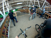
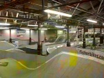
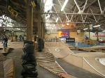
trail: Pump Track
0:54 |
213 |
Apr 18, 2012
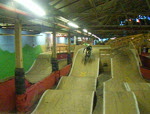
trail: Pump Track
0:18 |
183 |
Jan 17, 2011

trail: Pump Track
0:39 |
375 |
Jan 1, 2011
youtuber
![Epic Mountain Biking Adventure: Morton-Taylor]()

5:38 |
210 |
May 7, 2023
trail: Pump Track
0:16 |
167 |
Nov 16, 2009

trail: Pump Track
0:33 |
386 |
Oct 20, 2009
trail: Pump Track
0:09 |
98 |
Mar 12, 2009
Recent Trail Reports
| status | trail | date | condition | info | user |
|---|---|---|---|---|---|
| Morton Taylor Trailhead Access | Jun 1, 2026 @ 8:34pm (America/Detroit) Jun 1, 2026 | Ideal | ftgeib | ||
| Crooked Vulture | Jun 1, 2026 @ 8:34pm (America/Detroit) Jun 1, 2026 | Prevalent Mud | ftgeib | ||
| Crooked Vulture | Jun 1, 2026 @ 8:34pm (America/Detroit) Jun 1, 2026 | Variable | ftgeib | ||
| Morton-Taylor Loop | Jun 1, 2026 @ 8:34pm (America/Detroit) Jun 1, 2026 | Ideal | ftgeib | ||
| Buckshaver Trail | Jun 1, 2026 @ 8:34pm (America/Detroit) Jun 1, 2026 | Variable | ftgeib | ||
| South Loop Alternate Connector | Jun 1, 2026 @ 8:34pm (America/Detroit) Jun 1, 2026 | Variable | ftgeib | ||
| West Loop | May 27, 2023 @ 11:38am May 27, 2023 | Wet | Bmw199500 | ||
| Lower Rouge Trail | Jun 5, 2022 @ 5:56am Jun 5, 2022 | Variable | sherpaboy MCMBA | ||
| Lower Rogue Alt | Sep 7, 2020 @ 1:53pm Sep 7, 2020 | Ideal | Billyboy413 | ||
| East Loop | Jul 15, 2020 @ 7:42pm Jul 15, 2020 | Variable | Wulfbrick |
Activity Feed
| username | action | type | title | date |
|---|---|---|---|---|
| ftgeib | ridden | skillpark | activity #96625896 | Jun 9, 2026 @ 1:15pm Jun 9, 2026 |
| ftgeib | add | skillpark | activity #96620293 | Jun 9, 2026 @ 11:41am Jun 9, 2026 |
| BrennynkB0w4v | ridden | trail | activity #96578496 and 1 more | Jun 8, 2026 @ 6:34pm Jun 8, 2026 |
| ftgeib | difficultyvote | trail | activity #96058416 | Jun 1, 2026 @ 7:36pm Jun 1, 2026 |
| ftgeib | add | report | activity #96058063 and 5 more | Jun 1, 2026 @ 7:27pm Jun 1, 2026 |
Recent Comments
| username | type | title | comment | date |
|---|---|---|---|---|
| trail | yeah, that is hat I ran in to. Do they dry out... | Apr 25, 2023 @ 8:48am Apr 25, 2023 | ||
| trail | yeah, that is hat I ran in to. Do they dry out... | Apr 25, 2023 @ 8:47am Apr 25, 2023 | ||
| trail | Nice pump track | Jul 12, 2020 @ 1:55pm Jul 12, 2020 | ||
| trail | Trail is pretty much under water and very muddy. | Apr 5, 2020 @ 4:28pm Apr 5, 2020 | ||
| trail | This trail’s pretty much abandoned and under... | May 24, 2019 @ 5:47pm May 24, 2019 |
Local Badges
-

Epic Ride Climb 2k1 awarded -

Climbing 10k Badge2 awarded -

Climbing 100k Badge0 awarded -

Epic Ride Descent 2k1 awarded -

Descent 10k Badge2 awarded -

Descent 100k Badge0 awarded
Bike & Skill Parks
| name | type | city | rating |
|---|---|---|---|
| Morton-Taylor Pump Track | skill park | Canton |
Activity Type Stats
| activitytype | trails | distance | descent | descent distance | total vertical | rating | global rank | state rank | photos | reports | routes | ridelogs |
|---|---|---|---|---|---|---|---|---|---|---|---|---|
| Mountain Bike | 19 | 11 miles | 276 ft | 3 miles | 36 ft | #9,479 | #2,968 | 25 | 38 | 2 | 2,205 | |
| Winter Fat Bike | 1 | #7,655 | #2,409 | |||||||||
| Hike | 19 | 11 miles | 276 ft | 3 miles | 36 ft | #10,290 | #3,663 | 38 | 1 | 18 | ||
| Trail Running | 19 | 11 miles | 276 ft | 3 miles | 36 ft | #9,754 | #3,326 | 38 | 21 |
Frequently Asked Questions About Canton
▼
What are the best places to ride in Canton?
Canton has 1 areas to explore for mountain biking. The top rated areas are:
▼
What are the highest rated mountain biking trails in Canton?
The highest rated mountain biking trails in Canton are:
- Pump Track (3.6/5)
- Crooked Vulture (3.2/5)
- West Loop (0/5)
- East Loop (0/5)
- Buckshaver Trail (0/5)
▼
What is the best time of the year to ride in Canton?
Based on ride log data, the most popular months to ride in Canton are:
- August (23 activities)
- September (20 activities)
- July (16 activities)
▼
Where can I park to ride in Canton?
There are 1 parking locations listed in Canton. The most popular parking spots are:
- By markholloway
 Trailforks Map Team & contributors
 - Admins: PotoMBA, MCMBA
- #11578 - 3,514 views
- canton activity log | embed map of Canton mountain bike trails | canton mountain biking points of interest
Downloading of trail gps tracks in kml & gpx formats is enabled for Canton.
You must login to download files.