close
-
Layers w
- Weather Layers
- Pro
- Pro
- Pro
- Pro
- Pro
- Pro
- More Layers
- Pro
- Pro
- Pro
- Pro
-
Upgrade to

3D
Trail Conditions
- Unknown
- Snow Groomed
- Snow Packed
- Snow Covered
- Snow Cover Partial
- Freeze/thaw Cycle
- Icy
- Prevalent Mud
- Wet
- Variable
- Ideal
- Dry
- Very Dry
Trail Flow (Ridden Direction)
Trailforks scans users ridelogs to determine the most popular direction each trail is ridden. A good flowing trail network will have most trails flowing in a single direction according to their intension.
The colour categories are based on what percentage of riders are riding a trail in its intended direction.
The colour categories are based on what percentage of riders are riding a trail in its intended direction.
- > 96%
- > 90%
- > 80%
- > 70%
- > 50%
- < 50%
- bi-directional trail
- no data
Trail Last Ridden
Trailforks scans ridelogs to determine the last time a trail was ridden.
- < 2 days
- < 1 week
- < 2 weeks
- < 1 month
- < 6 months
- > 6 months
Trail Ridden Direction
The intended direction a trail should be ridden.
- Downhill Only
- Downhill Primary
- Both Directions
- Uphill Primary
- Uphill Only
- One Direction
Contribute Details
Colors indicate trail is missing specified detail.
- Description
- Photos
- Description & Photos
- Videos
Trail Popularity ?
Trailforks scans ridelogs to determine which trails are ridden the most in the last 9 months.
Trails are compared with nearby trails in the same city region with a possible 25 colour shades.
Think of this as a heatmap, more rides = more kinetic energy = warmer colors.
- most popular
- popular
- less popular
- not popular
ATV/ORV/OHV Filter
Max Vehicle Width
inches
US Cell Coverage
Legend

Radar Time
Activity Recordings
Trailforks uses anonymized public activity data.
?
Activity Recordings
Trailforks uses anonymized public activity data.
?
Personal Heatmap
▶
Activity Types
all
/
none
▶
Options
2
Date range
month
–
Winter Trails
Warning
A routing network for winter maps does not exist. Selecting trails using the winter trails layer has been disabled.
Missing Trails
Most Popular
Least Popular
Trails are colored based on popularity. The more popular a trail is, the more red. Less popular trails trend towards green.
Jump Magnitude Heatmap
Heatmap of where riders jump on trails. Zoom in to see individual jumps, click circles to view jump details.
BC Backroad Status
![map legend]()
Service Road Atlas is a free to use, community-driven service for viewing and creating reports on the numerous back-country service roads around B.C. and Alberta.

Slope Aspect
Direction the slope faces
Trails Deemphasized
Trails are shown in grey.
Only show trails with no bike usage.
Suggested Layers
Based on selected activity type
Save the current map location and zoom level as your default home location whenever this page is loaded.
Save
No description for Chiusaforte has been added yet!
Login or register to submit one.
This region uses the Uk/Euro style trail grading system.
Activities Click to view
- Mountain Bike
19 trails
- E-Bike
7 trails
- Adaptive Bike
0 trails
- Winter Fat Bike
0 trails
- Hike
19 trails
- Trail Running
19 trails
Region Details
- 8
- 1
- 2
- 1
- 3
Region Status
Open as of Jun 13, 2026Stats
- Avg Trail Rating
- Trails (view details)
- 19
- Trails Mountain Bike
- 19
- Trails E-Bike
- 7
- Trails Hike
- 19
- Trails Trail Running
- 19
- Total Distance
- 49 miles
- Total Descent
- 15,398 ft
- Total Vertical
- 6,136 ft
- Highest Trailhead
- 6,899 ft
- Reports
- 45
- Photos
- 89
- Ridden Counter
- 754
Sub Regions
-
Scluse
- 1
- 1
- 2
-
Sella Nevea
- 1
- 1
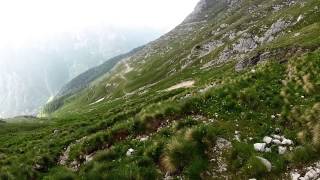
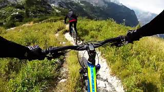
Popular Chiusaforte Mountain Biking Trails
• 100 ★ 0.0 • 22 miles • 538 ft • 201 •
A Pontebba salutiamo la Val Canale ed entriamo nel Canal del Ferro. Superate le ultime case di Pontebba, sulla destra si stacca la nuova pista ciclabile che con una brusca salita permette di raggiungere il sedime della vecchia ferrovia...
• 95 ★ 3.5 • 2 miles • 739 ft • 52 • • hike
Popular blue difficulty alpine singletrack. This hike primary trail can be used both directions and has a moderate overall physical rating with a 739 ft blue climb. Trail visibility is always easy to follow. On average it takes 53 minutes to complete this trail.
• 65 ★ 5.0 • 3 miles • 67 ft • 45 •
Moderately popular black difficulty singletrack. This mountain bike primary trail can be used downhill only. On average it takes 54 minutes to complete this trail.
• 80 ★ 4.3 • 2 miles • 168 ft • 37 •
Popular red difficulty singletrack. This mountain bike primary trail can be used downhill primary and has a moderate overall physical rating with a 168 ft blue climb. Trail visibility is sometimes hard to follow. On average it takes 27 minutes to complete this trail.
• 90 ★ 3.0 • 3,041 ft • 579 ft • 36 •
Popular red difficulty alpine singletrack. This mountain bike primary trail can be used downhill only and has a hard overall physical rating with a 579 ft black diamond climb. Trail visibility is always easy to follow. On average it takes 39 minutes to complete this trail.
• 15 ★ 5.0 • 3 miles • 79 ft • 22 •
Less popular red difficulty alpine singletrack. This mountain bike primary trail can be used downhill only and has a hard overall physical rating. Trail visibility is sometimes hard to follow. On average it takes 41 minutes to complete this trail.
• 30 ★ 0.0 • 4,682 ft • 0 ft • 5 •
Be careful when riding, some parts are demanding, some parts are not well maintained. Many switchbacks in the lower part. Take care of traffic in the end of the trail when arriving at the main road SS13.
Photos of Chiusaforte Mountain Bike
Videos of Chiusaforte Mountain Bike
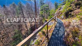
trail: ClapForat
11:15 |
57 |
Mar 8, 2026 , Chiusaforte
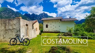
trail: CostaMolino DH
9:12 |
110 |
May 11, 2025 , Chiusaforte
7:09 |
91 |
Oct 24, 2024 , Chiusaforte
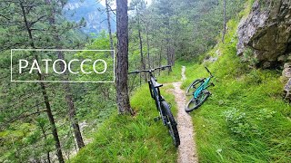
trail: Patocco DH
13:14 |
223 |
Jul 31, 2024 , Chiusaforte
4:56 |
153 |
Jul 26, 2024 , Chiusaforte
trail: Mulattiera del Poviz
7:01 |
310 |
Jan 9, 2024 , Chiusaforte

trail: Passo degli Scalini
4:56 |
188 |
Jan 9, 2024 , Chiusaforte
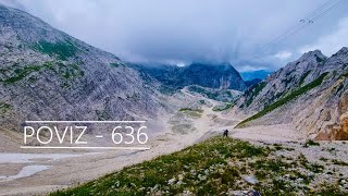
trail: Mulattiera del Poviz
29:26 |
417 |
Sep 7, 2023 , Chiusaforte
Recent Trail Reports
| status | trail | date | condition | info | user |
|---|---|---|---|---|---|
| Passo degli Scalini | Jun 13, 2026 @ 9:43am (Europe/Rome) Jun 13, 2026 | Ideal | Cesco92 | ||
| ChioutPupin DH | Mar 7, 2026 @ 6:07pm (Europe/Rome) Mar 7, 2026 | Dry | agvlt | ||
| ClapForat | Mar 7, 2026 @ 6:00pm (Europe/Rome) Mar 7, 2026 | Very Dry | agvlt | ||
| Sella Bila Pec - Sella di Grubia | Sep 1, 2025 @ 3:13am Sep 1, 2025 | Ideal | LjOc5z | ||
| Patocco DH | Jul 6, 2025 @ 8:59am Jul 6, 2025 | Dry | chehar1 | ||
| Mulattiera del Poviz | Jul 6, 2025 @ 8:58am Jul 6, 2025 | Dry | chehar1 | ||
| CostaMolino DH | May 11, 2025 @ 8:41am May 11, 2025 | Dry | agvlt | ||
| Salita al Sella Bieliga e Malga Berda | Oct 20, 2024 @ 10:29am Oct 20, 2024 | Variable | blitzkneisser | ||
| Gilberti - Prevala uphill | Jul 21, 2024 @ 4:25am Jul 21, 2024 | Ideal | umbimore | ||
| FVG1 Alpe Adria (tratto Pontebba - Venzone) | Aug 22, 2023 @ 11:57pm Aug 22, 2023 | Ideal | Marvillo66 |
Activity Feed
| username | action | type | title | date |
|---|---|---|---|---|
| Cesco92 | add | report | activity #96852317 | Jun 13, 2026 @ 12:43am Jun 13, 2026 |
| raffaelemtb | ridden | trail | activity #96729752 | Jun 11, 2026 @ 5:06am Jun 11, 2026 |
| Seba99 | wishlist | trail | activity #96607060 | Jun 9, 2026 @ 8:17am Jun 9, 2026 |
| EfR9Ey | ridden | trail | activity #95251746 | May 22, 2026 @ 10:13am May 22, 2026 |
| losdecline | ridden | trail | activity #95247670 | May 22, 2026 @ 9:15am May 22, 2026 |
Recent Comments
| username | type | title | comment | date |
|---|---|---|---|---|
| report | I upload video of trail ... | Nov 17, 2025 @ 1:50am Nov 17, 2025 | ||
| report | Thank you agvlt for your pictures, they are... | Nov 16, 2025 @ 10:02am Nov 16, 2025 | ||
| trail | Fast and flowy at the top, definitely blue... | Jun 1, 2025 @ 5:15am Jun 1, 2025 | ||
| trail | Trail rating should be blue, not red | Jun 19, 2023 @ 7:28am Jun 19, 2023 | ||
| trail | Ideale | Apr 19, 2023 @ 9:38am Apr 19, 2023 |
Local Badges
-

Epic Mountain Bike Climb 2k27 awarded -

Climbing 10k Badge1 awarded -

Mountain Biking 100k Badge0 awarded -

Epic Ride Descent 2k27 awarded -

Descent 10k Badge1 awarded -

Descent 100k Badge0 awarded
Activity Type Stats
| activitytype | trails | distance | descent | descent distance | total vertical | rating | global rank | state rank | photos | reports | routes | ridelogs |
|---|---|---|---|---|---|---|---|---|---|---|---|---|
| Mountain Bike | 19 | 49 miles | 15,397 ft | 28 miles | 6,135 ft | #3,900 | #234 | 89 | 45 | 375 | ||
| E-Bike | 7 | 29 miles | 4,948 ft | 18 miles | 6,102 ft | #666 | #75 | 26 | 28 | |||
| Hike | 19 | 49 miles | 15,397 ft | 28 miles | 6,135 ft | #4,273 | #173 | 45 | 380 | |||
| Trail Running | 19 | 49 miles | 15,397 ft | 28 miles | 6,135 ft | #3,807 | #158 | 45 | 22 |
Frequently Asked Questions About Chiusaforte
▼
What are the best places to ride in Chiusaforte?
Chiusaforte has 2 areas to explore for mountain biking. The top rated areas are:
▼
What are the highest rated mountain biking trails in Chiusaforte?
The highest rated mountain biking trails in Chiusaforte are:
- Mulattiera del Poviz (4.4/5)
- Patocco DH (4.1/5)
- Passo degli Scalini (4.1/5)
- ClapForat (4/5)
- Sella Bila Pec - Sella di Grubia (3.9/5)
▼
What is the best time of the year to ride in Chiusaforte?
Based on ride log data, the most popular months to ride in Chiusaforte are:
- July (4 activities)
- September (4 activities)
- October (1 activities)
▼
Where can I park to ride in Chiusaforte?
There are 1 parking locations listed in Chiusaforte. The most popular parking spots are:
Activities
Trails
Points of Interest
- By maxmisdaris
 MGNR & contributors
 - Admins: maxmisdaris
- #40720 - 1,410 views
- chiusaforte activity log | embed map of Chiusaforte mountain bike trails | chiusaforte mountain biking points of interest
Downloading of trail gps tracks in kml & gpx formats is enabled for Chiusaforte.
You must login to download files.