close
-
Layers w
- Weather Layers
- Pro
- Pro
- Pro
- Pro
- Pro
- Pro
- More Layers
- Pro
- Pro
- Pro
- Pro
-
Upgrade to

3D
Trail Conditions
- Unknown
- Snow Groomed
- Snow Packed
- Snow Covered
- Snow Cover Partial
- Freeze/thaw Cycle
- Icy
- Prevalent Mud
- Wet
- Variable
- Ideal
- Dry
- Very Dry
Trail Flow (Ridden Direction)
Trailforks scans users ridelogs to determine the most popular direction each trail is ridden. A good flowing trail network will have most trails flowing in a single direction according to their intension.
The colour categories are based on what percentage of riders are riding a trail in its intended direction.
The colour categories are based on what percentage of riders are riding a trail in its intended direction.
- > 96%
- > 90%
- > 80%
- > 70%
- > 50%
- < 50%
- bi-directional trail
- no data
Trail Last Ridden
Trailforks scans ridelogs to determine the last time a trail was ridden.
- < 2 days
- < 1 week
- < 2 weeks
- < 1 month
- < 6 months
- > 6 months
Trail Ridden Direction
The intended direction a trail should be ridden.
- Downhill Only
- Downhill Primary
- Both Directions
- Uphill Primary
- Uphill Only
- One Direction
Contribute Details
Colors indicate trail is missing specified detail.
- Description
- Photos
- Description & Photos
- Videos
Trail Popularity ?
Trailforks scans ridelogs to determine which trails are ridden the most in the last 9 months.
Trails are compared with nearby trails in the same city region with a possible 25 colour shades.
Think of this as a heatmap, more rides = more kinetic energy = warmer colors.
- most popular
- popular
- less popular
- not popular
ATV/ORV/OHV Filter
Max Vehicle Width
inches
US Cell Coverage
Legend

Radar Time
Activity Recordings
Trailforks uses anonymized public activity data.
?
Activity Recordings
Trailforks uses anonymized public activity data.
?
Personal Heatmap
▶
Activity Types
all
/
none
▶
Options
2
Date range
month
–
Winter Trails
Warning
A routing network for winter maps does not exist. Selecting trails using the winter trails layer has been disabled.
Missing Trails
Most Popular
Least Popular
Trails are colored based on popularity. The more popular a trail is, the more red. Less popular trails trend towards green.
Jump Magnitude Heatmap
Heatmap of where riders jump on trails. Zoom in to see individual jumps, click circles to view jump details.
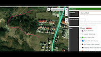
BC Backroad Status
![map legend]()
Service Road Atlas is a free to use, community-driven service for viewing and creating reports on the numerous back-country service roads around B.C. and Alberta.

Slope Aspect
Direction the slope faces
Trails Deemphasized
Trails are shown in grey.
Only show trails with no bike usage.
Suggested Layers
Based on selected activity type
Save the current map location and zoom level as your default home location whenever this page is loaded.
SaveThis region is Unsanctioned, Ride at your own Risk!
The main tourist destinations in the county are:
The city of Cluj-Napoca.
The Apuseni Mountains especially the caves Peștera Mare, Peștera Piatra Ponorului, Peștera Vârfurosu.
The historical centers of Turda, Dej, Gherla, Ciucea.
Cheile Turzii
Turda Salt Mine
The winter resort of Băișoara
The lakes of Beliș and Tarnița
The city of Cluj-Napoca.
The Apuseni Mountains especially the caves Peștera Mare, Peștera Piatra Ponorului, Peștera Vârfurosu.
The historical centers of Turda, Dej, Gherla, Ciucea.
Cheile Turzii
Turda Salt Mine
The winter resort of Băișoara
The lakes of Beliș and Tarnița
This region uses the Uk/Euro style trail grading system.
Region Details
- 37
- 9
- 18
- 37
- 1
Stats
- Avg Trail Rating
- Trails (view details)
- 119
- Trails Mountain Bike
- 134
- Trails E-Bike
- 98
- Trails Horse
- 4
- Trails Hike
- 85
- Trails Trail Running
- 86
- Trails Dirtbike/Moto
- 3
- Trails ATV/ORV/OHV
- 2
- Total Distance
- 108 miles
- Total Descent
- 27,564 ft
- Total Vertical
- 4,696 ft
- Highest Trailhead
- 5,656 ft
- Reports
- 403
- Photos
- 100
- Ridden Counter
- 2,887
Sub Regions
- Baisoara (27)
- Ciurila (6)
- Cluj-Napoca (68)
- Dealul Gârbāului (5)
- Făget Forest (30)
- Floresti (9)
- Măguri-Răcătău (2)
- Mărişel (6)
- Mihai Viteazu (1)
- Tureni (7)
- Viişoara (8)
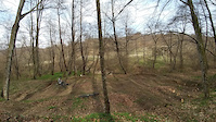
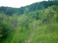
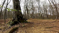
Popular Cluj Mountain Biking Trails
• 70 ★ 5.0 • 1,969 ft • 0 ft • 64 •
• 100 ★ 4.8 • 2 miles • 0 ft • 56 •
Popular green difficulty singletrack. This mountain bike primary trail can be used downhill only and has a easy overall physical rating. It features berm and bridge. Trail visibility is always easy to follow. On average it takes 10 minutes to complete this trail.
• 100 ★ 0.0 • 1,188 ft • 0 ft • 52 •
Popular green difficulty singletrack. This mountain bike primary trail can be used both directions and has a moderate overall physical rating with a 0 ft blue climb. It features roller coaster. Trail visibility is always easy to follow. On average it takes 1 minutes to complete this trail.
• 95 ★ 4.7 • 4,436 ft • 169 ft • 52 •
A usually very leafy trail that gets you up to or down from the . Awesome fun while descending, great training while climbing.
• 85 ★ 5.0 • 453 ft • 0 ft • 48 •
LiTTLE8 is a small pump track just enough to get your cardio beating :)
• 55 ★ 5.0 • 2,113 ft • 0 ft • 47 •
Cluj Mountain Bike Routes
27 miles • 3,188 ft • 9 • Loop •
A fairly hard and difficult route given that you have done some serious riding before. This route has...
17 miles • 2,490 ft • 0 • Loop •
Faget Marathon course 2015 edition, 26 km length
Photos of Cluj Mountain Bike
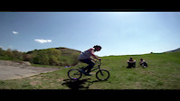
Videos of Cluj Mountain Bike
trail: codobelc | csiga biga
3:24 |
5 |
May 31, 2026
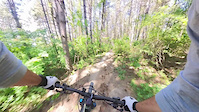
trail: Sunset trail
3:16 |
54 |
Feb 15, 2022
trail: 23 Line
0:39 |
160 |
May 3, 2020
trail: Spring
0:29 |
36 |
Mar 28, 2019
trail: Spring
0:58 |
44 |
Mar 28, 2019
trail: Spring
2:30 |
33 |
Dec 30, 2014
trail: Spring
4:18 |
88 |
Apr 10, 2014
trail: Spring
0:34 |
224 |
Apr 30, 2012
Recent Trail Reports
Activity Feed
| username | action | type | title | date |
|---|---|---|---|---|
| bancsi89 | add | photo | activity #96790062 | Jun 12, 2026 @ 1:43am Jun 12, 2026 |
| gyztms | add | report | activity #96140605 | Jun 3, 2026 @ 1:05am Jun 3, 2026 |
| gyztms | add | report | activity #96140604 | Jun 3, 2026 @ 1:05am Jun 3, 2026 |
| gyztms | add | report | activity #95961826 | May 31, 2026 @ 11:27am May 31, 2026 |
| gyztms | add | report | activity #95517644 and 2 more | May 25, 2026 @ 1:14pm May 25, 2026 |
Recent Comments
| username | type | title | comment | date |
|---|---|---|---|---|
| trail | cineva lo stricat deci nu mai e nimic acum | Oct 15, 2023 @ 11:11am Oct 15, 2023 | ||
| trail | e ciocaneala misto | Sep 30, 2023 @ 8:39am Sep 30, 2023 | ||
| trail | Beginning of the trails is still OK. A bridge... | Apr 27, 2023 @ 1:54am Apr 27, 2023 | ||
| report | Backcountry sking in august, yeah yeah, nice try. | Aug 1, 2022 @ 6:16am Aug 1, 2022 | ||
| trail | Could you put it on the map as a Black Diamond... | Nov 21, 2021 @ 12:26am Nov 21, 2021 |
Local Badges
-

Epic Ride 50k17 awarded -

Descent 100k Badge0 awarded -
Descent 100k Badge0 awarded -

Big Ride 30k73 awarded -
Epic Ride 50k170 awarded -
Big Ride 30k316 awarded
Bike & Skill Parks
| name | type | city | rating |
|---|---|---|---|
| Mosquito | skill park | Cluj-Napoca |
Local Trail Supporters
- Benedek Eno
- Iulian Vuscan
- Vuscan Iulian
- Balica Rares
- Pascu Cristi
- Istrate Mihai
- Jancso Gellert
- Chilea Razvan
![]()
- Cristi Pascu
Activity Type Stats
| activitytype | trails | distance | descent | descent distance | total vertical | rating | global rank | state rank | photos | reports | routes | ridelogs |
|---|---|---|---|---|---|---|---|---|---|---|---|---|
| Mountain Bike | 134 | 107 miles | 27,556 ft | 55 miles | 4,695 ft | 100 | 403 | 5 | 9,765 | |||
| E-Bike | 98 | 82 miles | 18,560 ft | 37 miles | 4,695 ft | 369 | 2 | 1,273 | ||||
| Horse | 4 | 14 miles | 3,018 ft | 4 miles | 3,688 ft | 5 | ||||||
| Hike | 85 | 91 miles | 16,575 ft | 39 miles | 4,695 ft | 1 | 386 | 788 | ||||
| Trail Running | 86 | 92 miles | 16,654 ft | 40 miles | 4,695 ft | 386 | 986 | |||||
| Dirtbike/Moto | 3 | 10 miles | 2,963 ft | 3 miles | 3,202 ft | 5 | 2 | |||||
| ATV/ORV/OHV | 2 | 9 miles | 2,930 ft | 3 miles | 3,202 ft | 5 | 8 |
Activities
Trails
- By punksovereign & contributors
- Admins: pufalot
- #6373 - 13,492 views
- cluj activity log | embed map of Cluj mountain bike trails | cluj mountain biking points of interest
Downloading of trail gps tracks in kml & gpx formats is enabled for Cluj.
You must login to download files.