close
-
Layers w
- Weather Layers
- Pro
- Pro
- Pro
- Pro
- Pro
- Pro
- More Layers
- Pro
- Pro
- Pro
- Pro
-
Upgrade to

3D
Trail Conditions
- Unknown
- Snow Groomed
- Snow Packed
- Snow Covered
- Snow Cover Partial
- Freeze/thaw Cycle
- Icy
- Prevalent Mud
- Wet
- Variable
- Ideal
- Dry
- Very Dry
Trail Flow (Ridden Direction)
Trailforks scans users ridelogs to determine the most popular direction each trail is ridden. A good flowing trail network will have most trails flowing in a single direction according to their intension.
The colour categories are based on what percentage of riders are riding a trail in its intended direction.
The colour categories are based on what percentage of riders are riding a trail in its intended direction.
- > 96%
- > 90%
- > 80%
- > 70%
- > 50%
- < 50%
- bi-directional trail
- no data
Trail Last Ridden
Trailforks scans ridelogs to determine the last time a trail was ridden.
- < 2 days
- < 1 week
- < 2 weeks
- < 1 month
- < 6 months
- > 6 months
Trail Ridden Direction
The intended direction a trail should be ridden.
- Downhill Only
- Downhill Primary
- Both Directions
- Uphill Primary
- Uphill Only
- One Direction
Contribute Details
Colors indicate trail is missing specified detail.
- Description
- Photos
- Description & Photos
- Videos
Trail Popularity ?
Trailforks scans ridelogs to determine which trails are ridden the most in the last 9 months.
Trails are compared with nearby trails in the same city region with a possible 25 colour shades.
Think of this as a heatmap, more rides = more kinetic energy = warmer colors.
- most popular
- popular
- less popular
- not popular
ATV/ORV/OHV Filter
Max Vehicle Width
inches
US Cell Coverage
Legend

Radar Time
Activity Recordings
Trailforks uses anonymized public activity data.
?
Activity Recordings
Trailforks uses anonymized public activity data.
?
Personal Heatmap
▶
Activity Types
all
/
none
▶
Options
2
Date range
month
–
Winter Trails
Warning
A routing network for winter maps does not exist. Selecting trails using the winter trails layer has been disabled.
Missing Trails
Most Popular
Least Popular
Trails are colored based on popularity. The more popular a trail is, the more red. Less popular trails trend towards green.
Jump Magnitude Heatmap
Heatmap of where riders jump on trails. Zoom in to see individual jumps, click circles to view jump details.
BC Backroad Status
![map legend]()
Service Road Atlas is a free to use, community-driven service for viewing and creating reports on the numerous back-country service roads around B.C. and Alberta.

Slope Aspect
Direction the slope faces
Trails Deemphasized
Trails are shown in grey.
Only show trails with no bike usage.
Suggested Layers
Based on selected activity type
Save the current map location and zoom level as your default home location whenever this page is loaded.
SaveThis region is Unsanctioned, Ride at your own Risk!
The Romanian Riviera along the coast of the Black Sea is the preferred destination for the summer holidays in Romania. The resorts are, from North to South:
Năvodari
Mamaia
Eforie (North and South)
Costinești
Olimp
Neptun
Jupiter
Cap Aurora
Venus
Saturn
Mangalia
2 Mai
Vama Veche
Also worth visiting are:
The city of Constanța
The mausoleum at Adamclisi
The Portița area
Năvodari
Mamaia
Eforie (North and South)
Costinești
Olimp
Neptun
Jupiter
Cap Aurora
Venus
Saturn
Mangalia
2 Mai
Vama Veche
Also worth visiting are:
The city of Constanța
The mausoleum at Adamclisi
The Portița area
This region uses the Uk/Euro style trail grading system.
Region Details
- 3
- 2
- 3
Stats
- Avg Trail Rating
- Trails (view details)
- 8
- Trails Mountain Bike
- 9
- Trails E-Bike
- 5
- Trails Horse
- 4
- Trails Hike
- 8
- Trails Trail Running
- 8
- Trails Dirtbike/Moto
- 6
- Trails ATV/ORV/OHV
- 4
- Trails Snowshoe
- 1
- Trails Downhill Ski
- 1
- Trails Backcountry Ski
- 1
- Trails Nordic Ski
- 1
- Total Distance
- 16 miles
- Total Descent
- 821 ft
- Total Vertical
- 574 ft
- Highest Trailhead
- 585 ft
- Reports
- 5
- Photos
- 9
- Ridden Counter
- 14
Sub Regions
Popular Constanta Mountain Biking Trails
• 5 ★ 0.0 • 1,815 ft • 0 ft • 1 •
Less popular blue difficulty singletrack. This mountain bike primary trail can be used both directions and has a easy overall physical rating. It features rock garden.
• 5 ★ 5.0 • 2,178 ft • 3 ft • 1 •
Vulpea este un trail realizat cu tarnacopul, sapa si grebla de entuziastii MTB locai. Contine elemente specifice MTB precum contrapante, kickere, gapuri etc. Pe parcursul constructiei, gazda dealului si-a facut prezenta, vulpea. De aici...
• 5 ★ 5.0 • 1,089 ft • 0 ft • 1 •
Less popular green difficulty family friendly alpine singletrack. This mountain bike primary trail can be used downhill primary and has a moderate overall physical rating. Trail visibility is always easy to follow.
• 5 ★ 5.0 • 876 ft • 0 ft •
Vulpea 2 este al doilea trail de pe biuta Medgidaneana. Cuprinde primele 3 kickere de pe 1 apoi se despartea de aceasta printr-o intrare agresiva catre un tabletop. Cararea lata, zdravana cu contrapante mari ii dau aspectul unui...
Constanta Mountain Bike Routes
20 miles • 786 ft • 0 • Out & Back •
Not very good if very wet. All roads are mainly dirt. Best time is Apil,may,june,july
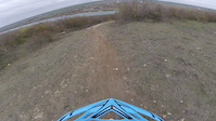
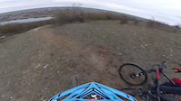
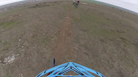
Photos of Constanta Mountain Bike
Recent Trail Reports
| status | trail | date | condition | info | user |
|---|---|---|---|---|---|
| Vulpea Medgidia | Nov 22, 2020 @ 5:34am Nov 22, 2020 | Ideal | munteanuHILL | ||
| Vulpea Medgidia | Nov 22, 2020 @ 5:34am Nov 22, 2020 | Ideal | munteanuHILL |
Activity Feed
| username | action | type | title | date |
|---|---|---|---|---|
| pufalot | update | region | activity #80035570 | Sep 10, 2025 @ 2:41am Sep 10, 2025 |
| pufalot | update | region | activity #80035563 | Sep 10, 2025 @ 2:41am Sep 10, 2025 |
| pufalot | update | region | activity #80035556 | Sep 10, 2025 @ 2:41am Sep 10, 2025 |
| pufalot | update | region | activity #80035553 | Sep 10, 2025 @ 2:40am Sep 10, 2025 |
| pufalot | update | region | activity #80035541 | Sep 10, 2025 @ 2:40am Sep 10, 2025 |
Recent Comments
| username | type | title | comment | date |
|---|---|---|---|---|
| trail | HARDCORE | Aug 25, 2022 @ 8:36am Aug 25, 2022 |
Activity Type Stats
| activitytype | trails | distance | descent | descent distance | total vertical | rating | global rank | state rank | photos | reports | routes | ridelogs |
|---|---|---|---|---|---|---|---|---|---|---|---|---|
| Mountain Bike | 9 | 16 miles | 820 ft | 7 miles | 574 ft | 8 | 5 | 1 | 1,059 | |||
| E-Bike | 5 | 16 miles | 643 ft | 7 miles | 558 ft | 5 | 1 | 6 | ||||
| Horse | 4 | 16 miles | 505 ft | 6 miles | 558 ft | 2 | 1 | |||||
| Hike | 8 | 16 miles | 682 ft | 7 miles | 574 ft | 2 | 29 | |||||
| Trail Running | 8 | 16 miles | 682 ft | 7 miles | 574 ft | 2 | 12 | |||||
| Dirtbike/Moto | 6 | 16 miles | 643 ft | 7 miles | 558 ft | 1 | 3 | 1 | ||||
| ATV/ORV/OHV | 4 | 15 miles | 282 ft | 6 miles | 535 ft | 1 | 1 | |||||
| Snowshoe | 1 | 6 miles | 167 ft | 3 miles | 187 ft | |||||||
| Downhill Ski | 1 | 6 miles | 167 ft | 3 miles | 187 ft | |||||||
| Backcountry Ski | 1 | 6 miles | 167 ft | 3 miles | 187 ft | |||||||
| Nordic Ski | 1 | 6 miles | 167 ft | 3 miles | 187 ft | 2 |
- By punksovereign & contributors
- Admins: pufalot
- #6372 - 4,146 views
- constanta activity log | embed map of Constanta mountain bike trails |
Downloading of trail gps tracks in kml & gpx formats is enabled for Constanta.
You must login to download files.