close
-
Layers w
- Weather Layers
- Pro
- Pro
- Pro
- Pro
- Pro
- Pro
- More Layers
- Pro
- Pro
- Pro
- Pro
-
Upgrade to

3D
Trail Conditions
- Unknown
- Snow Groomed
- Snow Packed
- Snow Covered
- Snow Cover Partial
- Freeze/thaw Cycle
- Icy
- Prevalent Mud
- Wet
- Variable
- Ideal
- Dry
- Very Dry
Trail Flow (Ridden Direction)
Trailforks scans users ridelogs to determine the most popular direction each trail is ridden. A good flowing trail network will have most trails flowing in a single direction according to their intension.
The colour categories are based on what percentage of riders are riding a trail in its intended direction.
The colour categories are based on what percentage of riders are riding a trail in its intended direction.
- > 96%
- > 90%
- > 80%
- > 70%
- > 50%
- < 50%
- bi-directional trail
- no data
Trail Last Ridden
Trailforks scans ridelogs to determine the last time a trail was ridden.
- < 2 days
- < 1 week
- < 2 weeks
- < 1 month
- < 6 months
- > 6 months
Trail Ridden Direction
The intended direction a trail should be ridden.
- Downhill Only
- Downhill Primary
- Both Directions
- Uphill Primary
- Uphill Only
- One Direction
Contribute Details
Colors indicate trail is missing specified detail.
- Description
- Photos
- Description & Photos
- Videos
Trail Popularity ?
Trailforks scans ridelogs to determine which trails are ridden the most in the last 9 months.
Trails are compared with nearby trails in the same city region with a possible 25 colour shades.
Think of this as a heatmap, more rides = more kinetic energy = warmer colors.
- most popular
- popular
- less popular
- not popular
ATV/ORV/OHV Filter
Max Vehicle Width
inches
US Cell Coverage
Legend

Radar Time
Activity Recordings
Trailforks uses anonymized public activity data.
?
Activity Recordings
Trailforks uses anonymized public activity data.
?
Personal Heatmap
▶
Activity Types
all
/
none
▶
Options
2
Date range
month
–
Winter Trails
Warning
A routing network for winter maps does not exist. Selecting trails using the winter trails layer has been disabled.
Missing Trails
Most Popular
Least Popular
Trails are colored based on popularity. The more popular a trail is, the more red. Less popular trails trend towards green.
Jump Magnitude Heatmap
Heatmap of where riders jump on trails. Zoom in to see individual jumps, click circles to view jump details.
BC Backroad Status
![map legend]()
Service Road Atlas is a free to use, community-driven service for viewing and creating reports on the numerous back-country service roads around B.C. and Alberta.

Slope Aspect
Direction the slope faces
Trails Deemphasized
Trails are shown in grey.
Only show trails with no bike usage.
Suggested Layers
Based on selected activity type
Save the current map location and zoom level as your default home location whenever this page is loaded.
SaveL’esistenza di Gemona del Friuli viene menzionata da Paolo Diacono nella sua “Historia Langobardorum”, il quale riporta che nel 611 era considerato un castello inespugnabile.
Fin dall’epoca preistorica, però, Gemona era uno dei punti di passaggio obbligati e più importanti della strada che dall’Adriatico si dirigeva verso i valichi alpini nord-orientali. La pianura dove oggi sono sviluppati gran parte degli insediamenti urbani una volta era dominata dalle paludi del fiume Tagliamento e il percorso più sicuro e obbligato era quello che prevedeva il passaggio per l’odierno centro storico per poi proseguire verso l’alto Friuli. I primi insediamenti celtici possono essere catalogati attorno al 500 a.C. nell’attuale borgata che oggi prende il nome di Godo. È proprio lì che tutt’oggi è ancora presente la fontana Silans (Silans in latino significa proprio fonte) che conferma ancor di più che anche in epoca romanica la via Julia Augusta attraversava questi territori, tesi avvalorata inoltre dai numerosi reperti archeologici che sono stati rinvenuti in quell’area.
Nella seconda metà del XII secolo fu libero comune, con propri statuti, mentre nel XIII e XIV secolo fu importante centro di traffici commerciali sotto il Patriarcato di Aquileia: con l’istituto del Niederlech (“scarico”), si imponeva infatti ai mercanti in transito di depositare le merci e pagarvi un dazio e di trascorrere la notte in città. La prosperità ne fece anche un centro di primaria importanza, arricchito da chiese e dimore signorili, con cinta muraria protetta da un castello.
Dopo la diminuzione dei traffici a seguito della conquista da parte della Repubblica di Venezia nel 1420 la cittadina ebbe un lungo periodo di declino, fino alla ripresa nella seconda metà del XX secolo.
Il comune di Gemona assunse la denominazione di Gemona del Friuli nel 1935.
Nel 1976 fu devastata dai terremoti del 6 maggio (quasi 4000 morti) e del 15 settembre, che provocarono il crollo di una parte del duomo, punto di riferimento per l’intera città, e del castello, attualmente in ricostruzione. Molti crolli furono favoriti dall’età avanzata degli edifici, che erano stati risparmiati dalle devastazioni delle guerre mondiali. Dopo il terremoto venne riedificata completamente con criteri antisismici diventando il simbolo del carattere friulano, tenace e laborioso,
È il comune più importante di un territorio che prende il nome di “Gemonese”, alle pendici delle Prealpi Giulie, comprendente i comuni di Artegna, Bordano, Buja, Montenars, Osoppo, Trasaghis e Venzone.
Il territorio comunale comprende zone geograficamente molto diverse: dalla pianura delle borgate di Campo Lessi, Taboga e Campagnola, a quelle più collinari di Ospedaletto e Stalis, per poi raggiungere una vasta area delle Prealpi Giulie. In quest’area infatti il territorio diventa montagnoso e il clima caratteristico delle zone di montagna. All’interno del Comune scorre il torrente Vegliato che, percorso la base del monte Cjampon, giunge fino alla zona pianeggiante della cittadina per poi essere incanalato prima in un alveo artificiale e per poi diventare la cosiddetta “roggia dei molini” da cui prendono il nome anche alcune zone come “Borgo Molino”.
source: Gemona del Friuli
Primary Trail Type: All-Mountain & Downhill
Shuttleable: YES
 google parking directions
This region uses the Uk/Euro style trail grading system.
Activities Click to view
- Mountain Bike
23 trails
- E-Bike
8 trails
- Hike
23 trails
- Trail Running
23 trails
Region Details
- 4
- 12
- 5
- 1
Region Status
Open as of Apr 29, 2026Stats
- Avg Trail Rating
- Trails (view details)
- 22
- Trails Mountain Bike
- 23
- Trails E-Bike
- 8
- Trails Hike
- 23
- Trails Trail Running
- 23
- Total Distance
- 24 miles
- Total Descent
- 15,227 ft
- Total Vertical
- 3,584 ft
- Highest Trailhead
- 4,398 ft
- Reports
- 372
- Photos
- 93
- Ridden Counter
- 2,081
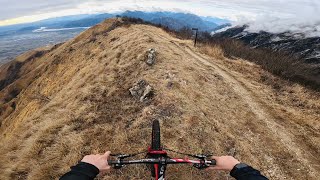
Popular Cuarnan Mountain Biking Trails
• 95 ★ 4.9 • 1 mile • 7 ft • 228 •
Highly rated popular red difficulty alpine singletrack. This mountain bike primary trail can be used downhill primary and has a moderate overall physical rating with a 7 ft blue climb. On average it takes 20 minutes to complete this trail.
• 90 ★ 4.9 • 3 miles • 290 ft • 176 •
Highly rated popular red difficulty alpine singletrack. This mountain bike primary trail can be used downhill primary and has a moderate overall physical rating with a 290 ft blue climb. On average it takes 30 minutes to complete this trail.
• 100 ★ 4.0 • 1,545 ft • 39 ft • 116 •
Popular blue difficulty singletrack. This mountain bike primary trail can be used downhill primary and has a moderate overall physical rating with a 39 ft blue climb. On average it takes 2 minutes to complete this trail.
• 80 ★ 4.1 • 2 miles • 68 ft • 111 •
Highly rated popular blue difficulty singletrack. This mountain bike primary trail can be used downhill primary and has a moderate overall physical rating with a 68 ft blue climb. It features drop, jump and rock garden. Trail visibility is always easy to follow. On average it takes 12 minutes to complete this trail.
• 70 ★ 5.0 • 1 mile • 240 ft • 84 •
Popular blue difficulty singletrack. This mountain bike primary trail can be used downhill primary and has a moderate overall physical rating with a 240 ft blue climb. On average it takes 6 minutes to complete this trail.
• 60 ★ 4.7 • 4,320 ft • 14 ft • 80 •
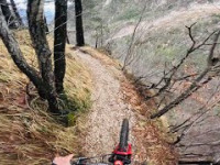
Nice, rocky & a little technical trail connecting strada foredor with the trails on the other side of Torrente . The trail often reminds me of the trails at lago di Garda. Extremely slippery when wet!
• 70 ★ 5.0 • 1,682 ft • 45 ft • 68 •
Popular blue difficulty singletrack. This mountain bike primary trail can be used downhill primary and has a moderate overall physical rating with a 45 ft blue climb. On average it takes 2 minutes to complete this trail.
• 45 ★ 3.6 • 2,825 ft • 4 ft • 66 •
Nice single-trail from the top of Cuarnan (north-path) down to Malga. It is a technical trail with lots of stones, loose stones, rocks and loose rocks. Some steep sections. Very slippery when wet. Only for experts if you already have...
Photos of Cuarnan Mountain Bike
Videos of Cuarnan Mountain Bike
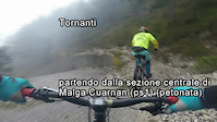
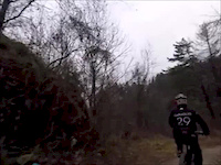
trail: Tornanti
11:48 |
254 |
Nov 10, 2018
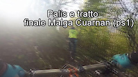
trail: Palis
3:24 |
55 |
Nov 5, 2018
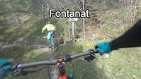
trail: Fontanat
3:02 |
129 |
Nov 4, 2018
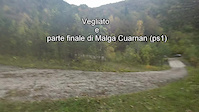
trail: Vegliato
9:45 |
250 |
Nov 4, 2018
trail: Panchine lungo (ps3)
3:46 |
294 |
Feb 8, 2017
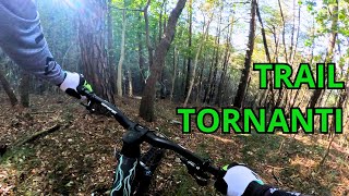
trail: Tornanti
7:46 |
144 |
Nov 1, 2024 , Gemona del Friuli
trail: Gobbe Trail
13:02 |
362 |
Mar 9, 2024 , Gemona del Friuli
trail: Cuarnan Sentiero Nord
6:22 |
158 |
Mar 8, 2024 , Gemona del Friuli
Recent Trail Reports
| status | trail | date | condition | info | user |
|---|---|---|---|---|---|
| Malga Cuarnan (ps1) | Apr 29, 2026 @ 7:30pm (Europe/Rome) Apr 29, 2026 | Ideal | Igorvisko | ||
| Cuarnan Sentiero Nord | Apr 29, 2026 @ 7:22pm (Europe/Rome) Apr 29, 2026 | Unknown | Igorvisko | ||
| Cuarnan Bike&Hike Uphill | Apr 29, 2026 @ 7:20pm (Europe/Rome) Apr 29, 2026 | Ideal | Igorvisko | ||
| Vegliato | Apr 23, 2026 @ 3:10pm (Europe/Rome) Apr 23, 2026 | Dry | Lambdo | ||
| Panchine lungo (ps3) | Feb 25, 2026 @ 3:11pm (Europe/Ljubljana) Feb 25, 2026 | Ideal | Fabrizior | ||
| Tornanti | Feb 12, 2026 @ 10:07am (Europe/Rome) Feb 12, 2026 | Ideal | LuigiPrimiceri | ||
| Fontanat | Feb 12, 2026 @ 10:06am (Europe/Rome) Feb 12, 2026 | Ideal | LuigiPrimiceri | ||
| Scalini | Nov 10, 2025 @ 12:46am (Pacific/Midway) Nov 10, 2025 | Ideal | harue | ||
| Gobbe Trail | Nov 10, 2025 @ 12:46am (Pacific/Midway) Nov 10, 2025 | Ideal | harue | ||
| Uphill Ôrs di Cuarnan | Jul 19, 2025 @ 1:35pm Jul 19, 2025 | Ideal | Marvillo66 |
Activity Feed
| username | action | type | title | date |
|---|---|---|---|---|
| raffaelemtb | ridden | trail | activity #96726415 | Jun 11, 2026 @ 3:30am 2 days |
| akichnakich | ridden | trail | activity #96456313 | Jun 7, 2026 @ 6:59am Jun 7, 2026 |
| TheSybenator | vote | trail | activity #96081007 and 1 more | Jun 2, 2026 @ 6:59am Jun 2, 2026 |
| Smourock17 | wishlist | trail | activity #95762377 | May 29, 2026 @ 1:44am May 29, 2026 |
| kosarjure | wishlist | trail | activity #95620213 | May 27, 2026 @ 1:50am May 27, 2026 |
Recent Comments
| username | type | title | comment | date |
|---|---|---|---|---|
| trail | The top section is fully natural. The lower... | Apr 29, 2026 @ 10:30am Apr 29, 2026 | ||
| trail | uphill auf Asphalt super angenehm zu fahren,... | Oct 6, 2023 @ 5:12am Oct 6, 2023 | ||
| trail | Full gas / straight down on nice rocky / rooty... | Sep 23, 2023 @ 9:41am Sep 23, 2023 | ||
| trail | Not worth the ride at the moment - so many... | Sep 23, 2023 @ 9:35am Sep 23, 2023 | ||
| trail | Wonderful | Jul 27, 2023 @ 6:49am Jul 27, 2023 |
Nearby Areas
| name | distance | ||||
|---|---|---|---|---|---|
| Cumieli | 5 | 9 | 1.2 km | ||
| Iof | 1 | 1 | 2.2 km | ||
| Faeit (Artegna) | 1 | 2 | 3.1 km | ||
| Faeit (Montenars) | 1 | 4 | 3.3 km | ||
| Campeon | 1 | 6 | 3.6 km |
Local Badges
-

Completionist0 awarded
Activity Type Stats
| activitytype | trails | distance | descent | descent distance | total vertical | rating | global rank | state rank | photos | reports | routes | ridelogs |
|---|---|---|---|---|---|---|---|---|---|---|---|---|
| Mountain Bike | 23 | 24 miles | 15,226 ft | 14 miles | 3,586 ft | #3,050 | #120 | 93 | 369 | 2,145 | ||
| E-Bike | 8 | 9 miles | 6,115 ft | 6 miles | 3,579 ft | #5,126 | #356 | 273 | 405 | |||
| Hike | 23 | 24 miles | 15,226 ft | 14 miles | 3,586 ft | #5,933 | #197 | 369 | 157 | |||
| Trail Running | 23 | 24 miles | 15,226 ft | 14 miles | 3,586 ft | #5,086 | #188 | 369 | 70 |
Frequently Asked Questions About Cuarnan
▼
What are the highest rated mountain biking trails in Cuarnan?
The highest rated mountain biking trails in Cuarnan are:
- Gobbe Trail (4.6/5)
- Malga Cuarnan (ps1) (4.6/5)
- Tornanti (4.2/5)
- FontaneTrasseit (4.2/5)
- Çuc dal Vieri (4.1/5)
▼
What is the best time of the year to ride in Cuarnan?
Based on ride log data, the most popular months to ride in Cuarnan are:
- May (11 activities)
- October (11 activities)
- November (10 activities)
▼
Where can I park to ride in Cuarnan?
▼
What is the longest trail in Cuarnan?
The longest trail in Cuarnan is Malga Cuarnan (ps1) at 2.7 miles. View all trails sorted by distance.
Activities
Trails
Points of Interest
- By maxmisdaris
 MGNR & contributors
 - Admins: apply
- #25851 - 4,580 views
- cuarnan activity log | embed map of Cuarnan mountain bike trails | cuarnan mountain biking points of interest
Downloading of trail gps tracks in kml & gpx formats is enabled for Cuarnan.
You must login to download files.