close
-
Layers w
- Map Content
- More Layers
- Pro
- Pro
- Pro
- Pro
- Pro
- Pro
- Pro
- Pro
-
Upgrade to

3D
Trail Conditions
- Unknown
- Snow Groomed
- Snow Packed
- Snow Covered
- Snow Cover Partial
- Freeze/thaw Cycle
- Icy
- Prevalent Mud
- Wet
- Variable
- Ideal
- Dry
- Very Dry
Trail Flow (Ridden Direction)
Trailforks scans users ridelogs to determine the most popular direction each trail is ridden. A good flowing trail network will have most trails flowing in a single direction according to their intension.
The colour categories are based on what percentage of riders are riding a trail in its intended direction.
The colour categories are based on what percentage of riders are riding a trail in its intended direction.
- > 96%
- > 90%
- > 80%
- > 70%
- > 50%
- < 50%
- bi-directional trail
- no data
Trail Last Ridden
Trailforks scans ridelogs to determine the last time a trail was ridden.
- < 2 days
- < 1 week
- < 2 weeks
- < 1 month
- < 6 months
- > 6 months
Trail Ridden Direction
The intended direction a trail should be ridden.
- Downhill Only
- Downhill Primary
- Both Directions
- Uphill Primary
- Uphill Only
- One Direction
Contribute Details
Colors indicate trail is missing specified detail.
- Description
- Photos
- Description & Photos
- Videos
Trail Popularity ?
Trailforks scans ridelogs to determine which trails are ridden the most in the last 9 months.
Trails are compared with nearby trails in the same city region with a possible 25 colour shades.
Think of this as a heatmap, more rides = more kinetic energy = warmer colors.
- most popular
- popular
- less popular
- not popular
ATV/ORV/OHV Filter
Max Vehicle Width
inches
US Cell Coverage
Legend

Radar Time
x
Activity Recordings
Trailforks users anonymized public ridelogs from the past 6 months.
- mountain biking recent
- mountain biking (>6 month)
- hiking (1 year)
- moto (1 year)
Activity Recordings
Trailforks users anonymized public skilogs from the past 12 months.
- Downhill Ski
- Backcountry Ski
- Nordic Ski
- Snowmobile
Winter Trails
Warning
A routing network for winter maps does not exist. Selecting trails using the winter trails layer has been disabled.
x
Missing Trails
Most Popular
Least Popular
Trails are colored based on popularity. The more popular a trail is, the more red. Less popular trails trend towards green.
Jump Magnitude Heatmap
Heatmap of where riders jump on trails. Zoom in to see individual jumps, click circles to view jump details.
Trails Deemphasized
Trails are shown in grey.
Only show trails with NO bikes.
Save the current map location and zoom level as your default home location whenever this page is loaded.
SaveDavagh Forest lies in an untouched rural landscape of rolling hills and sweeping forests.
Located approximately 6 miles north west of Cookstown, Davagh Forest offers gentle mountain biking and walking trails as well as an impressive 16km red trail with some rock slab drops you will never forget
The Davagh Forest Trails are a Cookstown District Council Facility.
Located approximately 6 miles north west of Cookstown, Davagh Forest offers gentle mountain biking and walking trails as well as an impressive 16km red trail with some rock slab drops you will never forget
The Davagh Forest Trails are a Cookstown District Council Facility.
source: Mountain Bike Northern Ireland
 google parking directions
This region uses the Uk/Euro style trail grading system.
Activities Click to view
- Mountain Bike
30 trails
- E-Bike
30 trails
- Hike
27 trails
- Trail Running
27 trails
Stats
- Avg Trail Rating
- Trails (view details)
- 30
- Trails Mountain Bike
- 30
- Trails E-Bike
- 30
- Trails Hike
- 27
- Trails Trail Running
- 27
- Total Distance
- 20 miles
- Total Descent
- 2,501 ft
- Total Vertical
- 667 ft
- Highest Trailhead
- 1,254 ft
- Reports
- 533
- Photos
- 60
- Ridden Counter
- 2,772
Popular Davagh Forest Mountain Biking Trails
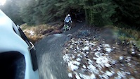
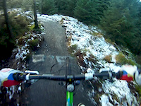
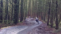
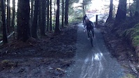
Photos of Davagh Forest Mountain Bike
trail: Car Wash
53 |
Jun 18, 2022 @ 11:27am
Jun 18, 2022
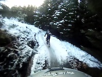
trail: Stream Trail
40 |
May 7, 2022 @ 5:29am
May 7, 2022
trail: Boundary Rock
34 |
May 2, 2022 @ 9:07am
May 2, 2022
trail: Wolf's Hill
46 |
May 2, 2022 @ 9:06am
May 2, 2022
trail: Golan
55 |
Dec 30, 2021 @ 3:34pm
Dec 30, 2021
trail: Wolf's Hill
40 |
Dec 18, 2021 @ 7:44am
Dec 18, 2021
trail: Stream Trail
50 |
Nov 1, 2021 @ 11:58am
Nov 1, 2021
trail: Blue Trail 1
27 |
Sep 18, 2021 @ 12:01pm
Sep 18, 2021Videos of Davagh Forest Mountain Bike

trail: Stream Trail
2:13 |
156 |
Jun 9, 2015

1:28 |
442 |
Jan 8, 2015

1:11 |
163 |
Jan 8, 2015
trail: Stream Trail
2:12 |
367 |
Jan 3, 2015
trail: Stream Trail
1:44 |
212 |
Jan 3, 2015
trail: Stream Trail
0:18 |
250 |
Jan 2, 2015
trail: Stream Trail
0:26 |
250 |
Jan 2, 2015
trail: Stream Trail
1:36 |
208 |
Dec 31, 2014
Recent Trail Reports
| status | trail | date | condition | info | user |
|---|---|---|---|---|---|
| 2nd Trail | Mar 26, 2024 @ 3:08pm Mar 26, 2024 | Wet | Pancake4 | ||
| Blue Trail 3 | Mar 18, 2024 @ 3:44am Mar 18, 2024 | Variable | cleggycyclist | ||
| Blue Trail 2 | Mar 18, 2024 @ 3:44am Mar 18, 2024 | Variable | cleggycyclist | ||
| Boundary Rock | Mar 18, 2024 @ 3:44am Mar 18, 2024 | Variable | cleggycyclist | ||
| Giant's Bed | Mar 18, 2024 @ 3:44am Mar 18, 2024 | Variable | cleggycyclist | ||
| Big Wig Jig | Mar 18, 2024 @ 3:44am Mar 18, 2024 | Variable | cleggycyclist | ||
| Beleevna | Mar 18, 2024 @ 3:44am Mar 18, 2024 | Variable | cleggycyclist | ||
| Beleev'in More | Mar 18, 2024 @ 3:44am Mar 18, 2024 | Wet | cleggycyclist | ||
| Stream Trail | Mar 18, 2024 @ 3:44am Mar 18, 2024 | Wet | cleggycyclist | ||
| Blue Trail 1 | Mar 18, 2024 @ 3:44am Mar 18, 2024 | Variable | cleggycyclist |
Activity Feed
| username | action | type | title | date |
|---|---|---|---|---|
| Darrenoconnell | ridden | trail | activity #52184299 | May 6, 2024 @ 1:02pm May 6, 2024 |
| cleggycyclist | add | video | activity #51422279 | Apr 19, 2024 @ 11:00pm Apr 19, 2024 |
| Pancake4 | add | report | activity #50501660 | Mar 26, 2024 @ 3:08pm Mar 26, 2024 |
| Pancake4 | ridden | trail | activity #50501496 | Mar 26, 2024 @ 3:04pm Mar 26, 2024 |
| cleggycyclist | add | report | activity #50179670 | Mar 19, 2024 @ 12:40am Mar 19, 2024 |
Recent Comments
| username | type | title | comment | date |
|---|---|---|---|---|
| report | All dry | Jun 8, 2018 @ 10:56am Jun 8, 2018 | ||
| trail | Best bit of the red but lacks any small jumps,... | Nov 18, 2014 @ 9:17am Nov 18, 2014 | ||
| trail | Groomed flat gravel surface with corner into... | Nov 18, 2014 @ 9:15am Nov 18, 2014 | ||
| trail | Groomed flat gravel surface with corner into... | Nov 18, 2014 @ 9:14am Nov 18, 2014 |
Nearby Areas
| name | distance | ||||
|---|---|---|---|---|---|
| Gortin Glen | 4 | 13.1 km | |||
| Garvagh forest | 6 | 20.2 km | |||
| Blessingbourne | 3 | 27.9 km | |||
| Binevenagh | 3 | 8 | 1 | 28.3 km | |
| Gosford Forest Park | 12 | 32.7 km |
Local Badges
-

Completionist10 awarded
Activity Type Stats
| activitytype | trails | distance | descent | descent distance | total vertical | rating | global rank | state rank | photos | reports | routes | ridelogs |
|---|---|---|---|---|---|---|---|---|---|---|---|---|
| Mountain Bike | 30 | 20 miles | 2,500 ft | 8 miles | 666 ft | #2,538 | #120 | 58 | 533 | 1,120 | ||
| E-Bike | 30 | 20 miles | 2,500 ft | 8 miles | 666 ft | #934 | #83 | 2 | 533 | 68 | ||
| Hike | 27 | 18 miles | 2,257 ft | 8 miles | 610 ft | #2,382 | #75 | 530 | 2 | |||
| Trail Running | 27 | 18 miles | 2,257 ft | 8 miles | 610 ft | #2,392 | #74 | 530 |
- By MountainBikeNI & contributors
- Admins: apply
- #4385 - 9,258 views
- davagh forest activity log | embed map of Davagh Forest mountain bike trails | davagh forest mountain biking points of interest
Downloading of trail gps tracks in kml & gpx formats is enabled for Davagh Forest.
You must login to download files.