close
-
Layers w
- Weather Layers
- Pro
- Pro
- Pro
- Pro
- Pro
- Pro
- More Layers
- Pro
- Pro
- Pro
- Pro
-
Upgrade to

3D
Trail Conditions
- Unknown
- Snow Groomed
- Snow Packed
- Snow Covered
- Snow Cover Partial
- Freeze/thaw Cycle
- Icy
- Prevalent Mud
- Wet
- Variable
- Ideal
- Dry
- Very Dry
Trail Flow (Ridden Direction)
Trailforks scans users ridelogs to determine the most popular direction each trail is ridden. A good flowing trail network will have most trails flowing in a single direction according to their intension.
The colour categories are based on what percentage of riders are riding a trail in its intended direction.
The colour categories are based on what percentage of riders are riding a trail in its intended direction.
- > 96%
- > 90%
- > 80%
- > 70%
- > 50%
- < 50%
- bi-directional trail
- no data
Trail Last Ridden
Trailforks scans ridelogs to determine the last time a trail was ridden.
- < 2 days
- < 1 week
- < 2 weeks
- < 1 month
- < 6 months
- > 6 months
Trail Ridden Direction
The intended direction a trail should be ridden.
- Downhill Only
- Downhill Primary
- Both Directions
- Uphill Primary
- Uphill Only
- One Direction
Contribute Details
Colors indicate trail is missing specified detail.
- Description
- Photos
- Description & Photos
- Videos
Trail Popularity ?
Trailforks scans ridelogs to determine which trails are ridden the most in the last 9 months.
Trails are compared with nearby trails in the same city region with a possible 25 colour shades.
Think of this as a heatmap, more rides = more kinetic energy = warmer colors.
- most popular
- popular
- less popular
- not popular
ATV/ORV/OHV Filter
Max Vehicle Width
inches
US Cell Coverage
Legend

Radar Time
Activity Recordings
Trailforks uses anonymized public activity data.
?
Activity Recordings
Trailforks uses anonymized public activity data.
?
Personal Heatmap
▶
Activity Types
all
/
none
▶
Options
2
Date range
month
–
Winter Trails
Warning
A routing network for winter maps does not exist. Selecting trails using the winter trails layer has been disabled.
Missing Trails
Most Popular
Least Popular
Trails are colored based on popularity. The more popular a trail is, the more red. Less popular trails trend towards green.
Jump Magnitude Heatmap
Heatmap of where riders jump on trails. Zoom in to see individual jumps, click circles to view jump details.
BC Backroad Status
![map legend]()
Service Road Atlas is a free to use, community-driven service for viewing and creating reports on the numerous back-country service roads around B.C. and Alberta.

Slope Aspect
Direction the slope faces
Trails Deemphasized
Trails are shown in grey.
Only show trails with no bike usage.
Suggested Layers
Based on selected activity type
Save the current map location and zoom level as your default home location whenever this page is loaded.
Save
No description for Ede has been added yet!
Login or register to submit one.
Activities Click to view
- Mountain Bike
88 trails
- E-Bike
48 trails
- Adaptive Bike
0 trails
- Horse
1 trails
- Hike
37 trails
- Trail Running
37 trails
Region Details
- 23
- 9
- 30
- 17
- 1
Region Status
Open as of Aug 21, 2025Stats
- Avg Trail Rating
- Trails (view details)
- 80
- Trails Mountain Bike
- 88
- Trails E-Bike
- 48
- Trails Horse
- 1
- Trails Hike
- 37
- Trails Trail Running
- 37
- Total Distance
- 50 miles
- Total Descent
- 1,749 ft
- Total Vertical
- 112 ft
- Highest Trailhead
- 191 ft
- Reports
- 344
- Photos
- 184
- Ridden Counter
- 26,056
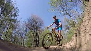
Popular Ede Mountain Biking Trails
• 100 ★ 0.0 • 5,002 ft • 40 ft • 595 •
easy to follow single trail. time to relax after all the jumps
• 90 ★ 0.0 • 2,680 ft • 31 ft • 432 •
Lunteren 2.0. Verbinding naar de kinder route.
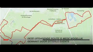
Ede Mountain Bike Routes
★ 4.0 • 23 miles • 428 ft • 8 •
The route in Ede is a combination of challenging trails (17 pieces), each with its own charm. The route...
★ 4.0 • 19 miles • 1,196 ft • 17 • Loop •
the complete track of the new MTB route in Lunteren. De complete track van de MTB route in Lunteren.
★ 5.0 • 3 miles • 109 ft • 0 • Loop •
In principle, this route was built especially for children, but also proved to be fun and challenging for...
Photos of Ede Mountain Bike
Videos of Ede Mountain Bike

trail: Zandgat Lunteren
4:56 |
48 |
Nov 8, 2020
trail: Zandgat Lunteren
0:38 |
107 |
Aug 18, 2012
youtuber
![MTB Challenge // Lunteren]()
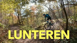
9:19 |
162 |
Jan 2, 2024
trail: Goudsberg
0:39 |
155 |
May 28, 2010
trail: Area 51
3:39 |
390 |
Nov 1, 2021 , Ede
trail: Area 51
4:32 |
230 |
Nov 1, 2021 , Ede

2:26 |
346 |
Jul 2, 2020
trail: Kids Loop Ede
0:53 |
516 |
Jul 2, 2020 , Ede
Recent Trail Reports
| status | trail | date | condition | info | user |
|---|---|---|---|---|---|
| Langs de renbaan | Aug 21, 2025 @ 9:41am Aug 21, 2025 | Ideal | RobHarmsen | ||
| Roekelse enk | Aug 21, 2025 @ 9:41am Aug 21, 2025 | Ideal | RobHarmsen | ||
| Naar Otterlo | Aug 21, 2025 @ 9:41am Aug 21, 2025 | Ideal | RobHarmsen | ||
| Binnendoor naar Immenweg | Aug 21, 2025 @ 9:41am Aug 21, 2025 | Ideal | RobHarmsen | ||
| Langs het middelpunt | Aug 21, 2025 @ 9:41am Aug 21, 2025 | Ideal | RobHarmsen | ||
| Goudsberg | Aug 21, 2025 @ 9:41am Aug 21, 2025 | Ideal | RobHarmsen | ||
| Zandgat Lunteren | Aug 21, 2025 @ 9:41am Aug 21, 2025 | Ideal | RobHarmsen | ||
| Lunterse Bosweg | Aug 21, 2025 @ 9:41am Aug 21, 2025 | Ideal | RobHarmsen | ||
| links er langs | Aug 21, 2025 @ 9:41am Aug 21, 2025 | Ideal | RobHarmsen | ||
| Langs de goorsteeg | Aug 21, 2025 @ 9:41am Aug 21, 2025 | Ideal | RobHarmsen |
Activity Feed
| username | action | type | title | date |
|---|---|---|---|---|
| SjeambecK | vote | trail | activity #88225416 and 5 more | Feb 2, 2026 @ 10:51am Feb 2, 2026 |
| Kroongj | add | photo | activity #83608202 | Nov 5, 2025 @ 2:37am Nov 5, 2025 |
| MartaD | wishlist | trail | activity #82888285 | Oct 23, 2025 @ 1:52pm Oct 23, 2025 |
| HowlingSnail | wishlist | route | activity #82398774 and 1 more | Oct 15, 2025 @ 10:45am Oct 15, 2025 |
| PeterBoer | wishlist | route | activity #81127481 | Sep 26, 2025 @ 6:53am Sep 26, 2025 |
Recent Comments
| username | type | title | comment | date |
|---|---|---|---|---|
| trail | Permanently closed! | Jan 30, 2024 @ 2:00pm Jan 30, 2024 |
Local Badges
-

Epic Ride Climb 2k7 awarded -

Climbing 10k Badge46 awarded -

Climbing 100k Badge2 awarded -

Epic Ride Descent 2k7 awarded -

Descent 10k Badge46 awarded -

Descent 100k Badge2 awarded
Activity Type Stats
| activitytype | trails | distance | descent | descent distance | total vertical | rating | global rank | state rank | photos | reports | routes | ridelogs |
|---|---|---|---|---|---|---|---|---|---|---|---|---|
| Mountain Bike | 88 | 50 miles | 1,749 ft | 16 miles | 112 ft | #880 | #2 | 184 | 344 | 4 | 11,604 | |
| E-Bike | 48 | 24 miles | 607 ft | 8 miles | 108 ft | #1,241 | #3 | 337 | 2 | 678 | ||
| Horse | 1 | 5,095 ft | 7 ft | 571 ft | 16 ft | #686 | #2 | |||||
| Hike | 37 | 17 miles | 302 ft | 5 miles | 108 ft | #2,295 | 336 | 421 | ||||
| Trail Running | 37 | 17 miles | 302 ft | 5 miles | 108 ft | #1,788 | #16 | 336 | 424 |
Frequently Asked Questions About Ede
▼
What are the highest rated mountain biking trails in Ede?
The highest rated mountain biking trails in Ede are:
- Naar de jump line (4.1/5)
- Roekelseweg (3.8/5)
- Langs de renbaan (3.8/5)
- Naar de koeweg (3.8/5)
- Naar Otterlo (3.8/5)
▼
What is the best time of the year to ride in Ede?
Based on ride log data, the most popular months to ride in Ede are:
- November (52 activities)
- October (44 activities)
- September (33 activities)
▼
Where can I park to ride in Ede?
▼
What is the longest trail in Ede?
The longest trail in Ede is MTB route ede 2.0 at 3.1 miles. View all trails sorted by distance.
Activities
Trails
Points of Interest
- By MTBDako & contributors
- Admins: apply
- #29390 - 4,379 views
- ede activity log | embed map of Ede mountain bike trails | ede mountain biking points of interest
Downloading of trail gps tracks in kml & gpx formats is enabled for Ede.
You must login to download files.