close
-
Layers w
- Weather Layers
- Pro
- Pro
- Pro
- Pro
- Pro
- Pro
- More Layers
- Pro
- Pro
- Pro
- Pro
-
Upgrade to

3D
Trail Conditions
- Unknown
- Snow Groomed
- Snow Packed
- Snow Covered
- Snow Cover Partial
- Freeze/thaw Cycle
- Icy
- Prevalent Mud
- Wet
- Variable
- Ideal
- Dry
- Very Dry
Trail Flow (Ridden Direction)
Trailforks scans users ridelogs to determine the most popular direction each trail is ridden. A good flowing trail network will have most trails flowing in a single direction according to their intension.
The colour categories are based on what percentage of riders are riding a trail in its intended direction.
The colour categories are based on what percentage of riders are riding a trail in its intended direction.
- > 96%
- > 90%
- > 80%
- > 70%
- > 50%
- < 50%
- bi-directional trail
- no data
Trail Last Ridden
Trailforks scans ridelogs to determine the last time a trail was ridden.
- < 2 days
- < 1 week
- < 2 weeks
- < 1 month
- < 6 months
- > 6 months
Trail Ridden Direction
The intended direction a trail should be ridden.
- Downhill Only
- Downhill Primary
- Both Directions
- Uphill Primary
- Uphill Only
- One Direction
Contribute Details
Colors indicate trail is missing specified detail.
- Description
- Photos
- Description & Photos
- Videos
Trail Popularity ?
Trailforks scans ridelogs to determine which trails are ridden the most in the last 9 months.
Trails are compared with nearby trails in the same city region with a possible 25 colour shades.
Think of this as a heatmap, more rides = more kinetic energy = warmer colors.
- most popular
- popular
- less popular
- not popular
ATV/ORV/OHV Filter
Max Vehicle Width
inches
US Cell Coverage
Legend

Radar Time
Activity Recordings
Trailforks uses anonymized public activity data.
?
Activity Recordings
Trailforks uses anonymized public activity data.
?
Personal Heatmap
▶
Activity Types
all
/
none
▶
Options
2
Date range
month
–
Winter Trails
Warning
A routing network for winter maps does not exist. Selecting trails using the winter trails layer has been disabled.
Missing Trails
Most Popular
Least Popular
Trails are colored based on popularity. The more popular a trail is, the more red. Less popular trails trend towards green.
Jump Magnitude Heatmap
Heatmap of where riders jump on trails. Zoom in to see individual jumps, click circles to view jump details.
BC Backroad Status
![map legend]()
Service Road Atlas is a free to use, community-driven service for viewing and creating reports on the numerous back-country service roads around B.C. and Alberta.

Slope Aspect
Direction the slope faces
Trails Deemphasized
Trails are shown in grey.
Only show trails with no bike usage.
Suggested Layers
Based on selected activity type
Save the current map location and zoom level as your default home location whenever this page is loaded.
Save
No description for Espoo has been added yet!
Login or register to submit one.
Activities Click to view
- Mountain Bike
1,170 trails
- E-Bike
1,167 trails
- Gravel Bike
4 trails
- Adaptive Bike
0 trails
- Winter Fat Bike
0 trails
- Hike
1,118 trails
- Trail Running
1,133 trails
- Nordic Ski
20 trails
Region Details
- 201
- 42
- 317
- 440
- 107
- 29
- 9
Region Status
Open as of Jun 10, 2026Stats
- Avg Trail Rating
- Trails (view details)
- 1,155
- Trails Mountain Bike
- 1,170
- Trails E-Bike
- 1,167
- Trails Gravel Bike
- 4
- Trails Horse
- 1
- Trails Hike
- 1,118
- Trails Trail Running
- 1,133
- Trails Dirtbike/Moto
- 3
- Trails Snowshoe
- 2
- Trails Backcountry Ski
- 3
- Trails Nordic Ski
- 20
- Total Distance
- 345 miles
- Total Descent
- 23,730 ft
- Total Vertical
- 353 ft
- Highest Trailhead
- 381 ft
- Reports
- 411
- Photos
- 56
- Ridden Counter
- 12,879
Sub Regions
-
Espoon Keskuspuisto
- 15
- 25
- 1
-
Karakallio
- 1
- 6
- 2
-
Kasavuori
- 1
- 1
- 1
-
Lintuvaara/Leppävaara
- 7
- 9
- 1
- 2
-
Lupauksenvuori
-
Nuuksio Bikepark
- 4
- 3
- 1
-
Nuuksion Alue
- 7
- 18
- 79
- 21
- 5
- 2
-
Vaakkoin Alue
- 2
- 6
- 18
- 31
- 4
- 2
Popular Espoo Mountain Biking Trails
• 100 ★ 0.0 • 1,617 ft • 0 ft • 82 •
Helppo flowtraili hyvillä bermeillä. Easy flowtrail with good berms.
• 100 ★ 0.0 • 2,287 ft • 8 ft • 79 •
Helppo enduroreitti metsän puolella. Semi easy enduro track in the forest.
• 90 ★ 4.2 • 4,226 ft • 19 ft • 78 •
Running mainly on top of a ridge. Steep rock face at west end. Going east is easier and more flowy. Full-suspension recommended for faster speeds.
• 100 ★ 0.0 • 541 ft • 0 ft • 75 •
Popular blue difficulty singletrack. This mountain bike primary trail can be used both directions and has a moderate overall physical rating with a 0 ft blue climb. On average it takes 1 minutes to complete this trail.
• 100 ★ 4.0 • 1,765 ft • 51 ft • 74 •
EKP 4.2 km reitin ensimmäinen osuus. Pääosin suht helppoa polkua mutta muutamia haastavia kivikoita matkalla.
• 100 ★ 4.5 • 2,897 ft • 22 ft • 72 •
EKP 4.2 km reitin neljäs osio. Pääosin helppoa hiekkapohjaista neulaspolkua muutamilla kivikkokohdilla ja hyppyreillä maustettuna(voi kiertää).
Espoo Mountain Bike Routes
26 miles • 1,356 ft • 13 • Loop •
Real mountainbiking. Not a lot of easy trails. Mostly can be ridden throughout except a few a spots. Can...
31 miles • 1,742 ft • 5 • Loop •
Famous Reitti2000 route. 50km long with mostly gravel but also some difficult mtb trails. Can be done on...
14 miles • 635 ft • 4 • Loop •
Luukki MTB event half marathon length. Difficult trails for the first half second half return gravel and...
5 miles • 360 ft • 10 • Point to Point •
City maintained MTB trail. A mixed trail with some demanding parts and lots of long easy parts.
10 miles • 511 ft • 7 • Loop •
Longer mtb route from Rinnekoti side. Start is difficult with rocky and rooty trails that are possible to...
Photos of Espoo Mountain Bike
Videos of Espoo Mountain Bike
trail: Easy Rider
17:53 |
212 |
Feb 8, 2013
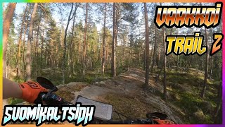
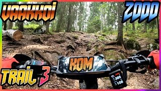
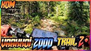
trail: Vaakkoi Suomi Kaltsi
0:58 |
64 |
Feb 27, 2025 , Espoo
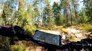
trail: Vaakkoi VanhaUra
2:00 |
104 |
Mar 18, 2024 , Espoo
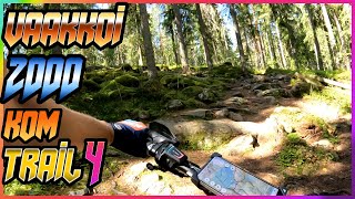
trail: Vaakkoi KarkeaPolku
11:56 |
112 |
Feb 14, 2024 , Espoo
trail: Åvalla-Majalammenranta
7:26 |
211 |
Feb 13, 2024 , Espoo
trail: Rinnekoti MaurinKauppa
4:45 |
73 |
Feb 6, 2024 , Espoo

trail: Up and Down
3:09 |
356 |
Nov 1, 2009
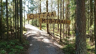
trail: Oittaa MTB-Trail
4:51 |
1278 |
Aug 12, 2020 , Espoo
Recent Trail Reports
| status | trail | date | condition | info | user |
|---|---|---|---|---|---|
| Nupuri Kalmari | Jun 10, 2026 @ 7:09pm (Europe/Helsinki) Jun 10, 2026 | Ideal | Larppamatic | ||
| Oittaa KovaMärkä | Jun 10, 2026 @ 7:09pm (Europe/Helsinki) Jun 10, 2026 | Ideal | Larppamatic | ||
| Nuuksio Kaltsila | Jun 10, 2026 @ 7:09pm (Europe/Helsinki) Jun 10, 2026 | Ideal | Larppamatic | ||
| Monikon myötäpäivä | May 17, 2026 @ 2:07pm (Europe/Helsinki) May 17, 2026 | Ideal | dameran | ||
| Hämevaara Vatulation | May 17, 2026 @ 2:06pm (Europe/Helsinki) May 17, 2026 | Ideal | dameran | ||
| Koivuvaara Maseria | May 15, 2026 @ 9:05pm (Europe/Helsinki) May 15, 2026 | Ideal | dameran | ||
| Snakes on a Plane | Oct 4, 2025 @ 11:34am (Europe/Helsinki) Oct 4, 2025 | Ideal | mcharza | ||
| Gump | Oct 4, 2025 @ 11:34am (Europe/Helsinki) Oct 4, 2025 | Ideal | mcharza | ||
| Easy Rider | Oct 4, 2025 @ 11:34am (Europe/Helsinki) Oct 4, 2025 | Ideal | mcharza | ||
| JokuSivu | Oct 4, 2025 @ 11:34am (Europe/Helsinki) Oct 4, 2025 | Ideal | mcharza |
Activity Feed
| username | action | type | title | date |
|---|---|---|---|---|
| schoutenroel | wishlist | trail | activity #98249320 | Jul 1, 2026 @ 11:16pm 11 hours |
| qlUuxf | ridden | trail | activity #97616212 and 4 more | Jun 23, 2026 @ 3:59am Jun 23, 2026 |
| Larppamatic | add | report | activity #96724188 | Jun 11, 2026 @ 1:50am Jun 11, 2026 |
| Larppamatic | add | report | activity #96724187 and 1 more | Jun 11, 2026 @ 1:50am Jun 11, 2026 |
| MiikkuAGlbLE | add | trail | activity #96028263 and 2 more | Jun 1, 2026 @ 10:51am Jun 1, 2026 |
Recent Comments
| username | type | title | comment | date |
|---|---|---|---|---|
| trail | Unfortunately interrupted/destroyed by the... | Sep 2, 2024 @ 10:24pm Sep 2, 2024 | ||
| trail | At the swimming pool side after the last turn... | Jun 23, 2024 @ 1:53am Jun 23, 2024 | ||
| trail | Short very steep section prevents riding it... | Aug 23, 2023 @ 11:38am Aug 23, 2023 | ||
| trail | I've been riding this for a long time, it is a... | Oct 25, 2020 @ 8:28am Oct 25, 2020 | ||
| trail | Makia sopivan tekninen kalliobaana komeilla... | Sep 28, 2020 @ 11:48am Sep 28, 2020 |
Local Badges
-

Completionist0 awarded -

Epic Ride 50k500 awarded -

Top 10 Trails1 awarded -
Completionist0 awarded -
Completionist0 awarded -

10 Expert Trails1 awarded
Activity Type Stats
| activitytype | trails | distance | descent | descent distance | total vertical | rating | global rank | state rank | photos | reports | routes | ridelogs |
|---|---|---|---|---|---|---|---|---|---|---|---|---|
| Mountain Bike | 1,170 | 343 miles | 23,717 ft | 151 miles | 354 ft | #90 | #1 | 56 | 409 | 11 | 12,718 | |
| E-Bike | 1,167 | 345 miles | 23,730 ft | 151 miles | 354 ft | #36 | #2 | 389 | 8 | 2,287 | ||
| Gravel Bike | 4 | #202 | #10 | 114 | ||||||||
| Horse | 1 | 1,467 ft | 26 ft | 1,371 ft | 26 ft | 27 | ||||||
| Hike | 1,118 | 331 miles | 21,037 ft | 144 miles | 354 ft | #131 | #2 | 389 | 1 | 417 | ||
| Trail Running | 1,133 | 334 miles | 21,401 ft | 146 miles | 354 ft | #92 | #2 | 390 | 1 | 1,179 | ||
| Dirtbike/Moto | 3 | 1 mile | 72 ft | 2,949 ft | 66 ft | 27 | 1 | |||||
| Snowshoe | 2 | 4 miles | 190 ft | 2 miles | 75 ft | 1 | 2 | |||||
| Backcountry Ski | 3 | 6 miles | 312 ft | 2 miles | 128 ft | 1 | 4 | |||||
| Nordic Ski | 20 | 6 miles | 318 ft | 2 miles | 144 ft | #213 | #7 | 1 | 613 |
Frequently Asked Questions About Espoo
▼
What are the best places to ride in Espoo?
Espoo has 8 areas to explore for mountain biking. The top rated areas are:
▼
What are the highest rated mountain biking trails in Espoo?
The highest rated mountain biking trails in Espoo are:
- MTB Latokaski 2 (4.1/5)
- Kaskipuu Alamäki1 (4.1/5)
- Up and Down (4.1/5)
- Tuoppimäki climb/roll (4.1/5)
- MTB Kaupunginkallio (4.1/5)
▼
What is the best time of the year to ride in Espoo?
Based on ride log data, the most popular months to ride in Espoo are:
- July (121 activities)
- June (65 activities)
- May (56 activities)
▼
Where can I park to ride in Espoo?
There are 33 parking locations listed in Espoo. The most popular parking spots are:
- Solvalla Swinghill Parking
- Puolarmaarin parkkipaikka
- Espoonkartano Parkkis
- Pirttimäki Parkkis
- Haukkalampi Parking West
Activities
Trails
- By brenthillier
 NSMBA TRAILFORKS & contributors
 - Admins: Bunabe
- #10102 - 10,851 views
- espoo activity log | embed map of Espoo mountain bike trails | espoo mountain biking points of interest
Downloading of trail gps tracks in kml & gpx formats is enabled for Espoo.
You must login to download files.