close
-
Layers w
- Weather Layers
- Pro
- Pro
- Pro
- Pro
- Pro
- Pro
- More Layers
- Pro
- Pro
- Pro
- Pro
-
Upgrade to

3D
Trail Conditions
- Unknown
- Snow Groomed
- Snow Packed
- Snow Covered
- Snow Cover Partial
- Freeze/thaw Cycle
- Icy
- Prevalent Mud
- Wet
- Variable
- Ideal
- Dry
- Very Dry
Trail Flow (Ridden Direction)
Trailforks scans users ridelogs to determine the most popular direction each trail is ridden. A good flowing trail network will have most trails flowing in a single direction according to their intension.
The colour categories are based on what percentage of riders are riding a trail in its intended direction.
The colour categories are based on what percentage of riders are riding a trail in its intended direction.
- > 96%
- > 90%
- > 80%
- > 70%
- > 50%
- < 50%
- bi-directional trail
- no data
Trail Last Ridden
Trailforks scans ridelogs to determine the last time a trail was ridden.
- < 2 days
- < 1 week
- < 2 weeks
- < 1 month
- < 6 months
- > 6 months
Trail Ridden Direction
The intended direction a trail should be ridden.
- Downhill Only
- Downhill Primary
- Both Directions
- Uphill Primary
- Uphill Only
- One Direction
Contribute Details
Colors indicate trail is missing specified detail.
- Description
- Photos
- Description & Photos
- Videos
Trail Popularity ?
Trailforks scans ridelogs to determine which trails are ridden the most in the last 9 months.
Trails are compared with nearby trails in the same city region with a possible 25 colour shades.
Think of this as a heatmap, more rides = more kinetic energy = warmer colors.
- most popular
- popular
- less popular
- not popular
ATV/ORV/OHV Filter
Max Vehicle Width
inches
US Cell Coverage
Legend

Radar Time
Activity Recordings
Trailforks uses anonymized public activity data.
?
Activity Recordings
Trailforks uses anonymized public activity data.
?
Personal Heatmap
▶
Activity Types
all
/
none
▶
Options
2
Date range
month
–
Winter Trails
Warning
A routing network for winter maps does not exist. Selecting trails using the winter trails layer has been disabled.
Missing Trails
Most Popular
Least Popular
Trails are colored based on popularity. The more popular a trail is, the more red. Less popular trails trend towards green.
Jump Magnitude Heatmap
Heatmap of where riders jump on trails. Zoom in to see individual jumps, click circles to view jump details.
BC Backroad Status
![map legend]()
Service Road Atlas is a free to use, community-driven service for viewing and creating reports on the numerous back-country service roads around B.C. and Alberta.

Slope Aspect
Direction the slope faces
Trails Deemphasized
Trails are shown in grey.
Only show trails with no bike usage.
Suggested Layers
Based on selected activity type
Save the current map location and zoom level as your default home location whenever this page is loaded.
Save
No description for Follonica has been added yet!
Login or register to submit one.
This region uses the Uk/Euro style trail grading system.
Activities Click to view
- Mountain Bike
190 trails
- E-Bike
190 trails
- Adaptive Bike
0 trails
- Winter Fat Bike
0 trails
- Hike
147 trails
- Trail Running
144 trails
Region Details
- 59
- 37
- 49
- 43
Region Status
Caution as of Jun 7, 2026Stats
- Avg Trail Rating
- Trails (view details)
- 188
- Trails Mountain Bike
- 191
- Trails E-Bike
- 190
- Trails Horse
- 3
- Trails Hike
- 147
- Trails Trail Running
- 144
- Trails Dirtbike/Moto
- 1
- Total Distance
- 97 miles
- Total Descent
- 17,960 ft
- Total Vertical
- 914 ft
- Highest Trailhead
- 941 ft
- Reports
- 969
- Photos
- 48
- Ridden Counter
- 9,113
Sub Regions
-
Montioni Trail Park
- 2
- 47
- 41
Popular Follonica Mountain Biking Trails
• 100 ★ 3.0 • 1,214 ft • 10 ft • 319 •
Popular white difficulty family friendly asphalt/tarmac road. This multi-use trail can be used one direction.
• 100 ★ 3.0 • 2 miles • 17 ft • 246 •
Popular white difficulty family friendly asphalt/tarmac road. This multi-use trail can be used both directions.
• 90 ★ 2.7 • 1 mile • 92 ft • 210 •
Popular green difficulty singletrack. This mountain bike primary trail can be used downhill primary and has a moderate overall physical rating with a 92 ft blue climb. Trail visibility is always easy to follow. On average it takes 9 minutes to complete this trail.
• 100 ★ 3.0 • 3,586 ft • 7 ft • 198 •
Popular white difficulty family friendly asphalt/tarmac road. This multi-use trail can be used both directions.
• 85 ★ 2.0 • 2 miles • 212 ft • 178 •
Popular green difficulty singletrack. This mountain bike primary trail can be used both directions and has a easy overall physical rating. Trail visibility is always easy to follow. On average it takes 12 minutes to complete this trail.
Follonica Mountain Bike Routes
17 miles • 2,098 ft • 5 •
Route in Park through the trails (13a) and (11a). Passage and visit on the tower of (old church)
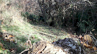
Photos of Follonica Mountain Bike
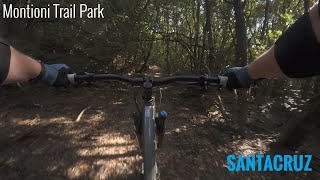
Videos of Follonica Mountain Bike
trail: Santacruz
0:34 |
206 |
Feb 26, 2016
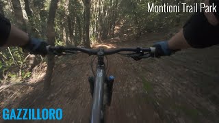
trail: Gazzilloro
8:19 |
148 |
Jan 5, 2025 , Follonica
trail: Santacruz
8:09 |
180 |
Jan 5, 2025 , Follonica
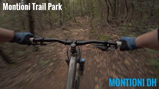
trail: Montioni Dh
11:46 |
139 |
Jan 5, 2025 , Follonica
trail: Bimbo
0:33 |
289 |
Feb 5, 2023 , Follonica
Current Trail Warnings
| status | trail | date | condition | user | info |
|---|---|---|---|---|---|
| Poggio Vacca | May 16, 2026 @ 10:21pm (Europe/Rome) May 16, 2026 | Variable | CypisSilesia | E-Bike The path is overgrown and washed out in... |
Recent Trail Reports
Activity Feed
| username | action | type | title | date |
|---|---|---|---|---|
| Antonio5voywX | ridden | trail | activity #96863346 | Jun 13, 2026 @ 4:48am 20 hours |
| Edwinsimo | add | report | activity #96445336 | Jun 7, 2026 @ 4:16am Jun 7, 2026 |
| FabianzfnF8P | ridden | trail | activity #96108753 | Jun 2, 2026 @ 2:07pm Jun 2, 2026 |
| raffa | ridden | trail | activity #95845745 and 7 more | May 30, 2026 @ 6:35am May 30, 2026 |
| Franos | ridden | trail | activity #95437609 | May 24, 2026 @ 12:47pm May 24, 2026 |
Recent Comments
| username | type | title | comment | date |
|---|---|---|---|---|
| trail | Ziemlich nice für kids | Oct 6, 2025 @ 4:46am Oct 6, 2025 | ||
| trail | Toller Trail, paar mal auf den Kopf achten... | Oct 6, 2025 @ 4:21am Oct 6, 2025 | ||
| trail | Unfahrbar, so verwachsen. Spassiger zu Fuss... | Oct 6, 2025 @ 3:19am Oct 6, 2025 | ||
| trail | Ziemlich verwachsen, sonst ok. | Oct 6, 2025 @ 2:53am Oct 6, 2025 | ||
| trail | Nice and Long trail. The section between... | Sep 26, 2025 @ 12:38pm Sep 26, 2025 |
Local Badges
-

Completionist0 awarded -

10 Blue Trails40 awarded -

Epic Mountain Bike Climb 2k6 awarded -

Climbing 10k Badge18 awarded -

Mountain Biking 100k Badge0 awarded -

Epic Ride Descent 2k6 awarded
Activity Type Stats
| activitytype | trails | distance | descent | descent distance | total vertical | rating | global rank | state rank | photos | reports | routes | ridelogs |
|---|---|---|---|---|---|---|---|---|---|---|---|---|
| Mountain Bike | 190 | 97 miles | 17,959 ft | 50 miles | 915 ft | #1,176 | #26 | 40 | 969 | 3,760 | ||
| E-Bike | 190 | 97 miles | 17,936 ft | 50 miles | 915 ft | #1,041 | #136 | 8 | 922 | 1,060 | ||
| Horse | 3 | 3 miles | 604 ft | 2 miles | 410 ft | 20 | ||||||
| Hike | 147 | 77 miles | 12,927 ft | 39 miles | 915 ft | #2,532 | #82 | 934 | 27 | |||
| Trail Running | 144 | 75 miles | 12,549 ft | 38 miles | 915 ft | #2,174 | #65 | 932 | 142 | |||
| Dirtbike/Moto | 1 | 3 miles | 75 ft | 2,044 ft | 656 ft | 12 |
Frequently Asked Questions About Follonica
▼
What are the best places to ride in Follonica?
Follonica has 1 areas to explore for mountain biking. The top rated areas are:
▼
What are the highest rated mountain biking trails in Follonica?
The highest rated mountain biking trails in Follonica are:
- Ritrovato (4.4/5)
- Tenerino (4.2/5)
- Flipper (4.2/5)
- Buddha (4.2/5)
- Montioni Dh (4.2/5)
▼
What is the best time of the year to ride in Follonica?
Based on ride log data, the most popular months to ride in Follonica are:
- October (27 activities)
- November (15 activities)
- January (15 activities)
▼
Where can I park to ride in Follonica?
There are 5 parking locations listed in Follonica. The most popular parking spots are: View all parking and trailhead locations on the map to plan your visit.
Activities
Trails
Points of Interest
- By ueppaa
 & contributors
 - Admins: DanielePracchia, ueppaa
- #40293 - 6,930 views
- follonica activity log | embed map of Follonica mountain bike trails | follonica mountain biking points of interest
Downloading of trail gps tracks in kml & gpx formats is enabled for Follonica.
You must login to download files.