close
-
Layers w
- Weather Layers
- Pro
- Pro
- Pro
- Pro
- Pro
- Pro
- More Layers
- Pro
- Pro
- Pro
- Pro
-
Upgrade to

3D
Trail Conditions
- Unknown
- Snow Groomed
- Snow Packed
- Snow Covered
- Snow Cover Partial
- Freeze/thaw Cycle
- Icy
- Prevalent Mud
- Wet
- Variable
- Ideal
- Dry
- Very Dry
Trail Flow (Ridden Direction)
Trailforks scans users ridelogs to determine the most popular direction each trail is ridden. A good flowing trail network will have most trails flowing in a single direction according to their intension.
The colour categories are based on what percentage of riders are riding a trail in its intended direction.
The colour categories are based on what percentage of riders are riding a trail in its intended direction.
- > 96%
- > 90%
- > 80%
- > 70%
- > 50%
- < 50%
- bi-directional trail
- no data
Trail Last Ridden
Trailforks scans ridelogs to determine the last time a trail was ridden.
- < 2 days
- < 1 week
- < 2 weeks
- < 1 month
- < 6 months
- > 6 months
Trail Ridden Direction
The intended direction a trail should be ridden.
- Downhill Only
- Downhill Primary
- Both Directions
- Uphill Primary
- Uphill Only
- One Direction
Contribute Details
Colors indicate trail is missing specified detail.
- Description
- Photos
- Description & Photos
- Videos
Trail Popularity ?
Trailforks scans ridelogs to determine which trails are ridden the most in the last 9 months.
Trails are compared with nearby trails in the same city region with a possible 25 colour shades.
Think of this as a heatmap, more rides = more kinetic energy = warmer colors.
- most popular
- popular
- less popular
- not popular
ATV/ORV/OHV Filter
Max Vehicle Width
inches
US Cell Coverage
Legend

Radar Time
Activity Recordings
Trailforks uses anonymized public activity data.
?
Activity Recordings
Trailforks uses anonymized public activity data.
?
Personal Heatmap
▶
Activity Types
all
/
none
▶
Options
2
Date range
month
–
Winter Trails
Warning
A routing network for winter maps does not exist. Selecting trails using the winter trails layer has been disabled.
Missing Trails
Most Popular
Least Popular
Trails are colored based on popularity. The more popular a trail is, the more red. Less popular trails trend towards green.
Jump Magnitude Heatmap
Heatmap of where riders jump on trails. Zoom in to see individual jumps, click circles to view jump details.
BC Backroad Status
![map legend]()
Service Road Atlas is a free to use, community-driven service for viewing and creating reports on the numerous back-country service roads around B.C. and Alberta.

Slope Aspect
Direction the slope faces
Trails Deemphasized
Trails are shown in grey.
Only show trails with no bike usage.
Suggested Layers
Based on selected activity type
Save the current map location and zoom level as your default home location whenever this page is loaded.
SaveThe Grants area encompasses the Mt. Taylor, Zuni Mountains and El Malpais riding areas.
Activities Click to view
- Mountain Bike
52 trails
- E-Bike
46 trails
- Gravel Bike
13 trails
- Adaptive Bike
0 trails
- Winter Fat Bike
0 trails
- Horse
19 trails
- Hike
65 trails
- Trail Running
63 trails
- Dirtbike/Moto
3 trails
- ATV/ORV/OHV
4 trails
- Snowmobile
0 trails
- Snowshoe
0 trails
- Backcountry Ski
0 trails
- Nordic Ski
0 trails
Region Details
- 28
- 7
- 12
- 3
Region Status
Caution as of Mar 14, 2026Stats
- Avg Trail Rating
- Trails (view details)
- 63
- Trails Mountain Bike
- 52
- Trails E-Bike
- 46
- Trails Gravel Bike
- 13
- Trails Horse
- 19
- Trails Hike
- 65
- Trails Trail Running
- 63
- Trails Dirtbike/Moto
- 3
- Trails ATV/ORV/OHV
- 4
- Total Distance
- 248 miles
- Total Descent Distance
- 98 miles
- Total Descent
- 19,798 ft
- Total Vertical
- 4,792 ft
- Highest Trailhead
- 11,292 ft
- Reports
- 99
- Photos
- 76
- Ridden Counter
- 522
Sub Regions
-
El Malpais National Conservation Area
- 2
- 4
-
Lobo Canyon Trails
- 4
-
Quartz Hill
- 1
- 4
-
San Mateo Mountains (Mount Taylor / CDT)
- 3
- 3
Popular Grants Mountain Biking Trails
• 95 ★ 3.4 • 7 miles • 585 ft • 34 •
Popular blue difficulty singletrack. This mountain bike primary trail can be used both directions. On average it takes 57 minutes to complete this trail.
• 100 ★ 4.2 • 6 miles • 416 ft • 29 •
Popular green difficulty singletrack. This mountain bike primary trail can be used downhill only. On average it takes 48 minutes to complete this trail.
• 90 ★ 3.7 • 6 miles • 577 ft • 25 •
Popular blue difficulty singletrack. This mountain bike primary trail can be used downhill only. On average it takes 1 hour28 minutes to complete this trail.
• 75 ★ 3.5 • 3 miles • 14 ft • 16 •
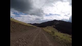
Trail descends from the summit of Mount Taylor. Starts out with spectacular views over a loose and rocky trail that soon becomes seriously rutted before heading into the tress for a fun run. Watch out for the gate! Links back to the FR...
• 60 ★ 3.0 • 1,811 ft • 312 ft • 15 •
Single track climb to the summit of Mount Taylor. Steep and unrideable in some places.
• 5 ★ 2.0 • 11 miles • 109 ft • 10 •
Less popular blue difficulty singletrack. This multi-use trail can be used both directions and has a moderate overall physical rating with a 109 ft blue climb. Trail visibility is always easy to follow. On average it takes 1 hour39 minutes to complete this trail.
• 85 ★ 5.0 • 3 miles • 90 ft • 6 •
Recently constructed and opened in summer of 2025, this trail is fun and flowy with a few punchy climbs.
• ★ 0.0 • 7 miles • 721 ft • 5 •
Blue difficulty singletrack. This mountain bike primary trail can be used downhill only.
Photos of Grants Mountain Bike
Videos of Grants Mountain Bike
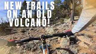
trail: Slow Yer Roll
19:33 |
25 |
Apr 9, 2026 , Grants
7:23 |
112 |
Sep 3, 2023
5:17 |
121 |
Jul 4, 2023
Recent Trail Reports
| status | trail | date | condition | info | user |
|---|---|---|---|---|---|
| Cinder Cone | Mar 14, 2026 @ 4:18pm (America/Denver) Mar 14, 2026 | Ideal | Bmxbikemike | ||
| Capulin Canyon | Mar 14, 2026 @ 4:18pm (America/Denver) Mar 14, 2026 | Ideal | Bmxbikemike | ||
| Easy Street | Oct 26, 2025 @ 10:46am (America/New_York) Oct 26, 2025 | Dry | mappermook TRAILFORKS | ||
| The Light (2) | Oct 3, 2025 @ 9:52am (America/New_York) Oct 3, 2025 | Ideal | mtbiker2859 | ||
| CDT (Cibola NM 21) | Sep 16, 2025 @ 9:12am (America/Denver) Sep 16, 2025 | Unknown | markegge | ||
| Chain of Craters Backcountry Byway 2 | Aug 24, 2025 @ 9:01am Aug 24, 2025 | Ideal | FattieMcFat MFBS | ||
| CDT (Chain of Craters 3) | Aug 24, 2025 @ 9:02am Aug 24, 2025 | Ideal | TerraFormer MFBS | ||
| Slow Yer Roll | Jul 9, 2025 @ 12:52pm Jul 9, 2025 | Ideal | Bmxbikemike | ||
| 6th Street Rail Trail | Feb 8, 2025 @ 10:43am Feb 8, 2025 | Ideal | brucerioux WACH NEMBA | ||
| Life on the Edge | Dec 27, 2020 @ 11:36am Dec 27, 2020 | Prevalent Mud | Mathematicus |
National Scenic Trails & Official Routes
-
Continental Divide Trail
- Mountain Bike
- Hike
- Trail Running

Activity Feed
| username | action | type | title | date |
|---|---|---|---|---|
| crottesen | wishlist | trail | activity #96606289 | Jun 9, 2026 @ 8:03am Jun 9, 2026 |
| WillieJacobsz | update | directory | activity #96297246 | Jun 5, 2026 @ 8:13am Jun 5, 2026 |
| wcR06U | wishlist | trail | activity #95022109 | May 18, 2026 @ 10:49pm May 18, 2026 |
| CheapThrills | add | photo | activity #94687843 and 3 more | May 14, 2026 @ 7:17am May 14, 2026 |
| samilton27 | add | video | activity #92254166 | Apr 9, 2026 @ 8:14am Apr 9, 2026 |
Recent Comments
| username | type | title | comment | date |
|---|---|---|---|---|
| trail | What a gem!! We were traveling from El Malpais... | Apr 13, 2025 @ 2:24pm Apr 13, 2025 | ||
| trail | Rode July 2, 2022. Lucky to meet Cibola Trail... | Jul 3, 2022 @ 7:21pm Jul 3, 2022 |
Local Badges
-

Epic Ride Descent 2k13 awarded -

Descent 10k Badge1 awarded -

Descent 100k Badge0 awarded -

Epic Mountain Bike Climb 2k12 awarded -

Climbing 10k Badge0 awarded -

Mountain Biking 100k Badge0 awarded
Activity Type Stats
| activitytype | trails | distance | descent | descent distance | total vertical | rating | global rank | state rank | photos | reports | routes | ridelogs |
|---|---|---|---|---|---|---|---|---|---|---|---|---|
| Mountain Bike | 52 | 236 miles | 18,675 ft | 92 miles | 4,793 ft | #1,581 | #594 | 73 | 99 | 601 | ||
| E-Bike | 46 | 206 miles | 16,220 ft | 82 miles | 4,793 ft | #790 | #765 | 80 | 9 | |||
| Gravel Bike | 13 | 55 miles | 4,409 ft | 23 miles | 4,465 ft | #329 | #924 | 2 | 24 | |||
| Horse | 19 | 123 miles | 9,724 ft | 42 miles | 4,088 ft | #486 | #498 | 14 | ||||
| Hike | 65 | 248 miles | 19,797 ft | 98 miles | 4,793 ft | #486 | #226 | 3 | 94 | 320 | ||
| Trail Running | 63 | 247 miles | 19,718 ft | 98 miles | 4,793 ft | #694 | #258 | 94 | 31 | |||
| Dirtbike/Moto | 3 | 33 miles | 312 ft | 6 miles | 827 ft | #936 | #346 | 10 | ||||
| ATV/ORV/OHV | 4 | 34 miles | 400 ft | 7 miles | 827 ft | #651 | #259 | 10 | 6 |
Frequently Asked Questions About Grants
▼
What are the best places to ride in Grants?
Grants has 5 areas to explore for mountain biking. The top rated areas are:
▼
What are the highest rated mountain biking trails in Grants?
The highest rated mountain biking trails in Grants are:
- Capulin Canyon (4/5)
- Slow Yer Roll (3.9/5)
- Gooseberry Spring Trail (3.8/5)
- Gooseberry climb (3.8/5)
- Cinder Cone (3.8/5)
▼
What is the best time of the year to ride in Grants?
Based on ride log data, the most popular months to ride in Grants are:
- October (3 activities)
- July (3 activities)
- September (2 activities)
▼
Where can I park to ride in Grants?
There are 14 parking locations listed in Grants. The most popular parking spots are: View all parking and trailhead locations on the map to plan your visit.
Activities
Trails
Points of Interest
- Information Kiosk
- La Ventana Natural Bridge Sight
- La Ventana Arch Viewpoint
- La Ventana Arch View from Rim Viewpoint
- Lava Bridge Sight
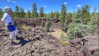
- Big Skylight Cave Sight
- Bandera Volcano Ice Cave Sight
- Mount Taylor Summit
- Coal Mine Camp Ground Camping
- Mount Sedgwick - 9249ft Summit
- Mount Taylor (11,302 ft)
- Cerro Pelon (10,026 ft)
- Cerro Osha (9,672 ft)
- By todd
 Trailforks & contributors
 - Admins: Cibola
- #36112 - 2,729 views
- grants activity log | embed map of Grants mountain bike trails | grants mountain biking points of interest
Downloading of trail gps tracks in kml & gpx formats is enabled for Grants.
You must login to download files.