close
-
Layers w
- Weather Layers
- Pro
- Pro
- Pro
- Pro
- Pro
- Pro
- More Layers
- Pro
- Pro
- Pro
- Pro
-
Upgrade to

3D
Trail Conditions
- Unknown
- Snow Groomed
- Snow Packed
- Snow Covered
- Snow Cover Partial
- Freeze/thaw Cycle
- Icy
- Prevalent Mud
- Wet
- Variable
- Ideal
- Dry
- Very Dry
Trail Flow (Ridden Direction)
Trailforks scans users ridelogs to determine the most popular direction each trail is ridden. A good flowing trail network will have most trails flowing in a single direction according to their intension.
The colour categories are based on what percentage of riders are riding a trail in its intended direction.
The colour categories are based on what percentage of riders are riding a trail in its intended direction.
- > 96%
- > 90%
- > 80%
- > 70%
- > 50%
- < 50%
- bi-directional trail
- no data
Trail Last Ridden
Trailforks scans ridelogs to determine the last time a trail was ridden.
- < 2 days
- < 1 week
- < 2 weeks
- < 1 month
- < 6 months
- > 6 months
Trail Ridden Direction
The intended direction a trail should be ridden.
- Downhill Only
- Downhill Primary
- Both Directions
- Uphill Primary
- Uphill Only
- One Direction
Contribute Details
Colors indicate trail is missing specified detail.
- Description
- Photos
- Description & Photos
- Videos
Trail Popularity ?
Trailforks scans ridelogs to determine which trails are ridden the most in the last 9 months.
Trails are compared with nearby trails in the same city region with a possible 25 colour shades.
Think of this as a heatmap, more rides = more kinetic energy = warmer colors.
- most popular
- popular
- less popular
- not popular
ATV/ORV/OHV Filter
Max Vehicle Width
inches
US Cell Coverage
Legend

Radar Time
Activity Recordings
Trailforks uses anonymized public activity data.
?
Activity Recordings
Trailforks uses anonymized public activity data.
?
Personal Heatmap
▶
Activity Types
all
/
none
▶
Options
2
Date range
month
–
Winter Trails
Warning
A routing network for winter maps does not exist. Selecting trails using the winter trails layer has been disabled.
Missing Trails
Most Popular
Least Popular
Trails are colored based on popularity. The more popular a trail is, the more red. Less popular trails trend towards green.
Jump Magnitude Heatmap
Heatmap of where riders jump on trails. Zoom in to see individual jumps, click circles to view jump details.
BC Backroad Status
![map legend]()
Service Road Atlas is a free to use, community-driven service for viewing and creating reports on the numerous back-country service roads around B.C. and Alberta.

Slope Aspect
Direction the slope faces
Trails Deemphasized
Trails are shown in grey.
Only show trails with no bike usage.
Suggested Layers
Based on selected activity type
Save the current map location and zoom level as your default home location whenever this page is loaded.
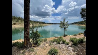
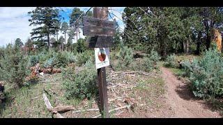
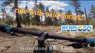
Save18 miles of flowy, singletrack goodness located in Ruidoso proper.
Primary Trail Type: All-Mountain & Downhill
AKA: Grindstone Lake
 google parking directions
 Activities Click to view
- Mountain Bike
16 trails
- Hike
17 trails
- Trail Running
17 trails
Region Details
- 5
- 2
- 9
Region Status
Caution as of May 24, 2026Local Trail Association
Stats
- Avg Trail Rating
- Trails (view details)
- 15
- Trails Mountain Bike
- 16
- Trails Hike
- 17
- Trails Trail Running
- 17
- Total Distance
- 22 miles
- Total Descent
- 4,212 ft
- Total Vertical
- 1,136 ft
- Highest Trailhead
- 7,903 ft
- Reports
- 65
- Photos
- 43
- Ridden Counter
- 1,777
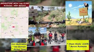
Popular Grindstone Mountain Biking Trails
• 90 ★ 4.7 • 1 mile • 73 ft • 285 •
Popular blue difficulty singletrack. This mountain bike primary trail can be used uphill primary and has a moderate overall physical rating. On average it takes 10 minutes to complete this trail.
• 100 ★ 5.0 • 4,487 ft • 295 ft • 283 •
Popular blue difficulty singletrack. This mountain bike primary trail can be used downhill primary. On average it takes 15 minutes to complete this trail.
• 100 ★ 4.5 • 3 miles • 194 ft • 262 •
Challenging climb, Techy fast downhill.
• 70 ★ 4.4 • 2 miles • 183 ft • 210 •
One of the highlights of this trail system. Fast descent, wide open turns, rock gardens and small ledges reward the rider after the long climb to the top.
• 95 ★ 5.0 • 1 mile • 219 ft • 165 •
Popular blue difficulty singletrack. This mountain bike primary trail can be used both directions. On average it takes 11 minutes to complete this trail.
• 95 ★ 4.5 • 2 miles • 693 ft • 141 •
Popular blue difficulty singletrack. This mountain bike primary trail can be used downhill primary. On average it takes 33 minutes to complete this trail.
• 65 ★ 3.5 • 3,245 ft • 102 ft • 78 •
Moderately popular green difficulty singletrack. This mountain bike primary trail can be used both directions and has a moderate overall physical rating with a 102 ft green climb. On average it takes 6 minutes to complete this trail.
Grindstone Mountain Bike Routes
15 miles • 1,869 ft • 8 • Loop •
With trails winding through pine forests and the clear waters of Grindstone Lake, Ruidoso, often described...
• 11 miles • 1,870 ft • 4 •
• 6 miles • 1,210 ft • 4 •
• 11 miles • 1,968 ft • 4 •
• 14 miles • 2,654 ft • 7 •
• 15 miles • 2,890 ft • 8 •
Photos of Grindstone Mountain Bike
Videos of Grindstone Mountain Bike

trail: Grindstone Ridge
11:52 |
47 |
Aug 25, 2025 , Ruidoso

trail: Grindstone Ridge
11:52 |
91 |
Jul 7, 2024 , Ruidoso
trail: Grindstone Ridge
9:29 |
302 |
Aug 20, 2021 , Ruidoso
trail: Grindstone Ridge
9:30 |
252 |
Aug 20, 2021 , Ruidoso
trail: Grindstone Ridge
10:49 |
290 |
Aug 20, 2021 , Ruidoso

trail: Fire Road Connector
14:42 |
244 |
Jul 15, 2021 , Ruidoso
trail: Grindstone Ridge
14:42 |
245 |
Jul 15, 2021 , Ruidoso

trail: Mesa Loop
14:42 |
364 |
Jul 15, 2021 , Ruidoso
Recent Trail Reports
| status | trail | date | condition | info | user |
|---|---|---|---|---|---|
| Lake Loop | May 24, 2026 @ 8:20am (America/Denver) May 24, 2026 | Variable | Dr-AlexHarrison | ||
| Lake Trail C | Apr 4, 2026 @ 2:35pm (America/Denver) Apr 4, 2026 | Ideal | nickyspitz | ||
| Alfred Hale Connector | Apr 4, 2026 @ 2:35pm (America/Denver) Apr 4, 2026 | Ideal | nickyspitz | ||
| Lake Trail A | Apr 4, 2026 @ 2:35pm (America/Denver) Apr 4, 2026 | Ideal | nickyspitz | ||
| North Grindstone Connector | Oct 8, 2025 @ 12:53pm (America/Denver) Oct 8, 2025 | Ideal | Jbware | ||
| Lake Trail B | Oct 8, 2025 @ 12:53pm (America/Denver) Oct 8, 2025 | Ideal | Jbware | ||
| North Grindstone Connector | Aug 11, 2023 @ 11:47am Aug 11, 2023 | Dry | FattieMcFat MFBS | ||
| Grindstone Ridge | May 22, 2021 @ 9:50am May 22, 2021 | Ideal | larrymtb | ||
| Fisherman's Trail | May 22, 2021 @ 9:50am May 22, 2021 | Dry | larrymtb |
Activity Feed
| username | action | type | title | date |
|---|---|---|---|---|
| cjRz2b | wishlist | region | activity #97392681 | Jun 20, 2026 @ 7:27am Jun 20, 2026 |
| KellyaFoRL4 | ridden | trail | activity #96600853 and 1 more | Jun 9, 2026 @ 6:15am Jun 9, 2026 |
| m0fHC3 | wishlist | trail | activity #96344152 | Jun 5, 2026 @ 11:13pm Jun 5, 2026 |
| Dr-AlexHarrison | add | report | activity #95407338 | May 24, 2026 @ 7:25am May 24, 2026 |
| Dr-AlexHarrison | ridden | trail | activity #95406912 | May 24, 2026 @ 7:19am May 24, 2026 |
Recent Comments
| username | type | title | comment | date |
|---|---|---|---|---|
| trail | Overall not bad. Tree down at mile 2.5, and... | Jul 19, 2025 @ 11:09am Jul 19, 2025 | ||
| trail | Top section pretty rough. Lotta trees down. | Jun 8, 2023 @ 12:20pm Jun 8, 2023 | ||
| trail | Best trail here!! Super fun!! | Sep 26, 2022 @ 5:41pm Sep 26, 2022 | ||
| trail | Love this entire trail system! Alfred Hale is... | Sep 26, 2022 @ 5:41pm Sep 26, 2022 | ||
| trail | Dry and only one tree across the route | May 22, 2021 @ 12:10pm May 22, 2021 |
Nearby Areas
| name | distance | ||||
|---|---|---|---|---|---|
| Cedar Creek Recreation Area | 4 | 7 | 8 | 3.3 km | |
| Alto Reservoir | 1 | 1 | 5.5 km | ||
| Apache Ski Resort | 1 | 3 | 1 | 7.3 km | |
| Fort Stanton Snowy River National Conservation Area | 2 | 1 | 16.3 km | ||
| Grandview Trails | 4 | 26.6 km |
Activity Type Stats
| activitytype | trails | distance | descent | descent distance | total vertical | rating | global rank | state rank | photos | reports | routes | ridelogs |
|---|---|---|---|---|---|---|---|---|---|---|---|---|
| Mountain Bike | 16 | 22 miles | 4,213 ft | 10 miles | 1,135 ft | #4,347 | #1,533 | 43 | 65 | 1 | 831 | |
| Hike | 17 | 22 miles | 4,213 ft | 10 miles | 1,135 ft | #8,105 | #3,007 | 65 | 81 | |||
| Trail Running | 17 | 22 miles | 4,213 ft | 10 miles | 1,135 ft | #7,744 | 65 | 62 |
Frequently Asked Questions About Grindstone
▼
What are the highest rated mountain biking trails in Grindstone?
The highest rated mountain biking trails in Grindstone are:
- Mesa Loop (4.2/5)
- Lake Trail A (4.2/5)
- North Grindstone Connector (4.1/5)
- Lake Trail C (4.1/5)
- North Grindstone Connector (4.1/5)
▼
What is the best time of the year to ride in Grindstone?
Based on ride log data, the most popular months to ride in Grindstone are:
- July (23 activities)
- October (23 activities)
- September (20 activities)
▼
Where can I park to ride in Grindstone?
▼
What is the longest trail in Grindstone?
The longest trail in Grindstone is Mesa Loop at 3.3 miles. View all trails sorted by distance.
- By BicycleRuidoso BicycleRuidoso & contributors
- Admins: BicycleRuidoso
- #8060 - 5,588 views
- grindstone activity log | embed map of Grindstone mountain bike trails | grindstone mountain biking points of interest
Downloading of trail gps tracks in kml & gpx formats is enabled for Grindstone.
You must login to download files.