close
-
Layers w
- Weather Layers
- Pro
- Pro
- Pro
- Pro
- Pro
- Pro
- More Layers
- Pro
- Pro
- Pro
- Pro
-
Upgrade to

3D
Trail Conditions
- Unknown
- Snow Groomed
- Snow Packed
- Snow Covered
- Snow Cover Partial
- Freeze/thaw Cycle
- Icy
- Prevalent Mud
- Wet
- Variable
- Ideal
- Dry
- Very Dry
Trail Flow (Ridden Direction)
Trailforks scans users ridelogs to determine the most popular direction each trail is ridden. A good flowing trail network will have most trails flowing in a single direction according to their intension.
The colour categories are based on what percentage of riders are riding a trail in its intended direction.
The colour categories are based on what percentage of riders are riding a trail in its intended direction.
- > 96%
- > 90%
- > 80%
- > 70%
- > 50%
- < 50%
- bi-directional trail
- no data
Trail Last Ridden
Trailforks scans ridelogs to determine the last time a trail was ridden.
- < 2 days
- < 1 week
- < 2 weeks
- < 1 month
- < 6 months
- > 6 months
Trail Ridden Direction
The intended direction a trail should be ridden.
- Downhill Only
- Downhill Primary
- Both Directions
- Uphill Primary
- Uphill Only
- One Direction
Contribute Details
Colors indicate trail is missing specified detail.
- Description
- Photos
- Description & Photos
- Videos
Trail Popularity ?
Trailforks scans ridelogs to determine which trails are ridden the most in the last 9 months.
Trails are compared with nearby trails in the same city region with a possible 25 colour shades.
Think of this as a heatmap, more rides = more kinetic energy = warmer colors.
- most popular
- popular
- less popular
- not popular
ATV/ORV/OHV Filter
Max Vehicle Width
inches
US Cell Coverage
Legend

Radar Time
Activity Recordings
Trailforks uses anonymized public activity data.
?
Activity Recordings
Trailforks uses anonymized public activity data.
?
Personal Heatmap
▶
Activity Types
all
/
none
▶
Options
2
Date range
month
–
Winter Trails
Warning
A routing network for winter maps does not exist. Selecting trails using the winter trails layer has been disabled.
Missing Trails
Most Popular
Least Popular
Trails are colored based on popularity. The more popular a trail is, the more red. Less popular trails trend towards green.
Jump Magnitude Heatmap
Heatmap of where riders jump on trails. Zoom in to see individual jumps, click circles to view jump details.
BC Backroad Status
![map legend]()
Service Road Atlas is a free to use, community-driven service for viewing and creating reports on the numerous back-country service roads around B.C. and Alberta.

Slope Aspect
Direction the slope faces
Trails Deemphasized
Trails are shown in grey.
Only show trails with no bike usage.
Suggested Layers
Based on selected activity type
Save the current map location and zoom level as your default home location whenever this page is loaded.
SaveThe Mountain Bike scene in India related to Downhill is still Developing
Region Details
- 3
- 6
- 51
- 35
- 21
- 2
Stats
- Avg Trail Rating
- Trails (view details)
- 119
- Trails Mountain Bike
- 123
- Trails E-Bike
- 42
- Trails Horse
- 2
- Trails Hike
- 97
- Trails Trail Running
- 101
- Trails Dirtbike/Moto
- 6
- Total Distance
- 164 miles
- Total Descent
- 32,646 ft
- Total Vertical
- 13,053 ft
- Highest Trailhead
- 13,054 ft
- Reports
- 187
- Photos
- 334
- Ridden Counter
- 235
Articles
Details Announced for Zabarvan Legends 2025, India’s First Downhill MTB Series
Nov 6, 2025 from pinkbike.com
India has officially arrived on the world’s downhill mountain biking radar.
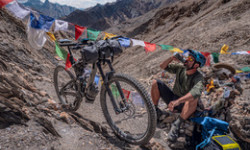
Photo Story: Exploring Ladakh In High Altitude Roaming
Mar 25, 2023 from pinkbike.com
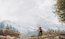
Cedric takes off exploring the Himalayan region on a bike at dizzying altitudes.

Video: Riding The Untouched Terrain & Unridden Lines of Ladakh, India in 'Dirt Nuggets'
Feb 21, 2023 from pinkbike.com
Six mountain bikers tread the untouched terrain of Ladakh for inaugural descents and undiscovered trails.

Report: Ladakh MTB Festival Celebrates the Opening of the Disko Valley Bike Park
Oct 15, 2019 from pinkbike.com
Mountain biking gets a home in the Lower Himayalan territory of Ladakh in northern India.
Popular Trail Networks
view all areas »Sub Regions
- Andaman and Nicobar Islands (0)
- Andhra Pradesh (3)
- Arunachal Pradesh (0)
- Assam (0)
- Bihar (0)
- Chandigarh (0)
- Chhattisgarh (0)
- Dadra and Nagar Haveli (0)
- Daman and Diu (0)
- Goa (0)
- Gujarat (0)
- Haryana (6)
- Himachal Pradesh (2)
- Manali (2)
- Manali (2)
- Jammu and Kashmir (2)
- Srinagar (2)
- Srinagar (2)
- Jharkhand (33)
- Jamshedpur (33)
- Jamshedpur (33)
- Karnataka (4)
- Bangalore (4)
- Bangalore (4)
- Kerala (0)
- Lakshadweep (0)
- Maharashtra (15)
- Pune (15)
- Pune (15)
- Manipur (0)
- Nagaland (7)
- Kohima (7)
- Kohima (7)
- National Capital Territory of Delhi (0)
- Odisha (0)
- Puducherry (0)
- Punjab (0)
- Sikkim (0)
- Tamil Nadu (0)
- Telangana (27)
- Hyderabad (27)
- Hyderabad (27)
- Uttar Pradesh (0)
- Uttarakhand (0)
- West Bengal (10)
- Darjeeling (3)
- kolkata (4)
- Purulia (3)
- Darjeeling (3)
- Leh (1)
Popular India Mountain Biking Trails
• 100 ★ 0.0 • 3,889 ft • 40 ft • 7 •
Undulating singletrack with loose pebbles, baby heads, rock gardens, and leaves in the winter.
• 5 ★ 3.0 • 2 miles • 52 ft • 4 •
One of the easiest trails in the city, a long twisting trail with loads of open space around to stop and take in the views. It is highly recommended to stop and let it all sink in. I wouldn't miss it for the world!
• 5 ★ 5.0 • 7 miles • 440 ft • 4 •
Less popular green difficulty family friendly singletrack. This mountain bike primary trail can be used both directions and has a moderate overall physical rating with a 440 ft blue climb. Trail visibility is always easy to follow. On average it takes 1 hour19 minutes to complete this trail.
• 5 ★ 4.0 • 1,207 ft • 18 ft • 3 •
The entry to the Aga khan trail system. An easy and mellow trail that leads into a tighter, more difficult trail (snake Trail).
• 5 ★ 5.0 • 2,198 ft • 113 ft • 3 •
Less popular blue difficulty singletrack. This mountain bike primary trail can be used both directions and has a moderate overall physical rating with a 113 ft blue climb. Trail visibility is always easy to follow. On average it takes 53 minutes to complete this trail.
• 5 ★ 0.0 • 2,917 ft • 0 ft • 3 •
It's an All-in-One! From straight-line flow to technical corners and even a few jumps! A beginner trail meant to teach you the basics of mountain biking and its beauty!
India Mountain Bike Routes
Beat Around The Bush Featured
★ 5.0 • 30 miles • 694 ft • 2 • Loop •
Ever Wondered if you could add a few more Kms to without having to deal with the troubles of traffic and...
Along A Rail Line Featured
★ 4.0 • 19 miles • 551 ft • 0 • Loop •
A beautiful scenic gravel and dust adventure through the hidden roads of a concrete jungle. The objective...
32 miles • 7,715 ft • 0 •
37 miles • 1,359 ft • 0 •
59 miles • 1,800 ft • 0 • Loop •
.............................................................
Photos of India Mountain Bike
Videos of India Mountain Bike
trail: Plunge
0:29 |
64 |
Dec 28, 2022
trail: Sinker
0:10 |
85 |
Mar 9, 2022
trail: Sinker
0:00 |
96 |
Jul 7, 2021
trail: Sinker
0:13 |
100 |
Apr 16, 2021
trail: Sinker
0:11 |
57 |
Apr 16, 2021
trail: Sinker
0:58 |
44 |
Mar 16, 2021

trail: Pardih DH trail
4:45 |
27 |
Nov 28, 2020
trail: Elevated Shreducation
0:26 |
94 |
Sep 10, 2020
Recent Comments
| username | type | title | comment | date |
|---|---|---|---|---|
| trail | Excellent trail to ride country side. | Sep 26, 2021 @ 5:02am Sep 26, 2021 | ||
| trail | Great job | Oct 25, 2020 @ 10:09am Oct 25, 2020 | ||
| skillpark | superb park..... 3 it | Apr 26, 2015 @ 8:39am Apr 26, 2015 |
Bike & Skill Parks
| name | type | city | rating |
|---|---|---|---|
| Hercules Mountain Bike Park | skill park | OOTY | |
| WallRide Park Hyderabad | skill park | Hyderabad | |
| Pedalers Village | skill park | Gurgaon | |
| Avanti Bikepark | skill park | Pune |
Activity Type Stats
| activitytype | trails | distance | descent | descent distance | total vertical | rating | global rank | state rank | photos | reports | routes | ridelogs |
|---|---|---|---|---|---|---|---|---|---|---|---|---|
| Mountain Bike | 119 | 162 miles | 32,641 ft | 76 miles | 13,054 ft | #71 | 334 | 190 | 9 | 8,514 | ||
| E-Bike | 42 | 58 miles | 7,549 ft | 25 miles | 5,489 ft | #74 | 107 | 3 | 56 | |||
| Horse | 2 | 9 miles | 266 ft | 4 miles | 512 ft | #67 | 18 | |||||
| Hike | 97 | 127 miles | 30,640 ft | 60 miles | 13,054 ft | #76 | 117 | 1,943 | ||||
| Trail Running | 101 | 151 miles | 31,407 ft | 69 miles | 13,054 ft | #73 | 110 | 210 | ||||
| Dirtbike/Moto | 6 | 14 miles | 1,024 ft | 5 miles | 928 ft | #58 | 22 | 11 |
Activities
Trails
- By canadaka
 Trailforks & contributors
 - Admins: apply
- #3226 - 45,564 views
- india activity log | embed map of India mountain bike trails | india mountain biking points of interest
Downloading of trail gps tracks in kml & gpx formats is enabled for India.
You must login to download files.