close
-
Layers w
- Weather Layers
- Pro
- Pro
- Pro
- Pro
- Pro
- Pro
- More Layers
- Pro
- Pro
- Pro
- Pro
-
Upgrade to

3D
Trail Conditions
- Unknown
- Snow Groomed
- Snow Packed
- Snow Covered
- Snow Cover Partial
- Freeze/thaw Cycle
- Icy
- Prevalent Mud
- Wet
- Variable
- Ideal
- Dry
- Very Dry
Trail Flow (Ridden Direction)
Trailforks scans users ridelogs to determine the most popular direction each trail is ridden. A good flowing trail network will have most trails flowing in a single direction according to their intension.
The colour categories are based on what percentage of riders are riding a trail in its intended direction.
The colour categories are based on what percentage of riders are riding a trail in its intended direction.
- > 96%
- > 90%
- > 80%
- > 70%
- > 50%
- < 50%
- bi-directional trail
- no data
Trail Last Ridden
Trailforks scans ridelogs to determine the last time a trail was ridden.
- < 2 days
- < 1 week
- < 2 weeks
- < 1 month
- < 6 months
- > 6 months
Trail Ridden Direction
The intended direction a trail should be ridden.
- Downhill Only
- Downhill Primary
- Both Directions
- Uphill Primary
- Uphill Only
- One Direction
Contribute Details
Colors indicate trail is missing specified detail.
- Description
- Photos
- Description & Photos
- Videos
Trail Popularity ?
Trailforks scans ridelogs to determine which trails are ridden the most in the last 9 months.
Trails are compared with nearby trails in the same city region with a possible 25 colour shades.
Think of this as a heatmap, more rides = more kinetic energy = warmer colors.
- most popular
- popular
- less popular
- not popular
ATV/ORV/OHV Filter
Max Vehicle Width
inches
US Cell Coverage
Legend

Radar Time
Activity Recordings
Trailforks uses anonymized public activity data.
?
Activity Recordings
Trailforks uses anonymized public activity data.
?
Personal Heatmap
▶
Activity Types
all
/
none
▶
Options
2
Date range
month
–
Winter Trails
Warning
A routing network for winter maps does not exist. Selecting trails using the winter trails layer has been disabled.
Missing Trails
Most Popular
Least Popular
Trails are colored based on popularity. The more popular a trail is, the more red. Less popular trails trend towards green.
Jump Magnitude Heatmap
Heatmap of where riders jump on trails. Zoom in to see individual jumps, click circles to view jump details.
BC Backroad Status
![map legend]()
Service Road Atlas is a free to use, community-driven service for viewing and creating reports on the numerous back-country service roads around B.C. and Alberta.

Slope Aspect
Direction the slope faces
Trails Deemphasized
Trails are shown in grey.
Only show trails with no bike usage.
Suggested Layers
Based on selected activity type
Save the current map location and zoom level as your default home location whenever this page is loaded.
SaveThis region is Unsanctioned, Ride at your own Risk!
Trails for everyone.
There are easy, flowing Trails around but there are also gnarly technical descends.
The Trails are best linked by Forest roads and doubletracks.
Please pay attention to Hikers and be respectful to everyone in the forest. Enter and exit trails with caution.
There are easy, flowing Trails around but there are also gnarly technical descends.
The Trails are best linked by Forest roads and doubletracks.
Please pay attention to Hikers and be respectful to everyone in the forest. Enter and exit trails with caution.
This region uses the Uk/Euro style trail grading system.
Activities Click to view
- Mountain Bike
25 trails
- E-Bike
26 trails
- Adaptive Bike
0 trails
- Winter Fat Bike
0 trails
- Hike
19 trails
- Trail Running
19 trails
Region Details
- 10
- 12
- 4
Region Status
Caution as of Dec 10, 2025Stats
- Avg Trail Rating
- Trails (view details)
- 25
- Trails Mountain Bike
- 26
- Trails E-Bike
- 26
- Trails Hike
- 19
- Trails Trail Running
- 19
- Total Distance
- 12 miles
- Total Descent
- 5,625 ft
- Total Vertical
- 1,069 ft
- Highest Trailhead
- 1,599 ft
- Reports
- 204
- Photos
- 65
- Ridden Counter
- 1,085
Sub Regions
-
Eisenwald
- 2
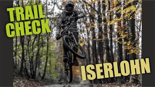
Popular Iserlohn Mountain Biking Trails
• 80 ★ 4.5 • 1 mile • 60 ft • 116 •
Really Awesome trail, Jumps, Roots, Berms, Drops, everything you could ask for. A bit of pedaling along the ridge at the top (awesome at sunset), afterwards fast flowing jumps/step downs/drops and a bit of technical endurostyle single...
• 90 ★ 4.7 • 2,556 ft • 10 ft • 81 •
Fun and diversified trail, sharp turns at the top, fast section with lots of roots in the lower bit.
• 5 ★ 4.0 • 799 ft • 11 ft • 46 •
flowing technical trail with corners to pop and slippery off cambers and of course through a river towards the end :-)
• 95 ★ 2.5 • 3,176 ft • 0 ft • 29 •
Popular green difficulty singletrack. This mountain bike primary trail can be used downhill primary and has a easy overall physical rating with a 0 ft green climb. Trail visibility is always easy to follow. On average it takes 4 minutes to complete this trail.
• 55 ★ 5.0 • 2,283 ft • 15 ft • 28 •
Moderately popular blue difficulty singletrack. This mountain bike primary trail can be used downhill only and has a easy overall physical rating. On average it takes 8 minutes to complete this trail.
• 60 ★ 4.4 • 1,732 ft • 0 ft • 28 •
Great Alpine-like Trail. Loads and loads of rocks and technical turns. Ride with big caution, because there is a cliff to the left hand side.
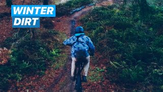
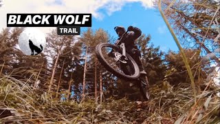
Iserlohn Mountain Bike Routes
Photos of Iserlohn Mountain Bike
Videos of Iserlohn Mountain Bike

trail: Home Sweet Home
3:55 |
5662 |
May 15, 2018

trail: Home Sweet Home
0:23 |
216 |
Aug 2, 2010
5:15 |
1097 |
Dec 30, 2019 , Iserlohn

5:22 |
337 |
Dec 16, 2019 , Iserlohn
trail: Step Down
5:22 |
293 |
Dec 16, 2019 , Iserlohn

trail: Tranny
4:56 |
815 |
Sep 29, 2019 , Iserlohn
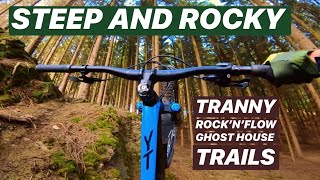
trail: Ghost House Trail
4:56 |
605 |
Sep 29, 2019 , Iserlohn
trail: Geilomaten Trail
3:46 |
459 |
Sep 28, 2019 , Iserlohn
Recent Trail Reports
| status | trail | date | condition | info | user |
|---|---|---|---|---|---|
| Trail Grünequelle West | Dec 10, 2025 @ 4:22pm (Europe/Luxembourg) Dec 10, 2025 | Wet | deba | ||
| Hilborn DH aka. Roller Coaster | May 1, 2025 @ 2:35am May 1, 2025 | Ideal | Herr87MP62 | ||
| Flugbahn | Apr 27, 2025 @ 11:45am Apr 27, 2025 | Very Dry | deba | ||
| Umweg | Apr 27, 2025 @ 11:45am Apr 27, 2025 | Ideal | deba | ||
| Drahtrolle | Apr 12, 2025 @ 11:54am Apr 12, 2025 | Very Dry | Kanonental | ||
| Schmelzbahn | Apr 12, 2025 @ 11:54am Apr 12, 2025 | Very Dry | Kanonental | ||
| Rock ´n´ Flow VOL. II | Apr 9, 2025 @ 4:15pm Apr 9, 2025 | Very Dry | Kanonental | ||
| Alpenfieber | Apr 4, 2025 @ 5:18pm Apr 4, 2025 | Dry | Benjaminn8l5dY | ||
| Step Down | Jul 2, 2024 @ 2:00pm Jul 2, 2024 | Wet | heitride | ||
| Bismarckturm Ost | Jun 29, 2024 @ 2:12am Jun 29, 2024 | Variable | Wolfsblut |
Activity Feed
| username | action | type | title | date |
|---|---|---|---|---|
| SteveAzcJ90 | ridden | trail | activity #96240484 and 3 more | Jun 4, 2026 @ 11:05am 1 mins |
| Flaco500 | wishlist | trail | activity #92850168 | Apr 18, 2026 @ 5:27am Apr 18, 2026 |
| AndrejmMF3X | comment | trail | activity #92540726 | Apr 13, 2026 @ 8:43am Apr 13, 2026 |
| zPgiOa | wishlist | trail | activity #90689496 and 1 more | Mar 16, 2026 @ 7:23am Mar 16, 2026 |
| aiS1LA | wishlist | trail | activity #87912596 and 5 more | Jan 27, 2026 @ 2:48pm Jan 27, 2026 |
Recent Comments
| username | type | title | comment | date |
|---|---|---|---|---|
| trail | Oberer Teil komplett von Harvestern zerstört.... | Apr 13, 2026 @ 8:43am Apr 13, 2026 | ||
| trail | Trail ist toll, aber nicht für den... | Sep 1, 2025 @ 9:22am Sep 1, 2025 | ||
| trail | Der obere Teil (ca. 400m) bis kurz vor dem... | Jun 14, 2025 @ 4:16am Jun 14, 2025 | ||
| trail | Top Zustand und macht echt Bock! | May 1, 2025 @ 2:34am May 1, 2025 | ||
| report | Gute Frage, meine ja nur dass er nicht nach... | Mar 2, 2025 @ 7:39am Mar 2, 2025 |
Local Badges
-

Epic Ride Climb 2k18 awarded -

Climbing 10k Badge15 awarded -

Climbing 100k Badge1 awarded -

Epic Ride Descent 2k18 awarded -

Descent 10k Badge15 awarded -

Descent 100k Badge1 awarded
Activity Type Stats
| activitytype | trails | distance | descent | descent distance | total vertical | rating | global rank | state rank | photos | reports | routes | ridelogs |
|---|---|---|---|---|---|---|---|---|---|---|---|---|
| Mountain Bike | 25 | 12 miles | 5,623 ft | 8 miles | 1,070 ft | #4,009 | #64 | 64 | 204 | 2 | 2,612 | |
| E-Bike | 26 | 12 miles | 5,623 ft | 8 miles | 1,070 ft | #3,381 | #78 | 1 | 149 | 582 | ||
| Hike | 19 | 9 miles | 3,802 ft | 6 miles | 1,070 ft | #5,954 | 185 | 65 | ||||
| Trail Running | 19 | 9 miles | 3,802 ft | 6 miles | 1,070 ft | #5,399 | #65 | 185 | 60 |
Frequently Asked Questions About Iserlohn
▼
What are the best places to ride in Iserlohn?
Iserlohn has 1 areas to explore for mountain biking. The top rated areas are:
▼
What are the highest rated mountain biking trails in Iserlohn?
The highest rated mountain biking trails in Iserlohn are:
- Hilborn DH aka. Roller Coaster (4.3/5)
- Step Down (4.3/5)
- Alpenfieber (4.2/5)
- Hummelbiene (4.1/5)
- Kobold (4.1/5)
▼
What is the best time of the year to ride in Iserlohn?
Based on ride log data, the most popular months to ride in Iserlohn are:
- July (20 activities)
- August (17 activities)
- June (15 activities)
▼
Where can I park to ride in Iserlohn?
There are 1 parking locations listed in Iserlohn. The most popular parking spots are:
Activities
Trails
Points of Interest
- By pleaseenternamehere
 TRAILFORKS & contributors
 - Admins: pleaseenternamehere
- #22122 - 9,285 views
- iserlohn activity log | embed map of Iserlohn mountain bike trails | iserlohn mountain biking points of interest
Downloading of trail gps tracks in kml & gpx formats is enabled for Iserlohn.
You must login to download files.