close
-
Layers w
- Map Content
- More Layers
- Pro
- Pro
- Pro
- Pro
- Pro
- Pro
- Pro
- Pro
-
Upgrade to

3D
Trail Conditions
- Unknown
- Snow Groomed
- Snow Packed
- Snow Covered
- Snow Cover Partial
- Freeze/thaw Cycle
- Icy
- Prevalent Mud
- Wet
- Variable
- Ideal
- Dry
- Very Dry
Trail Flow (Ridden Direction)
Trailforks scans users ridelogs to determine the most popular direction each trail is ridden. A good flowing trail network will have most trails flowing in a single direction according to their intension.
The colour categories are based on what percentage of riders are riding a trail in its intended direction.
The colour categories are based on what percentage of riders are riding a trail in its intended direction.
- > 96%
- > 90%
- > 80%
- > 70%
- > 50%
- < 50%
- bi-directional trail
- no data
Trail Last Ridden
Trailforks scans ridelogs to determine the last time a trail was ridden.
- < 2 days
- < 1 week
- < 2 weeks
- < 1 month
- < 6 months
- > 6 months
Trail Ridden Direction
The intended direction a trail should be ridden.
- Downhill Only
- Downhill Primary
- Both Directions
- Uphill Primary
- Uphill Only
- One Direction
Contribute Details
Colors indicate trail is missing specified detail.
- Description
- Photos
- Description & Photos
- Videos
Trail Popularity ?
Trailforks scans ridelogs to determine which trails are ridden the most in the last 9 months.
Trails are compared with nearby trails in the same city region with a possible 25 colour shades.
Think of this as a heatmap, more rides = more kinetic energy = warmer colors.
- most popular
- popular
- less popular
- not popular
ATV/ORV/OHV Filter
Max Vehicle Width
inches
US Cell Coverage
Legend

Radar Time
x
Activity Recordings
Trailforks users anonymized public ridelogs from the past 6 months.
- mountain biking recent
- mountain biking (>6 month)
- hiking (1 year)
- moto (1 year)
Activity Recordings
Trailforks users anonymized public skilogs from the past 12 months.
- Downhill Ski
- Backcountry Ski
- Nordic Ski
- Snowmobile
Winter Trails
Warning
A routing network for winter maps does not exist. Selecting trails using the winter trails layer has been disabled.
x
Missing Trails
Most Popular
Least Popular
Trails are colored based on popularity. The more popular a trail is, the more red. Less popular trails trend towards green.
Jump Magnitude Heatmap
Heatmap of where riders jump on trails. Zoom in to see individual jumps, click circles to view jump details.
Trails Deemphasized
Trails are shown in grey.
Only show trails with NO bikes.
Save the current map location and zoom level as your default home location whenever this page is loaded.
Save
No description for Landkreis Aschaffenburg has been added yet!
Login or register to submit one.
This region uses the Uk/Euro style trail grading system.
Activities Click to view
- Mountain Bike
18 trails
- E-Bike
18 trails
- Hike
3 trails
- Trail Running
3 trails
Region Details
- 7
- 7
- 4
Stats
- Avg Trail Rating
- Trails (view details)
- 18
- Trails Mountain Bike
- 18
- Trails E-Bike
- 18
- Trails Hike
- 3
- Trails Trail Running
- 3
- Total Distance
- 14 miles
- Total Descent
- 6,167 ft
- Total Vertical
- 1,127 ft
- Highest Trailhead
- 1,701 ft
- Reports
- 113
- Photos
- 12
- Ridden Counter
- 686
Sub Regions
- Alzenau (7)
- Kammtrails (6)
- Heimbuchenthal (4)
- Heinrichsthal (2)
Popular Landkreis Aschaffenburg Mountain Biking Trails
| status | title | difficulty | rating |
|---|---|---|---|
| Burgen-Trail Kammtrails | |||
| Speichenbachtrail Kammtrails | |||
| Brandfleck Trail Kammtrails | |||
| Giftiger Berg Trail Kammtrails | |||
| Hexen Thorn Trail Kammtrails | |||
| Domina Trail Kammtrails | |||
| Eselsweg-Trail Heinrichsthal | |||
| Hirsch-Trail Landkreis Aschaffenburg | |||
| Waldsee-Trail Landkreis Aschaffenburg | |||
| Staats-Trail Landkreis Aschaffenburg | |||
| Kutscherhohle Landkreis Aschaffenburg | |||
| Fuchsbau Landkreis Aschaffenburg | |||
| Birklersgrundtrail 2 Heinrichsthal | |||
| Meiler-Trail Heimbuchenthal | |||
| Müller´s-Hecke Heimbuchenthal |
Photos of Landkreis Aschaffenburg Mountain Bike
trail: Domina Trail
28 |
May 8, 2023 @ 7:15am
May 8, 2023
trail: Speichenbachtrail
90 |
Nov 24, 2021 @ 10:32am
Nov 24, 2021
trail: Burgen-Trail
173 |
Jul 17, 2020 @ 11:14am
Jul 17, 2020
trail: Burgen-Trail
126 |
May 14, 2020 @ 6:27am
May 14, 2020
trail: Burgen-Trail
91 |
May 14, 2020 @ 6:27am
May 14, 2020
trail: Burgen-Trail
124 |
May 14, 2020 @ 6:27am
May 14, 2020
trail: Burgen-Trail
105 |
May 14, 2020 @ 6:26am
May 14, 2020Videos of Landkreis Aschaffenburg Mountain Bike
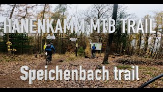
trail: Speichenbachtrail
11:02 |
358 |
Nov 24, 2021 , Alzenau
Recent Trail Reports
| status | trail | date | condition | info | user |
|---|---|---|---|---|---|
| Burgen-Trail Kammtrails | Apr 12, 2024 @ 6:09am Apr 12, 2024 | Ideal | Musashi178 | ||
| Hexen Thorn Trail Kammtrails | Mar 27, 2024 @ 5:37am Mar 27, 2024 | Unknown | JannBorlinghaus | ||
| Speichenbachtrail Kammtrails | Mar 27, 2024 @ 12:06am Mar 27, 2024 | Prevalent Mud | JannBorlinghaus | ||
| Brandfleck Trail Kammtrails | Oct 22, 2023 @ 5:44am Oct 22, 2023 | Variable | Willer82 | ||
| Domina Trail Kammtrails | Oct 9, 2023 @ 3:09am Oct 9, 2023 | Dry | vichivano | ||
| Giftiger Berg Trail Kammtrails | Oct 9, 2023 @ 3:09am Oct 9, 2023 | Dry | vichivano | ||
| Eselsweg-Trail Heinrichsthal | Mar 11, 2023 @ 7:59am Mar 11, 2023 | Prevalent Mud | Paintman | ||
| Fuchsbau Landkreis Aschaffenburg | Jul 4, 2022 @ 11:09am Jul 4, 2022 | Dry | dakannzdemasehn | ||
| Meiler-Trail Heimbuchenthal | Apr 19, 2022 @ 2:32am Apr 19, 2022 | Ideal | proneman | ||
| Müller´s-Hecke Heimbuchenthal | Apr 19, 2022 @ 2:32am Apr 19, 2022 | Ideal | proneman |
Activity Feed
| username | action | type | title | date |
|---|---|---|---|---|
| Mad-Dog22 | wishlist | trail | activity #52781397 | May 18, 2024 @ 12:50pm 1 day |
| JoachimrrjYB9 | wishlist | region | activity #52107401 | May 4, 2024 @ 9:37pm May 4, 2024 |
| Robertf3DhGx | wishlist | trail | activity #51087763 and 2 more | Apr 12, 2024 @ 1:25pm Apr 12, 2024 |
| Musashi178 | add | report | activity #51075485 | Apr 12, 2024 @ 7:38am Apr 12, 2024 |
| foksu | ridden | trail | activity #50904557 and 5 more | Apr 7, 2024 @ 12:02pm Apr 7, 2024 |
Recent Comments
| username | type | title | comment | date |
|---|---|---|---|---|
| report | Clear, Ideal to ride | Mar 27, 2024 @ 5:38am Mar 27, 2024 | ||
| trail | Oktober 2023, leider ist der gesamte Trail... | Oct 8, 2023 @ 3:42am Oct 8, 2023 | ||
| trail | Epic trail, probably the hardest one in the... | Jun 22, 2023 @ 10:46am Jun 22, 2023 | ||
| trail | Great trail, it is marked as a red on the... | Jun 22, 2023 @ 10:45am Jun 22, 2023 | ||
| trail | Very nice trail, fun turns and jumps with some... | Jun 22, 2023 @ 10:43am Jun 22, 2023 |
Activity Type Stats
| activitytype | trails | distance | descent | descent distance | total vertical | rating | global rank | state rank | photos | reports | routes | ridelogs |
|---|---|---|---|---|---|---|---|---|---|---|---|---|
| Mountain Bike | 18 | 14 miles | 6,168 ft | 12 miles | 1,125 ft | 12 | 113 | 2,942 | ||||
| E-Bike | 18 | 14 miles | 6,168 ft | 12 miles | 1,125 ft | 102 | 247 | |||||
| Hike | 3 | 3 miles | 1,207 ft | 3 miles | 1,112 ft | 91 | 71 | |||||
| Trail Running | 3 | 3 miles | 1,207 ft | 3 miles | 1,112 ft | 91 | 13 |
- By larry81541
 & contributors
 - Admins: Sasse82, elreyrules, cemoorelife, larry81541
- #41001 - 715 views
- landkreis aschaffenburg activity log | embed map of Landkreis Aschaffenburg mountain bike trails |
Downloading of trail gps tracks in kml & gpx formats is enabled for Landkreis Aschaffenburg.
You must login to download files.