close
-
Layers w
- Weather Layers
- Pro
- Pro
- Pro
- Pro
- Pro
- Pro
- More Layers
- Pro
- Pro
- Pro
- Pro
-
Upgrade to

3D
Trail Conditions
- Unknown
- Snow Groomed
- Snow Packed
- Snow Covered
- Snow Cover Partial
- Freeze/thaw Cycle
- Icy
- Prevalent Mud
- Wet
- Variable
- Ideal
- Dry
- Very Dry
Trail Flow (Ridden Direction)
Trailforks scans users activity logs to determine the most popular direction each trail is ridden. A good flowing trail network will have most trails flowing in a single direction according to their intension.
The colour categories are based on what percentage of users are riding a trail in its intended direction.
The colour categories are based on what percentage of users are riding a trail in its intended direction.
- > 96%
- > 90%
- > 80%
- > 70%
- > 50%
- < 50%
- bi-directional trail
- no data
Trail Last Ridden
Trailforks scans activity logs to determine the last time a trail was ridden.
- < 2 days
- < 1 week
- < 2 weeks
- < 1 month
- < 6 months
- > 6 months
Trail Ridden Direction
The intended direction a trail should be ridden.
- Downhill Only
- Downhill Primary
- Both Directions
- Uphill Primary
- Uphill Only
- One Direction
Contribute Details
Colors indicate trail is missing specified detail.
- Description
- Photos
- Description & Photos
- Videos
Trail Popularity ?
Trailforks scans activity logs to determine which trails are ridden the most in the last 9 months.
Trails are compared with nearby trails in the same city region with a possible 25 colour shades.
Think of this as a heatmap, more activities = more kinetic energy = warmer colors.
- most popular
- popular
- less popular
- not popular
ATV/ORV/OHV Filter
Max Vehicle Width
inches
US Cell Coverage
Legend

Radar Time
Activity Recordings
Trailforks uses anonymized public activity data.
?
Activity Recordings
Trailforks uses anonymized public activity data.
?
Personal Heatmap
▶
Activity Types
all
/
none
▶
Options
2
Date range
month
–
Winter Trails
Warning
A routing network for winter maps does not exist. Selecting trails using the winter trails layer has been disabled.
Missing Trails
Most Popular
Least Popular
Trails are colored based on popularity. The more popular a trail is, the more red. Less popular trails trend towards green.
Jump Magnitude Heatmap
Heatmap of where users jump on trails. Zoom in to see individual jumps, click circles to view jump details.
BC Backroad Status
![map legend]()
Service Road Atlas is a free to use, community-driven service for viewing and creating reports on the numerous back-country service roads around B.C. and Alberta.

Slope Aspect
Direction the slope faces
Trails Deemphasized
Trails are shown in grey.
Only show trails with no bike usage.
Suggested Layers
Based on selected activity type
Save the current map location and zoom level as your default home location whenever this page is loaded.
Save
No description for Lech has been added yet!
Login or register to submit one.
This region uses the Uk/Euro style trail grading system.
Activities Click to view
- Mountain Bike
1 trails
- Hike
2 trails
- Trail Running
2 trails
- Backcountry Ski
34 trails
Region Details
- 1
Region Status
Open as of Jun 24, 2026Stats
- Avg Trail Rating
- Trails (view details)
- 36
- Trails Mountain Bike
- 1
- Trails E-Bike
- 1
- Trails Hike
- 2
- Trails Trail Running
- 2
- Trails Backcountry Ski
- 34
- Total Distance
- 89 miles
- Total Descent Distance
- 43 miles
- Total Descent
- 45,005 ft
- Total Vertical
- 6,054 ft
- Highest Trailhead
- 9,273 ft
- Reports
- 2
- Photos
- 6
- Completed Counter
- 98
Popular Lech Mountain Biking Trails
• 100 ★ 2.0 • 2 miles • 6 ft • 24 •
Der in Lech am Arlberg ist die erste offizielle Freeride- und Endurostrecke in Vorarlberg und bietet den Gästen in der Destination Lech Zürs und Umgebung eine zusätzliche sportliche Attraktion bei der Bergbahn Oberlech und der . Der...
Videos of Lech Mountain Bike
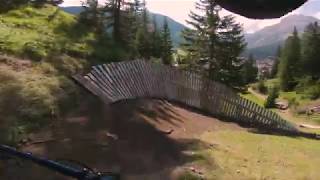
trail: Burgwald Trail
8:37 |
762 |
Apr 20, 2019 , Lech
Recent Trail Reports
| status | trail | date | condition | info | user |
|---|---|---|---|---|---|
| Burgwald Trail | Jun 24, 2026 @ 6:22pm (Europe/Vienna) Jun 24, 2026 | Dry | ocramrebiad |
Activity Feed
| username | action | type | title | date |
|---|---|---|---|---|
| ocramrebiad | add | report | activity #97703498 | Jun 24, 2026 @ 9:25am Jun 24, 2026 |
| mrallankey | ridden | trail | activity #96528746 | Jun 8, 2026 @ 3:32am Jun 8, 2026 |
| lilyDvtvh5 | wishlist | region | activity #94803430 | May 16, 2026 @ 4:57am May 16, 2026 |
| Nico9grhqN | ridden | trail | activity #58420808 | Sep 6, 2024 @ 7:44am Sep 6, 2024 |
| AdrianfRaWun | comment | trail | activity #56626475 | Aug 3, 2024 @ 6:28am Aug 3, 2024 |
Recent Comments
| username | type | title | comment | date |
|---|---|---|---|---|
| trail | Ganze Saison Hälfte des Trails gesperrt.... | Aug 3, 2024 @ 6:28am Aug 3, 2024 | ||
| report | S3 to S4 | Aug 23, 2021 @ 11:19am Aug 23, 2021 | ||
| trail | This Trail is already open since 2018 or so | Sep 22, 2019 @ 2:28am Sep 22, 2019 |
Local Badges
-

Epic Ride Descent 2k17 awarded -

Descent 10k Badge4 awarded -

Descent 100k Badge0 awarded
Activity Type Stats
| activitytype | trails | distance | descent | descent distance | total vertical | rating | global rank | state rank | photos | reports | routes | activity logs |
|---|---|---|---|---|---|---|---|---|---|---|---|---|
| Mountain Bike | 1 | 2 miles | 1,558 ft | 2 miles | 1,555 ft | #11,071 | #120 | 6 | 2 | 167 | ||
| E-Bike | 1 | 2 miles | 1,558 ft | 2 miles | 1,555 ft | 2 | 17 | |||||
| Hike | 2 | 5 miles | 4,537 ft | 4 miles | 2,907 ft | #7,123 | #90 | 2 | 195 | |||
| Trail Running | 2 | 5 miles | 4,537 ft | 4 miles | 2,907 ft | #6,658 | #86 | 2 | 9 | |||
| Backcountry Ski | 34 | 85 miles | 40,466 ft | 38 miles | 6,053 ft | #20 | #8 | 104 |
Frequently Asked Questions About Lech
▼
What are the highest rated mountain biking trails in Lech?
The highest rated mountain biking trails in Lech are:
- Burgwald Trail (3.3/5)
▼
What is the best time of the year to ride in Lech?
Based on activity log data, the most popular months to ride in Lech are:
- July (7 activities)
- September (3 activities)
- August (1 activities)
▼
Where can I park to ride in Lech?
Check the Lech trail map for trailhead and parking information. Community members regularly update access and parking details for trails in the area.
▼
What is the longest trail in Lech?
The longest trail in Lech is Burgwald Trail at 1.8 miles. View all trails sorted by distance.
- By phirue & contributors
- Admins: troubletoni
- #28296 - 2,402 views
- lech activity log | embed map of Lech mountain bike trails |
Downloading of trail gps tracks in kml & gpx formats is enabled for Lech.
You must login to download files.