close
-
Layers w
- Weather Layers
- Pro
- Pro
- Pro
- Pro
- Pro
- Pro
- More Layers
- Pro
- Pro
- Pro
- Pro
-
Upgrade to

3D
Trail Conditions
- Unknown
- Snow Groomed
- Snow Packed
- Snow Covered
- Snow Cover Partial
- Freeze/thaw Cycle
- Icy
- Prevalent Mud
- Wet
- Variable
- Ideal
- Dry
- Very Dry
Trail Flow (Ridden Direction)
Trailforks scans users ridelogs to determine the most popular direction each trail is ridden. A good flowing trail network will have most trails flowing in a single direction according to their intension.
The colour categories are based on what percentage of riders are riding a trail in its intended direction.
The colour categories are based on what percentage of riders are riding a trail in its intended direction.
- > 96%
- > 90%
- > 80%
- > 70%
- > 50%
- < 50%
- bi-directional trail
- no data
Trail Last Ridden
Trailforks scans ridelogs to determine the last time a trail was ridden.
- < 2 days
- < 1 week
- < 2 weeks
- < 1 month
- < 6 months
- > 6 months
Trail Ridden Direction
The intended direction a trail should be ridden.
- Downhill Only
- Downhill Primary
- Both Directions
- Uphill Primary
- Uphill Only
- One Direction
Contribute Details
Colors indicate trail is missing specified detail.
- Description
- Photos
- Description & Photos
- Videos
Trail Popularity ?
Trailforks scans ridelogs to determine which trails are ridden the most in the last 9 months.
Trails are compared with nearby trails in the same city region with a possible 25 colour shades.
Think of this as a heatmap, more rides = more kinetic energy = warmer colors.
- most popular
- popular
- less popular
- not popular
ATV/ORV/OHV Filter
Max Vehicle Width
inches
US Cell Coverage
Legend

Radar Time
Activity Recordings
Trailforks uses anonymized public activity data.
?
Activity Recordings
Trailforks uses anonymized public activity data.
?
Personal Heatmap
▶
Activity Types
all
/
none
▶
Options
2
Date range
month
–
Winter Trails
Warning
A routing network for winter maps does not exist. Selecting trails using the winter trails layer has been disabled.
Missing Trails
Most Popular
Least Popular
Trails are colored based on popularity. The more popular a trail is, the more red. Less popular trails trend towards green.
Jump Magnitude Heatmap
Heatmap of where riders jump on trails. Zoom in to see individual jumps, click circles to view jump details.
BC Backroad Status
![map legend]()
Service Road Atlas is a free to use, community-driven service for viewing and creating reports on the numerous back-country service roads around B.C. and Alberta.

Slope Aspect
Direction the slope faces
Trails Deemphasized
Trails are shown in grey.
Only show trails with no bike usage.
Suggested Layers
Based on selected activity type
Save the current map location and zoom level as your default home location whenever this page is loaded.
Save
No description for Llanberis has been added yet!
Login or register to submit one.
This region uses the Uk/Euro style trail grading system.
Activities Click to view
- Mountain Bike
2 trails
- E-Bike
1 trails
- Hike
18 trails
- Trail Running
18 trails
Region Details
- 1
- 1
Region Status
Open as of 3 daysStats
- Avg Trail Rating
- Trails (view details)
- 2
- Trails Mountain Bike
- 2
- Trails E-Bike
- 1
- Trails Horse
- 2
- Trails Hike
- 18
- Trails Trail Running
- 18
- Total Distance
- 5 miles
- Total Descent
- 3,352 ft
- Total Vertical
- 2,676 ft
- Highest Trailhead
- 3,196 ft
- Reports
- 24
- Photos
- 17
- Ridden Counter
- 2,774
Popular Llanberis Mountain Biking Trails
• 50 ★ 5.0 • 3 miles • 61 ft • 307 •
Steep switchbacks & technical. This is a mountain environment, the weather conditions at the summit can be very severe compared to the valley floor and conditions can deteriorate very quickly. Navigation can be difficult in poor...
• 100 ★ 0.0 • 2 miles • 288 ft • 279 •
Gravel bridleway linking Ranger Path and Llanberis. Look out for other user groups, walkers, runners, horse riders etc.
Llanberis Mountain Bike Routes
★ 4.7 • 15 miles • 4,364 ft • 0 • Loop •
SNOWDON - This is not the recommended loop. The recommended route descends down the Rangers path which is...
12 miles • 3,542 ft • 0 • Loop •
The standard route up the Llamberis path, down the Rangers path (Rocky with Drops) and over Telegraph Valley
Photos of Llanberis Mountain Bike
Videos of Llanberis Mountain Bike

0:08 |
144 |
May 25, 2022

6:39 |
301 |
Apr 27, 2014
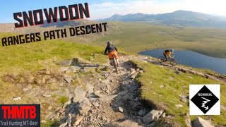
trail: Snowdon Ranger
12:02 |
121 |
May 13, 2024 , Llanberis

trail: Snowdon Ranger
0:44 |
307 |
Jun 23, 2021 , Llanberis
Recent Trail Reports
| status | trail | date | condition | info | user |
|---|---|---|---|---|---|
| Snowdon Ranger | Jul 6, 2026 @ 6:30pm (Europe/Isle_of_Man) 3 days | Ideal | Matiasnombarasco | ||
| Bwlch Maes Gwyn (Telegraph Valley) | Oct 11, 2025 @ 7:30am (Europe/Isle_of_Man) Oct 10, 2025 | Ideal | scblurlt |
Activity Feed
| username | action | type | title | date |
|---|---|---|---|---|
| Matiasnombarasco | add | report | activity #98592520 | Jul 6, 2026 @ 12:26pm 3 days |
| yman98 | wishlist | trail | activity #96984011 | Jun 14, 2026 @ 10:28am Jun 14, 2026 |
| yman98 | wishlist | route | activity #96983938 | Jun 14, 2026 @ 10:28am Jun 14, 2026 |
| SteveIunGQa | wishlist | route | activity #96502817 | Jun 7, 2026 @ 3:35pm Jun 7, 2026 |
| 2kguxa | wishlist | trail | activity #92724267 | Apr 16, 2026 @ 8:07am Apr 16, 2026 |
Recent Comments
| username | type | title | comment | date |
|---|---|---|---|---|
| trail | Completely sanitized graded gravel path with... | Oct 17, 2022 @ 10:44am Oct 17, 2022 | ||
| trail | Steep and rocky downhill, it is fun, however,... | Jun 30, 2022 @ 9:47am Jun 30, 2022 |
Activity Type Stats
| activitytype | trails | distance | descent | descent distance | total vertical | rating | global rank | state rank | photos | reports | routes | ridelogs |
|---|---|---|---|---|---|---|---|---|---|---|---|---|
| Mountain Bike | 2 | 5 miles | 3,353 ft | 4 miles | 2,677 ft | #4,974 | #175 | 17 | 24 | 2 | 4,203 | |
| E-Bike | 1 | 2 miles | 617 ft | 1 mile | 610 ft | #7,404 | #327 | 23 | 1 | 796 | ||
| Horse | 2 | 5 miles | 3,353 ft | 4 miles | 2,677 ft | 4 | ||||||
| Hike | 18 | 5 miles | 3,353 ft | 4 miles | 2,677 ft | #6,787 | #181 | 24 | 1,784 | |||
| Trail Running | 18 | 5 miles | 3,353 ft | 4 miles | 2,677 ft | #8,138 | #248 | 24 | 204 |
- By ko-p & contributors
- Admins: TCNW
- #25744 - 3,729 views
- llanberis activity log | embed map of Llanberis mountain bike trails | llanberis mountain biking points of interest
Downloading of trail gps tracks in kml & gpx formats is enabled for Llanberis.
You must login to download files.