close
-
Layers w
- Weather Layers
- Pro
- Pro
- Pro
- Pro
- Pro
- Pro
- More Layers
- Pro
- Pro
- Pro
- Pro
-
Upgrade to

3D
Trail Conditions
- Unknown
- Snow Groomed
- Snow Packed
- Snow Covered
- Snow Cover Partial
- Freeze/thaw Cycle
- Icy
- Prevalent Mud
- Wet
- Variable
- Ideal
- Dry
- Very Dry
Trail Flow (Ridden Direction)
Trailforks scans users ridelogs to determine the most popular direction each trail is ridden. A good flowing trail network will have most trails flowing in a single direction according to their intension.
The colour categories are based on what percentage of riders are riding a trail in its intended direction.
The colour categories are based on what percentage of riders are riding a trail in its intended direction.
- > 96%
- > 90%
- > 80%
- > 70%
- > 50%
- < 50%
- bi-directional trail
- no data
Trail Last Ridden
Trailforks scans ridelogs to determine the last time a trail was ridden.
- < 2 days
- < 1 week
- < 2 weeks
- < 1 month
- < 6 months
- > 6 months
Trail Ridden Direction
The intended direction a trail should be ridden.
- Downhill Only
- Downhill Primary
- Both Directions
- Uphill Primary
- Uphill Only
- One Direction
Contribute Details
Colors indicate trail is missing specified detail.
- Description
- Photos
- Description & Photos
- Videos
Trail Popularity ?
Trailforks scans ridelogs to determine which trails are ridden the most in the last 9 months.
Trails are compared with nearby trails in the same city region with a possible 25 colour shades.
Think of this as a heatmap, more rides = more kinetic energy = warmer colors.
- most popular
- popular
- less popular
- not popular
ATV/ORV/OHV Filter
Max Vehicle Width
inches
US Cell Coverage
Legend

Radar Time
Activity Recordings
Trailforks uses anonymized public activity data.
?
Activity Recordings
Trailforks uses anonymized public activity data.
?
Personal Heatmap
▶
Activity Types
all
/
none
▶
Options
2
Date range
month
–
Winter Trails
Warning
A routing network for winter maps does not exist. Selecting trails using the winter trails layer has been disabled.
Missing Trails
Most Popular
Least Popular
Trails are colored based on popularity. The more popular a trail is, the more red. Less popular trails trend towards green.
Jump Magnitude Heatmap
Heatmap of where riders jump on trails. Zoom in to see individual jumps, click circles to view jump details.
BC Backroad Status
![map legend]()
Service Road Atlas is a free to use, community-driven service for viewing and creating reports on the numerous back-country service roads around B.C. and Alberta.

Slope Aspect
Direction the slope faces
Trails Deemphasized
Trails are shown in grey.
Only show trails with no bike usage.
Suggested Layers
Based on selected activity type
Save the current map location and zoom level as your default home location whenever this page is loaded.
Save
No description for Lund has been added yet!
Login or register to submit one.
This region uses the Uk/Euro style trail grading system.
Activities Click to view
- Mountain Bike
85 trails
- E-Bike
6 trails
- Adaptive Bike
0 trails
- Winter Fat Bike
0 trails
- Hike
86 trails
- Trail Running
86 trails
Region Details
- 35
- 3
- 45
- 2
Region Status
Open as of Apr 28, 2026Stats
- Avg Trail Rating
- Trails (view details)
- 91
- Trails Mountain Bike
- 85
- Trails E-Bike
- 6
- Trails Hike
- 86
- Trails Trail Running
- 86
- Total Distance
- 59 miles
- Total Descent Distance
- 24 miles
- Total Descent
- 3,643 ft
- Total Vertical
- 519 ft
- Highest Trailhead
- 554 ft
- Reports
- 343
- Photos
- 41
- Ridden Counter
- 7,086
Sub Regions
-
Häckeberga & Romeleåsen
- 1
- 38
-
Klosterängshöjden
- 2
- 2
-
Skrylle
- 1
- 4
Popular Lund Mountain Biking Trails
• 100 ★ 4.0 • 633 ft • 5 ft • 314 •
This is the southern part of "Vita slingan".
• 100 ★ 0.0 • 2,575 ft • 53 ft • 309 •
This is the common northern part of "Vita slingan" reaching trough Björnstorp and Klinten.
• 80 ★ 0.0 • 1,266 ft • 0 ft • 232 •
This is the southern part of "Vita slingan".
• 75 ★ 4.0 • 4 miles • 289 ft • 188 •
Technical track without climbing or any major descending parts. Some minor rockgardens and smal berms. The track does require medium skills to enjoy, but if some steps here and there are tolerated, the absence of climbs allows not as...
• 65 ★ 3.9 • 4,649 ft • 101 ft • 184 •
This is the northern part of "Vita slingan" reaching trough Björnstorp and Klinten.
• 60 ★ 3.5 • 4 miles • 305 ft • 129 •
Family friendly, but could require some walking (max 50m sections). Technical trail with roots and some rocks, depending on season muddy sections must be taken into consideration!
• 95 ★ 0.0 • 4,728 ft • 26 ft • 118 •
Popular blue difficulty singletrack. This mountain bike primary trail can be used both directions. On average it takes 6 minutes to complete this trail.
• 100 ★ 0.0 • 771 ft • 0 ft • 115 •
Popular blue difficulty singletrack. This mountain bike primary trail can be used both directions. On average it takes minutes to complete this trail.
Lund Mountain Bike Routes
★ 3.8 • 12 miles • 739 ft • 18 • Loop •
One of three MTB routes managed by MTB-Stigar Genarp (see Facebook link).
7 miles • 384 ft • 6 • Loop •
Technical track without climbing or any major descending parts. Some minor rockgardens and smal berms. The...
10 miles • 1,037 ft • 18 • Loop •
One of three MTB routes managed by MTB-Stigar Genarp (see Facebook link).
7 miles • 476 ft • 11 • Loop •
One of three MTB routes managed by MTB-Stigar Genarp (see Facebook link).
• 9 miles • 576 ft • 6 •
• 7 miles • 419 ft • 4 •
Photos of Lund Mountain Bike
Videos of Lund Mountain Bike
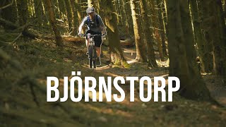
trail: Skåneleden Häckeberga
19:12 |
360 |
Jan 14, 2023 , Lund

29:17 |
184 |
Jan 14, 2023
trail: Skrylle Track
2:15 |
583 |
Jun 9, 2020 , Lund
Recent Trail Reports
| status | trail | date | condition | info | user |
|---|---|---|---|---|---|
| Vita Slingan Björnstorp In/Ut | Apr 28, 2026 @ 4:48pm (Europe/Copenhagen) Apr 28, 2026 | Ideal | nordictallrider | ||
| Skåneleden Höje Å | Apr 28, 2026 @ 4:48pm (Europe/Copenhagen) Apr 28, 2026 | Ideal | nordictallrider | ||
| Skåneleden Häckeberga | Apr 28, 2026 @ 4:48pm (Europe/Copenhagen) Apr 28, 2026 | Ideal | nordictallrider | ||
| Vita Slingan Dörrödsbäcken | Apr 28, 2026 @ 4:48pm (Europe/Copenhagen) Apr 28, 2026 | Ideal | nordictallrider | ||
| Vita Slingan Huggorma | Apr 28, 2026 @ 4:48pm (Europe/Copenhagen) Apr 28, 2026 | Ideal | nordictallrider | ||
| Vita Slingan Lövdalshus | Apr 28, 2026 @ 4:48pm (Europe/Copenhagen) Apr 28, 2026 | Dry | nordictallrider | ||
| Vita Slingan Häckebergasjön | Apr 28, 2026 @ 4:48pm (Europe/Copenhagen) Apr 28, 2026 | Ideal | nordictallrider | ||
| Vita Slingan Skoggårdsvägen | Apr 28, 2026 @ 4:48pm (Europe/Copenhagen) Apr 28, 2026 | Ideal | nordictallrider | ||
| Vita Slingan Degerberga | Apr 28, 2026 @ 4:48pm (Europe/Copenhagen) Apr 28, 2026 | Ideal | nordictallrider | ||
| Skåneleden Nötabo | Apr 28, 2026 @ 4:48pm (Europe/Copenhagen) Apr 28, 2026 | Dry | nordictallrider |
Activity Feed
| username | action | type | title | date |
|---|---|---|---|---|
| SuzziT | wishlist | route | activity #94998233 | May 18, 2026 @ 1:47pm May 18, 2026 |
| nordictallrider | add | report | activity #93630703 and 13 more | Apr 28, 2026 @ 11:42pm Apr 28, 2026 |
| GoAllIn | add | report | activity #92711068 and 2 more | Apr 16, 2026 @ 2:21am Apr 16, 2026 |
| plaidshirtdude | wishlist | route | activity #90972130 | Mar 21, 2026 @ 4:01am Mar 21, 2026 |
| FredrikH93S2v | ridden | route | activity #90917753 and 1 more | Mar 20, 2026 @ 8:01am Mar 20, 2026 |
Recent Comments
| username | type | title | comment | date |
|---|---|---|---|---|
| trail | Lätt att åka vilse och mycket rötter och... | Aug 4, 2022 @ 2:40am Aug 4, 2022 | ||
| trail | A small fun trail. Maybe not worth a drive to... | Jul 29, 2022 @ 1:38am Jul 29, 2022 | ||
| trail | Excellent trail to train your flow over roots... | Jul 29, 2022 @ 1:33am Jul 29, 2022 | ||
| trail | Mycket rötter och stenigt på sina ställen,... | Sep 28, 2021 @ 12:34pm Sep 28, 2021 | ||
| trail | Good fun! Dry Easter 2021 | Apr 4, 2021 @ 7:13am Apr 4, 2021 |
Local Badges
-

Completionist0 awarded -

Epic Mountain Bike Climb 2k12 awarded -

Climbing 10k Badge45 awarded -

Mountain Biking 100k Badge0 awarded -

Epic Ride Descent 2k12 awarded -

Descent 10k Badge46 awarded
Bike & Skill Parks
| name | type | city | rating |
|---|---|---|---|
| Ilstorp motocross | skill park | Lund |
Activity Type Stats
| activitytype | trails | distance | descent | descent distance | total vertical | rating | global rank | state rank | photos | reports | routes | ridelogs |
|---|---|---|---|---|---|---|---|---|---|---|---|---|
| Mountain Bike | 85 | 55 miles | 3,465 ft | 23 miles | 518 ft | #1,312 | #71 | 41 | 343 | 3 | 17,318 | |
| E-Bike | 6 | 2 miles | 13 ft | 2,930 ft | 69 ft | #2,649 | #64 | 289 | 613 | |||
| Hike | 86 | 56 miles | 3,481 ft | 23 miles | 518 ft | #2,217 | #90 | 330 | 325 | |||
| Trail Running | 86 | 56 miles | 3,481 ft | 23 miles | 518 ft | #1,880 | #95 | 330 | 1 | 831 |
Frequently Asked Questions About Lund
▼
What are the best places to ride in Lund?
Lund has 3 areas to explore for mountain biking. The top rated areas are:
▼
What are the highest rated mountain biking trails in Lund?
The highest rated mountain biking trails in Lund are:
- Varpinge Miki Trail (4.1/5)
- Light Waves (4/5)
- Vita Slingan Häckebergavägen (4/5)
- Klosterängshöjden (4/5)
- Skrylle Track (3.9/5)
▼
What is the best time of the year to ride in Lund?
Based on ride log data, the most popular months to ride in Lund are:
- August (87 activities)
- July (86 activities)
- May (79 activities)
▼
Where can I park to ride in Lund?
There are 5 parking locations listed in Lund. The most popular parking spots are: View all parking and trailhead locations on the map to plan your visit.
Activities
- By wijkd & contributors
- Admins: ollesvenskonthetrail, JALLE, OrjanX, martinlindstr, gujo82, c-oma
- #10257 - 10,116 views
- lund activity log | embed map of Lund mountain bike trails | lund mountain biking points of interest
Downloading of trail gps tracks in kml & gpx formats is enabled for Lund.
You must login to download files.