close
-
Layers w
- Weather Layers
- Pro
- Pro
- Pro
- Pro
- Pro
- Pro
- More Layers
- Pro
- Pro
- Pro
- Pro
-
Upgrade to

3D
Trail Conditions
- Unknown
- Snow Groomed
- Snow Packed
- Snow Covered
- Snow Cover Partial
- Freeze/thaw Cycle
- Icy
- Prevalent Mud
- Wet
- Variable
- Ideal
- Dry
- Very Dry
Trail Flow (Ridden Direction)
Trailforks scans users ridelogs to determine the most popular direction each trail is ridden. A good flowing trail network will have most trails flowing in a single direction according to their intension.
The colour categories are based on what percentage of riders are riding a trail in its intended direction.
The colour categories are based on what percentage of riders are riding a trail in its intended direction.
- > 96%
- > 90%
- > 80%
- > 70%
- > 50%
- < 50%
- bi-directional trail
- no data
Trail Last Ridden
Trailforks scans ridelogs to determine the last time a trail was ridden.
- < 2 days
- < 1 week
- < 2 weeks
- < 1 month
- < 6 months
- > 6 months
Trail Ridden Direction
The intended direction a trail should be ridden.
- Downhill Only
- Downhill Primary
- Both Directions
- Uphill Primary
- Uphill Only
- One Direction
Contribute Details
Colors indicate trail is missing specified detail.
- Description
- Photos
- Description & Photos
- Videos
Trail Popularity ?
Trailforks scans ridelogs to determine which trails are ridden the most in the last 9 months.
Trails are compared with nearby trails in the same city region with a possible 25 colour shades.
Think of this as a heatmap, more rides = more kinetic energy = warmer colors.
- most popular
- popular
- less popular
- not popular
ATV/ORV/OHV Filter
Max Vehicle Width
inches
US Cell Coverage
Legend

Radar Time
Activity Recordings
Trailforks uses anonymized public activity data.
?
Activity Recordings
Trailforks uses anonymized public activity data.
?
Personal Heatmap
▶
Activity Types
all
/
none
▶
Options
2
Date range
month
–
Winter Trails
Warning
A routing network for winter maps does not exist. Selecting trails using the winter trails layer has been disabled.
Missing Trails
Most Popular
Least Popular
Trails are colored based on popularity. The more popular a trail is, the more red. Less popular trails trend towards green.
Jump Magnitude Heatmap
Heatmap of where riders jump on trails. Zoom in to see individual jumps, click circles to view jump details.
BC Backroad Status
![map legend]()
Service Road Atlas is a free to use, community-driven service for viewing and creating reports on the numerous back-country service roads around B.C. and Alberta.

Slope Aspect
Direction the slope faces
Trails Deemphasized
Trails are shown in grey.
Only show trails with no bike usage.
Suggested Layers
Based on selected activity type
Save the current map location and zoom level as your default home location whenever this page is loaded.
SaveMaple Valley is home to 4 underrated and expansive mostly XC riding areas. Lake Sawyer is an older development, and the largest of the 4, offering mostly twisty, narrow XC singletrack. It connects to BDOS & Summit Ridge across a road. Black Diamond Open Space, or BDOS for short, is a project by Evergreen Mtb Alliance in conjunction with King County parks. It offers mostly more flowy XC singletrack, with some downhill trails. It connects to Summit Ridge, via the 'Connector' trail off Route 66, connects to Henry's Ridge across the train tracks on both Route 66 and Master Link, and connects to Lake Sawyer across the road. Summit Ridge is probably the most famous of the 4. While easily the smallest, it offers the only real downhill and jump trails of the area, such as Gannonball, one of the largest Jump Trails in Washington. It has both a freeride park with trails for every difficulty and an XC area, which also contains many high rated trails. It connects to BDOS at it's main entrance, and to Lake Sawyer across the road. Finally, Henry's Ridge is another area. Similar to Lake Sawyer and BDOS, it's a mostly XC area with some more flowy trails. It has more elevation change on its XC trails than other areas, but there aren't very many real climbs or descents to be found. It connects to BDOS across the rail tracks.
Activities Click to view
- Mountain Bike
216 trails
- E-Bike
41 trails
- Gravel Bike
0 trails
- Adaptive Bike
0 trails
- Winter Fat Bike
0 trails
- Horse
30 trails
- Hike
250 trails
- Trail Running
251 trails
- Dirtbike/Moto
4 trails
- Observed Trials
4 trails
- ATV/ORV/OHV
4 trails
Region Details
- 29
- 75
- 91
- 10
- 3
Region Status
Open as of 6 hoursLocal Trail Association
Stats
- Avg Trail Rating
- Trails (view details)
- 254
- Trails Mountain Bike
- 235
- Trails E-Bike
- 41
- Trails Horse
- 30
- Trails Hike
- 251
- Trails Trail Running
- 251
- Trails Dirtbike/Moto
- 4
- Trails Observed Trials
- 4
- Trails ATV/ORV/OHV
- 4
- Total Distance
- 127 miles
- Total Descent
- 12,493 ft
- Total Vertical
- 829 ft
- Highest Trailhead
- 870 ft
- Reports
- 5,386
- Photos
- 694
- Ridden Counter
- 103,401
Sub Regions
-
Black Diamond Open Space
- 13
- 10
- 2
-
Cedar Creek Park
- 4
- 6
-
Henry's Ridge Open Space
- 12
- 22
- 4
-
Kanaskat-Palmer State Park
- 12
- 1
-
Lake Sawyer
- 9
- 47
- 2
-
Legacy Park
- 16
-
Summit Ridge
- 7
- 5
- 3
- 4
Popular Maple Valley Mountain Biking Trails
• 90 ★ 3.9 • 2,208 ft • 66 ft • 1,755 •
Easygoing, machine-built beginner loop. Fast and flowy for the most part with an abundance of berms and rollers to pump your way through. This is a great first trail to take beginners on, and in turn, very kid-friendly as well. Also...
• 100 ★ 3.7 • 1,640 ft • 8 ft • 1,737 •
Mix of an old primitive trail ( ) and new machine built flow ( ). A few of the old sections have been reworked to drain and flow better, while a few of the original sections remain untouched, or remain as side options to the new...
• 95 ★ 3.9 • 4,183 ft • 124 ft • 1,733 •
Flowy climb and descent. Crank your way to the top whilst carving and pumping your way though an abundance of berms and rollers, and then rip back down through a fast descent with small tables, whoops, mid sized gaps, and even a short,...
• 100 ★ 4.5 • 616 ft • 0 ft • 1,683 •
One of the biggest jump lines in Washington. The jumps and berms are built to perfection, and the whole line is just buttery. Biggest hit comes in at about 40 feet across.
• 100 ★ 4.3 • 728 ft • 0 ft • 1,677 •
A fast and flowy trail with big, long berms, tables, drops, and rollers.
• 100 ★ 4.3 • 1,778 ft • 0 ft • 1,639 •
Fast and flowy descent that features tabletop jumps, rollers that can be jumped as doubles, small whoops, and a huge berm to rail right at the start.
Maple Valley Mountain Bike Routes
11 miles • 667 ft • 12 • Loop •
Fun route for groups with varied rider skill & fitness, and a good look at what's available while...
14 miles • 1,196 ft • 20 • Loop •
A fairly extensive tour of Henry's Ridge Open Space, that takes most blues and the few "blacks" from the...
6 miles • 484 ft • 11 • Out & Back •
A planned route of some of the fun things at Black Diamond/Henry's. Without focusing on the popular...
13 miles • 1,167 ft • 19 •
This route links three sections of Henry's Ridge in a fluid 13 mile course.
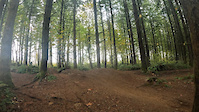
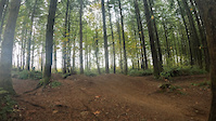
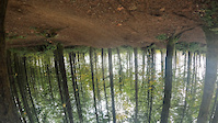
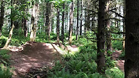
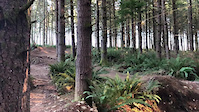
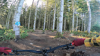
Photos of Maple Valley Mountain Bike
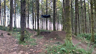
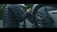
Videos of Maple Valley Mountain Bike
trail: ATM
0:10 |
173 |
Oct 23, 2022
trail: ATM
0:10 |
|
Oct 23, 2022
trail: ATM
0:10 |
|
Oct 23, 2022
trail: Gannonball Run
0:07 |
430 |
Jul 25, 2022
trail: Gannonball Run
0:16 |
204 |
Jul 25, 2022
trail: ATM
0:10 |
337 |
Feb 25, 2021
trail: ATM
0:00 |
147 |
Feb 2, 2021
trail: ATM
0:45 |
133 |
Nov 29, 2020
Current Trail Warnings
| status | trail | date | condition | user | info |
|---|---|---|---|---|---|
| Twisted Sister | Jun 27, 2026 @ 4:51pm (America/Los_Angeles) Jun 27, 2026 | Unknown | boxxerace TRAILFORKS | From: Alvin Timm on PNW Mountain Bikers:... |
Recent Trail Reports
| status | trail | date | condition | info | user |
|---|---|---|---|---|---|
| Tribulation | Jul 12, 2026 @ 7:01am (America/Los_Angeles) 6 hours | Ideal | andyrusho | ||
| Gravel Road | Jul 9, 2026 @ 10:09pm (America/Los_Angeles) 3 days | Dry | Bethte8jQ4 | ||
| Cumberland Connector | Jul 9, 2026 @ 10:09pm (America/Los_Angeles) 3 days | Dry | Bethte8jQ4 | ||
| Salvation | Jul 9, 2026 @ 7:12pm (America/Los_Angeles) 3 days | Ideal | lloigor | ||
| Python | Jul 5, 2026 @ 11:26am (America/Vancouver) Jul 5, 2026 | Dry | GregWlVrWj | ||
| Cedar River Trail | Jun 28, 2026 @ 5:14am (America/Vancouver) Jun 28, 2026 | Ideal | theprofessionaljerry | ||
| Little Something Special | Jun 26, 2026 @ 3:48pm (America/Los_Angeles) Jun 26, 2026 | Ideal | lloigor | ||
| Anaconda | Jun 22, 2026 @ 2:37pm (America/Los_Angeles) Jun 22, 2026 | Dry | Jburris | ||
| Crooshal | Jun 11, 2026 @ 5:37pm (America/Vancouver) Jun 11, 2026 | Ideal | Awkragt | ||
| Supercharger | Jun 11, 2026 @ 5:37pm (America/Vancouver) Jun 11, 2026 | Ideal | Awkragt |
Activity Feed
| username | action | type | title | date |
|---|---|---|---|---|
| andyrusho | add | report | activity #99017120 | Jul 12, 2026 @ 7:14am 6 hours |
| IG7JA2A7 | wishlist | region | activity #98885310 | Jul 10, 2026 @ 3:28pm 2 days |
| Bethte8jQ4 | add | report | activity #98835197 and 1 more | Jul 9, 2026 @ 10:15pm 3 days |
| lloigor | add | report | activity #98827684 and 1 more | Jul 9, 2026 @ 7:07pm 3 days |
| GregWlVrWj | add | report | activity #98531346 | Jul 5, 2026 @ 1:08pm Jul 5, 2026 |
Recent Comments
| username | type | title | comment | date |
|---|---|---|---|---|
| trail | Trail closure around mile 3.5 from Maple... | Jun 14, 2026 @ 3:23pm Jun 14, 2026 | ||
| report | Concur - no snow cover on trail. Full access... | Mar 16, 2026 @ 3:21pm Mar 16, 2026 | ||
| report | Oops, duplicate report | Dec 14, 2025 @ 4:06pm Dec 14, 2025 | ||
| trail | Agreed! Doesn’t look promising going... | Sep 29, 2025 @ 10:36pm Sep 29, 2025 | ||
| trail | There appears to be some logging or major... | Sep 16, 2025 @ 3:34pm Sep 16, 2025 |
Local Badges
-

Completionist4 awarded -

Big Ride 30k2,361 awarded -

Epic Ride 50k916 awarded -

Top 10 Trails82 awarded -
Completionist26 awarded -
Completionist2 awarded
Bike & Skill Parks
| name | type | city | rating |
|---|---|---|---|
| Summit Ridge Skilz Area | skill park | Maple Valley |
Activity Type Stats
| activitytype | trails | distance | descent | descent distance | total vertical | rating | global rank | state rank | photos | reports | routes | ridelogs |
|---|---|---|---|---|---|---|---|---|---|---|---|---|
| Mountain Bike | 216 | 108 miles | 10,902 ft | 51 miles | 830 ft | #131 | #50 | 750 | 5,416 | 12 | 43,234 | |
| E-Bike | 41 | 19 miles | 1,913 ft | 9 miles | 404 ft | #3,458 | #1,218 | 4,605 | 1 | 1,502 | ||
| Horse | 30 | 26 miles | 1,841 ft | 11 miles | 617 ft | #1,387 | #829 | 1,375 | 1 | |||
| Hike | 250 | 122 miles | 10,922 ft | 56 miles | 830 ft | #828 | #381 | 18 | 5,113 | 1 | 1,571 | |
| Trail Running | 251 | 122 miles | 10,922 ft | 56 miles | 830 ft | #939 | #353 | 2 | 5,117 | 1 | 1,837 | |
| Dirtbike/Moto | 4 | 5,003 ft | 95 ft | 3,517 ft | 62 ft | #1,031 | #394 | 1,371 | 11 | |||
| Observed Trials | 4 | 5,003 ft | 95 ft | 3,517 ft | 62 ft | #190 | #34 | 22 | 8 | |||
| ATV/ORV/OHV | 4 | 5,003 ft | 95 ft | 3,517 ft | 62 ft | #782 | #337 | 1,369 | 16 |
Frequently Asked Questions About Maple Valley
▼
What are the best places to ride in Maple Valley?
Maple Valley has 10 areas to explore for mountain biking. The top rated areas are:
▼
What are the highest rated mountain biking trails in Maple Valley?
The highest rated mountain biking trails in Maple Valley are:
- Salvation (4.7/5)
- ATM (4.5/5)
- Blooper Reel (4.3/5)
- Mistress (4.3/5)
- Iron Brigade (4.3/5)
▼
What is the best time of the year to ride in Maple Valley?
Based on ride log data, the most popular months to ride in Maple Valley are:
- July (1,146 activities)
- August (849 activities)
- May (796 activities)
▼
Where can I park to ride in Maple Valley?
There are 24 parking locations listed in Maple Valley. The most popular parking spots are: View all parking and trailhead locations on the map to plan your visit.
Activities
Trails
- By ACree
 & contributors
 - Admins: EMBA-C2S, EMBA-C2S
- #6154 - 22,796 views
- maple valley activity log | embed map of Maple Valley mountain bike trails | maple valley mountain biking points of interest
Downloading of trail gps tracks in kml & gpx formats is enabled for Maple Valley.
You must login to download files.