close
-
Layers w
- Weather Layers
- Pro
- Pro
- Pro
- Pro
- Pro
- Pro
- More Layers
- Pro
- Pro
- Pro
- Pro
-
Upgrade to

3D
Trail Conditions
- Unknown
- Snow Groomed
- Snow Packed
- Snow Covered
- Snow Cover Partial
- Freeze/thaw Cycle
- Icy
- Prevalent Mud
- Wet
- Variable
- Ideal
- Dry
- Very Dry
Trail Flow (Ridden Direction)
Trailforks scans users ridelogs to determine the most popular direction each trail is ridden. A good flowing trail network will have most trails flowing in a single direction according to their intension.
The colour categories are based on what percentage of riders are riding a trail in its intended direction.
The colour categories are based on what percentage of riders are riding a trail in its intended direction.
- > 96%
- > 90%
- > 80%
- > 70%
- > 50%
- < 50%
- bi-directional trail
- no data
Trail Last Ridden
Trailforks scans ridelogs to determine the last time a trail was ridden.
- < 2 days
- < 1 week
- < 2 weeks
- < 1 month
- < 6 months
- > 6 months
Trail Ridden Direction
The intended direction a trail should be ridden.
- Downhill Only
- Downhill Primary
- Both Directions
- Uphill Primary
- Uphill Only
- One Direction
Contribute Details
Colors indicate trail is missing specified detail.
- Description
- Photos
- Description & Photos
- Videos
Trail Popularity ?
Trailforks scans ridelogs to determine which trails are ridden the most in the last 9 months.
Trails are compared with nearby trails in the same city region with a possible 25 colour shades.
Think of this as a heatmap, more rides = more kinetic energy = warmer colors.
- most popular
- popular
- less popular
- not popular
ATV/ORV/OHV Filter
Max Vehicle Width
inches
US Cell Coverage
Legend

Radar Time
Activity Recordings
Trailforks uses anonymized public activity data.
?
Activity Recordings
Trailforks uses anonymized public activity data.
?
Personal Heatmap
▶
Activity Types
all
/
none
▶
Options
2
Date range
month
–
Winter Trails
Warning
A routing network for winter maps does not exist. Selecting trails using the winter trails layer has been disabled.
Missing Trails
Most Popular
Least Popular
Trails are colored based on popularity. The more popular a trail is, the more red. Less popular trails trend towards green.
Jump Magnitude Heatmap
Heatmap of where riders jump on trails. Zoom in to see individual jumps, click circles to view jump details.
BC Backroad Status
![map legend]()
Service Road Atlas is a free to use, community-driven service for viewing and creating reports on the numerous back-country service roads around B.C. and Alberta.

Slope Aspect
Direction the slope faces
Trails Deemphasized
Trails are shown in grey.
Only show trails with no bike usage.
Suggested Layers
Based on selected activity type
Save the current map location and zoom level as your default home location whenever this page is loaded.
SavePopular Trail Networks
view all areas »
No description for Marche has been added yet!
Login or register to submit one.
This region uses the Uk/Euro style trail grading system.
Region Details
- 448
- 95
- 443
- 358
- 9
- 2
Stats
- Avg Trail Rating
- Trails (view details)
- 1,480
- Trails Mountain Bike
- 1,477
- Trails E-Bike
- 1,438
- Trails Gravel Bike
- 1
- Trails Adaptive Bike
- 2
- Trails Winter Fat Bike
- 2
- Trails Horse
- 503
- Trails Hike
- 1,277
- Trails Trail Running
- 1,304
- Trails Dirtbike/Moto
- 549
- Trails Observed Trials
- 62
- Trails ATV/ORV/OHV
- 12
- Trails Snowmobile
- 2
- Trails Snowshoe
- 3
- Trails Downhill Ski
- 9
- Trails Backcountry Ski
- 2
- Trails Nordic Ski
- 9
- Total Distance
- 1,459 miles
- Total Descent
- 432,746 ft
- Total Vertical
- 8,083 ft
- Highest Trailhead
- 8,083 ft
- Reports
- 3,988
- Photos
- 603
- Ridden Counter
- 32,148
Sub Regions
- Ancona (47)
- Chiaravalle (4)
- Fabriano (15)
- Monte Conero (28)
- Chiaravalle (4)
- Ascoli Piceno (114)
- Acquasanta Terme (17)
- Arquata Del Tronto (2)
- Ascoli Piceno (37)
- Comunanza (17)
- Grottammare (4)
- Montegallo (4)
- Montemonaco (16)
- Ripatransone (9)
- Roccafluvione (7)
- Acquasanta Terme (17)
- Fermo (21)
- Amandola (2)
- Fermo (4)
- Montefalcone Appennino (8)
- Montefortino (7)
- Amandola (2)
- Macerata (852)
- Apiro (15)
- Caldarola (48)
- Camerino (47)
- Castelraimondo (14)
- Castelsantangelo Sul Nera (36)
- Cingoli (52)
- Cingoli trail park (41)
- Civitanova Marche (1)
- Esanatoglia (73)
- Fiastra (77)
- Fiuminata (7)
- Matelica (38)
- Monte Cavallo (25)
- Muccia (56)
- Pioraco (10)
- San Severino Marche (46)
- Sarnano (5)
- Sefro (17)
- Serrapetrona (11)
- Serravalle Del Chienti (57)
- Treia (34)
- Urbisaglia (34)
- Ussita (60)
- Valfornace (39)
- Visso (55)
- Apiro (15)
- Pesaro e Urbino (437)
- Acqualagna (13)
- Monte Ronco (9)
- Cagli (79)
- Molleone (28)
- Cantiano (10)
- Monte Catria (10)
- Carpegna (15)
- Colbordolo (10)
- Fossombrone (36)
- Gabicce (17)
- Gradara (4)
- Mercatello Sul Metauro (30)
- Betania - Bruciata (25)
- La Guinza (3)
- Montoro Bike Park (2)
- Mercatino Conca (3)
- Mondolfo (2)
- Monte Porzio (2)
- Montelabbate (1)
- Pergola (16)
- Pesaro (38)
- San Costanzo (6)
- Sassocorvaro Auditore (2)
- Tavoleto (1)
- Tavullia (2)
- Urbania (23)
- Urbino (81)
- Parco Naturale Monte San Bartolo (44)
- Acqualagna (13)
Popular Marche Mountain Biking Trails
• 100 ★ 4.5 • 472 ft • 0 ft • 302 •
Popular red difficulty singletrack. This mountain bike primary trail can be used downhill primary and has a moderate overall physical rating with a 0 ft double black diamond climb. Trail visibility is always easy to follow. On average it takes 1 minutes to complete this trail.
• 100 ★ 4.6 • 1 mile • 5 ft • 174 •
Technical singletrack with roots and loose rocks. Variation of trail 137 Cesane
• 100 ★ 0.0 • 1,519 ft • 18 ft • 154 •
Popular green difficulty doubletrack. This multi-use trail can be used both directions. On average it takes 1 minutes to complete this trail.
• 100 ★ 4.8 • 4,797 ft • 0 ft • 136 •
DH all-mountain type of trail with jumps and other wood structures. Steep rock drops in some parts. Most difficulties are avoidable.
• 85 ★ 4.6 • 4,134 ft • 0 ft • 133 •
Highly rated popular red difficulty singletrack. This mountain bike primary trail can be used downhill only. It features drop. On average it takes 8 minutes to complete this trail.
• 90 ★ 3.0 • 1,135 ft • 16 ft • 132 •
Il sentiero può essere interrotto per il pascolo degli animali, si può scavalcare
Marche Mountain Bike Routes
★ 5.0 • 12 miles • 2,949 ft • 4 • Loop •
Anello enduro che sale per strade, carraie e forestali, e scende per le linee più ripide e dirette di...
★ 4.0 • 5 miles • 1,244 ft • 3 • Loop •
Toccata e fuga per provare le due piste storiche del Frontignano Bike Park. Sneak peek to the two main...
21 miles • 5,672 ft • 3 •
L'appenino perduto con questo giro ci ha lasciato a dir poco senza parole. Dal punto di vista...
18 miles • 4,157 ft • 9 • Loop •
Cingoli Enduro Classic route, best trails in area. Not too hard rideable in every season. - Percorsi...
15 miles • 4,268 ft • 11 •
. . ..................................................................................................
15 miles • 2,979 ft • 4 • Loop •
1000 metri di dislivello in discesa, quasi interamente su single track e solo su discese classificate...
Photos of Marche Mountain Bike
Videos of Marche Mountain Bike
featured
![Frontignano Bike Park]()
trail: Pino Torto Reloaded
3:47 |
80 |
May 16, 2021
trail: Access Monte Bello 1
0:57 |
44 |
Nov 10, 2024
trail: Panoramica
0:57 |
7 |
Feb 7, 2024
trail: Fonte Avellana
0:31 |
61 |
Sep 4, 2020
trail: Sorci Verdi FreeRide
2:48 |
265 |
Jun 22, 2018
trail: Trial
6:38 |
379 |
Oct 13, 2017
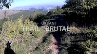
trail: Brutali
4:02 |
104 |
Oct 6, 2017
trail: Dobby Line
0:16 |
195 |
Oct 2, 2017
Current Trail Warnings
| status | trail | date | condition | user | info |
|---|---|---|---|---|---|
| Pintura Di Bolognola to Rifugio Del Fargno Fiastra | Jun 6, 2026 @ 8:32pm (Europe/Rome) Jun 6, 2026 | Variable | fabioooo | la strada é percorribile, noi la abbiamo... | |
| Pintura To Rifugio Vallecaprina Sarnano | Jun 6, 2026 @ 8:28pm (Europe/Rome) Jun 6, 2026 | Unknown | fabioooo | alberi in mezzo alla strada portati da... | |
| Ombriana Betania - Bruciata | Jun 2, 2026 @ 10:32am (Europe/San_Marino) Jun 2, 2026 | Ideal | Ignaz72 | E-Bike Sembra che non ci passi nessuno da molto... |
Recent Trail Reports
Activity Feed
| username | action | type | title | date |
|---|---|---|---|---|
| FABIOSBIKE | add | report | activity #97618498 and 2 more | Jun 23, 2026 @ 5:02am 2 hours |
| at1839paolo | add | report | activity #97550700 and 2 more | Jun 22, 2026 @ 3:09am 1 day |
| Enricoclimb | add | report | activity #97542290 and 1 more | Jun 21, 2026 @ 9:37pm 1 day |
| Ivy86 | wishlist | region | activity #97381399 | Jun 20, 2026 @ 4:35am Jun 20, 2026 |
| at1839paolo | add | report | activity #97379889 | Jun 20, 2026 @ 4:08am Jun 20, 2026 |
Recent Comments
| username | type | title | comment | date |
|---|---|---|---|---|
| trail | Anche più che blu: S3 pieno con passaggi trial | May 6, 2026 @ 4:04am May 6, 2026 | ||
| trail | Anche qualcosa di più che blu, livello... | May 6, 2026 @ 4:03am May 6, 2026 | ||
| trail | Ripulito e sistemato | Feb 14, 2026 @ 12:57am Feb 14, 2026 | ||
| trail | Perfetto, tutto pulito | Jan 30, 2026 @ 11:57am Jan 30, 2026 | ||
| trail | Perfetto, tutto pulito | Jan 30, 2026 @ 11:56am Jan 30, 2026 |
Local Badges
-

Epic Mountain Bike Climb 2k1 awarded -

10 Green Trails0 awarded -
Epic Mountain Bike Climb 2k0 awarded -
Epic Mountain Bike Climb 2k3 awarded -
Epic Mountain Bike Climb 2k4 awarded -
Epic Mountain Bike Climb 2k1 awarded
Bike & Skill Parks
| name | type | city | rating |
|---|---|---|---|
| Frontignano Bike Park | bike park | Ussita | |
| Pump Track di Pesaro | skill park | Pesaro | |
| corridonia | skill park | Fermo | |
| Fermo MX | skill park | Fermo | |
| Crossdromo B. Tittoni (Cingoli) | skill park | Cingoli |
Local Trail Supporters
![]()
- Hotel Felycita
![]()
![]()
![]()
Activity Type Stats
| activitytype | trails | distance | descent | descent distance | total vertical | rating | global rank | state rank | photos | reports | routes | ridelogs |
|---|---|---|---|---|---|---|---|---|---|---|---|---|
| Mountain Bike | 1,477 | 1,444 miles | 429,154 ft | 734 miles | 7,008 ft | 568 | 3,975 | 25 | 56,882 | |||
| E-Bike | 1,438 | 1,406 miles | 411,755 ft | 712 miles | 7,008 ft | 34 | 3,899 | 17 | 11,051 | |||
| Gravel Bike | 1 | 22 | 968 | |||||||||
| Adaptive Bike | 1 | |||||||||||
| Winter Fat Bike | 2 | 1 | ||||||||||
| Horse | 503 | 539 miles | 111,296 ft | 242 miles | 6,890 ft | 184 | 3 | |||||
| Hike | 1,277 | 1,304 miles | 349,557 ft | 628 miles | 8,084 ft | 3,701 | 4 | 2,182 | ||||
| Trail Running | 1,304 | 1,352 miles | 370,892 ft | 660 miles | 8,084 ft | 3,709 | 4 | 451 | ||||
| Dirtbike/Moto | 549 | 583 miles | 131,909 ft | 271 miles | 5,696 ft | 102 | 1 | 6 | ||||
| Observed Trials | 62 | 37 miles | 6,296 ft | 16 miles | 5,377 ft | 5 | 1 | |||||
| ATV/ORV/OHV | 12 | 18 miles | 1,129 ft | 3 miles | 5,354 ft | 79 | 2 | |||||
| Snowmobile | 2 | 3 miles | 26 ft | 768 ft | 1,378 ft | 2 | ||||||
| Snowshoe | 3 | 3 miles | 180 ft | 2,703 ft | 1,480 ft | 57 | 24 | |||||
| Downhill Ski | 9 | 11 miles | 2,201 ft | 7 miles | 1,503 ft | 54 | 70 | |||||
| Backcountry Ski | 2 | 4,554 ft | 180 ft | 2,703 ft | 1,480 ft | 53 | 84 | |||||
| Nordic Ski | 9 | 13 miles | 2,047 ft | 6 miles | 1,503 ft | 2 | 27 |
Activities
Trails
- By brenthillier
 NSMBA TRAILFORKS & contributors
 - Admins: denitopia, marcoangeletti, cemoorelife, rew187
- #9485 - 10,523 views
- marche activity log | embed map of Marche mountain bike trails | marche mountain biking points of interest
Downloading of trail gps tracks in kml & gpx formats is enabled for Marche.
You must login to download files.