close
-
Layers w
- Weather Layers
- Pro
- Pro
- Pro
- Pro
- Pro
- Pro
- More Layers
- Pro
- Pro
- Pro
- Pro
-
Upgrade to

3D
Trail Conditions
- Unknown
- Snow Groomed
- Snow Packed
- Snow Covered
- Snow Cover Partial
- Freeze/thaw Cycle
- Icy
- Prevalent Mud
- Wet
- Variable
- Ideal
- Dry
- Very Dry
Trail Flow (Ridden Direction)
Trailforks scans users ridelogs to determine the most popular direction each trail is ridden. A good flowing trail network will have most trails flowing in a single direction according to their intension.
The colour categories are based on what percentage of riders are riding a trail in its intended direction.
The colour categories are based on what percentage of riders are riding a trail in its intended direction.
- > 96%
- > 90%
- > 80%
- > 70%
- > 50%
- < 50%
- bi-directional trail
- no data
Trail Last Ridden
Trailforks scans ridelogs to determine the last time a trail was ridden.
- < 2 days
- < 1 week
- < 2 weeks
- < 1 month
- < 6 months
- > 6 months
Trail Ridden Direction
The intended direction a trail should be ridden.
- Downhill Only
- Downhill Primary
- Both Directions
- Uphill Primary
- Uphill Only
- One Direction
Contribute Details
Colors indicate trail is missing specified detail.
- Description
- Photos
- Description & Photos
- Videos
Trail Popularity ?
Trailforks scans ridelogs to determine which trails are ridden the most in the last 9 months.
Trails are compared with nearby trails in the same city region with a possible 25 colour shades.
Think of this as a heatmap, more rides = more kinetic energy = warmer colors.
- most popular
- popular
- less popular
- not popular
ATV/ORV/OHV Filter
Max Vehicle Width
inches
US Cell Coverage
Legend

Radar Time
Activity Recordings
Trailforks uses anonymized public activity data.
?
Activity Recordings
Trailforks uses anonymized public activity data.
?
Personal Heatmap
▶
Activity Types
all
/
none
▶
Options
2
Date range
month
–
Winter Trails
Warning
A routing network for winter maps does not exist. Selecting trails using the winter trails layer has been disabled.
Missing Trails
Most Popular
Least Popular
Trails are colored based on popularity. The more popular a trail is, the more red. Less popular trails trend towards green.
Jump Magnitude Heatmap
Heatmap of where riders jump on trails. Zoom in to see individual jumps, click circles to view jump details.
BC Backroad Status
![map legend]()
Service Road Atlas is a free to use, community-driven service for viewing and creating reports on the numerous back-country service roads around B.C. and Alberta.

Slope Aspect
Direction the slope faces
Trails Deemphasized
Trails are shown in grey.
Only show trails with no bike usage.
Suggested Layers
Based on selected activity type
Save the current map location and zoom level as your default home location whenever this page is loaded.
Save
No description for Marple has been added yet!
Login or register to submit one.
This region uses the Uk/Euro style trail grading system.
Activities Click to view
- Mountain Bike
10 trails
- Gravel Bike
0 trails
- Adaptive Bike
0 trails
- Hike
10 trails
- Trail Running
10 trails
Region Details
- 4
- 5
- 1
Region Status
Open as of Feb 13, 2026Stats
- Avg Trail Rating
- Trails (view details)
- 10
- Trails Mountain Bike
- 10
- Trails Hike
- 10
- Trails Trail Running
- 10
- Total Distance
- 5 miles
- Total Descent
- 1,455 ft
- Total Vertical
- 734 ft
- Highest Trailhead
- 1,064 ft
- Reports
- 65
- Photos
- 19
- Ridden Counter
- 1,510
Sub Regions
-
Roman Lakes
- 5
- 1
Popular Marple Mountain Biking Trails
• 90 ★ 3.0 • 2,669 ft • 0 ft • 153 •
Starts on a wide rocky road by Mellor cross (black lane) then a fairly long fast rolling road section. Come up to a forest and jump onto the track on the right where it gets into some tight single track with a few steps.
• 100 ★ 2.7 • 980 ft • 0 ft • 151 •
Easy and fast descent, take the courners with caution, walkers lurking.
• 40 ★ 3.5 • 2,696 ft • 224 ft • 146 •
Gets very wet (hence the name). An open and often rocky run to/from linnet clough camp site.
• 50 ★ 4.0 • 2,753 ft • 0 ft • 144 •
All on a fairly wide doubletrack lane. Starts with a rocky patch and smooths out for the rest for some fairly fast open turns.
• 70 ★ 0.0 • 1,808 ft • 1 ft • 136 •
Nice and easy descent, fast and cuts through mellor golf club.
• 30 ★ 3.0 • 3,732 ft • 0 ft • 131 •
One descent broken into two by a short road section (circa 50m) rocky on the first stage into singletrack on the second.
Photos of Marple Mountain Bike
Videos of Marple Mountain Bike
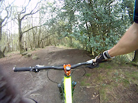
trail: River Run
7:19 |
693 |
Apr 23, 2014
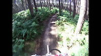
trail: Road Climb
4:23 |
348 |
Jul 9, 2011
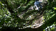
trail: River Run
0:32 |
336 |
May 24, 2011
Recent Trail Reports
| status | trail | date | condition | info | user |
|---|---|---|---|---|---|
| Strawberry Golf Course | Dec 5, 2025 @ 10:22am (Europe/London) Dec 5, 2025 | Wet | Ginmaker63 | ||
| Fox DH | Dec 5, 2025 @ 10:22am (Europe/London) Dec 5, 2025 | Wet | Ginmaker63 | ||
| River Run | Jul 27, 2025 @ 7:12am Jul 27, 2025 | Wet | Gary026 | ||
| Fox pub link | Jun 7, 2022 @ 10:44am Jun 7, 2022 | Ideal | ieuan | ||
| Cable Car | Jun 7, 2022 @ 10:44am Jun 7, 2022 | Wet | ieuan | ||
| Roman Lakes Link | Mar 12, 2022 @ 12:30am Mar 12, 2022 | Ideal | scblurlt | ||
| Road Climb | Apr 18, 2021 @ 1:29am Apr 18, 2021 | Very Dry | Tree68 | ||
| Zig and Zag | Apr 18, 2021 @ 1:29am Apr 18, 2021 | Very Dry | Tree68 | ||
| Mellor Cross | Apr 2, 2021 @ 5:21am Apr 2, 2021 | Ideal | Leonboswell |
Activity Feed
| username | action | type | title | date |
|---|---|---|---|---|
| kezp | wishlist | region | activity #91556822 | Mar 29, 2026 @ 3:20pm Mar 29, 2026 |
| pmacker | wishlist | trail | activity #86527757 | Jan 2, 2026 @ 2:15pm Jan 2, 2026 |
| Ginmaker63 | add | report | activity #85194620 and 1 more | Dec 5, 2025 @ 12:11pm Dec 5, 2025 |
| leeooonnnn | vote | trail | activity #81037744 | Sep 24, 2025 @ 2:56pm Sep 24, 2025 |
| egghead12344 | ridden | trail | activity #79700212 and 1 more | Sep 5, 2025 @ 12:09pm Sep 5, 2025 |
Recent Comments
| username | type | title | comment | date |
|---|---|---|---|---|
| trail | Recently resurfaced, almost a green now | Sep 5, 2022 @ 1:44pm Sep 5, 2022 | ||
| trail | Went down with a more experienced rider being... | Jun 17, 2020 @ 2:14pm Jun 17, 2020 | ||
| trail | Wouldn't list this as a red personally, more... | May 23, 2020 @ 8:05pm May 23, 2020 |
Activity Type Stats
| activitytype | trails | distance | descent | descent distance | total vertical | rating | global rank | state rank | photos | reports | routes | ridelogs |
|---|---|---|---|---|---|---|---|---|---|---|---|---|
| Mountain Bike | 10 | 5 miles | 1,457 ft | 4 miles | 735 ft | #6,332 | #221 | 19 | 65 | 3,258 | ||
| Hike | 10 | 5 miles | 1,457 ft | 4 miles | 735 ft | #9,221 | #279 | 65 | 82 | |||
| Trail Running | 10 | 5 miles | 1,457 ft | 4 miles | 735 ft | #8,672 | #272 | 65 | 62 |
Frequently Asked Questions About Marple
▼
What are the best places to ride in Marple?
Marple has 1 areas to explore for mountain biking. The top rated areas are:
▼
What are the highest rated mountain biking trails in Marple?
The highest rated mountain biking trails in Marple are:
- Fox DH (4/5)
- Mellor Cross (3.8/5)
- River Run (3.7/5)
- Zig and Zag (3.7/5)
- Cable Car (3.5/5)
▼
What is the best time of the year to ride in Marple?
Based on ride log data, the most popular months to ride in Marple are:
- July (70 activities)
- May (17 activities)
- March (11 activities)
▼
Where can I park to ride in Marple?
There are 1 parking locations listed in Marple. The most popular parking spots are:
- By Gnarlybiker11 & contributors
- Admins: wisey, MathieuC, cemoorelife
- #7745 - 6,053 views
- marple activity log | embed map of Marple mountain bike trails | marple mountain biking points of interest
Downloading of trail gps tracks in kml & gpx formats is enabled for Marple.
You must login to download files.