close
-
Layers w
- Weather Layers
- Pro
- Pro
- Pro
- Pro
- Pro
- Pro
- More Layers
- Pro
- Pro
- Pro
- Pro
-
Upgrade to

3D
Trail Conditions
- Unknown
- Snow Groomed
- Snow Packed
- Snow Covered
- Snow Cover Partial
- Freeze/thaw Cycle
- Icy
- Prevalent Mud
- Wet
- Variable
- Ideal
- Dry
- Very Dry
Trail Flow (Ridden Direction)
Trailforks scans users ridelogs to determine the most popular direction each trail is ridden. A good flowing trail network will have most trails flowing in a single direction according to their intension.
The colour categories are based on what percentage of riders are riding a trail in its intended direction.
The colour categories are based on what percentage of riders are riding a trail in its intended direction.
- > 96%
- > 90%
- > 80%
- > 70%
- > 50%
- < 50%
- bi-directional trail
- no data
Trail Last Ridden
Trailforks scans ridelogs to determine the last time a trail was ridden.
- < 2 days
- < 1 week
- < 2 weeks
- < 1 month
- < 6 months
- > 6 months
Trail Ridden Direction
The intended direction a trail should be ridden.
- Downhill Only
- Downhill Primary
- Both Directions
- Uphill Primary
- Uphill Only
- One Direction
Contribute Details
Colors indicate trail is missing specified detail.
- Description
- Photos
- Description & Photos
- Videos
Trail Popularity ?
Trailforks scans ridelogs to determine which trails are ridden the most in the last 9 months.
Trails are compared with nearby trails in the same city region with a possible 25 colour shades.
Think of this as a heatmap, more rides = more kinetic energy = warmer colors.
- most popular
- popular
- less popular
- not popular
ATV/ORV/OHV Filter
Max Vehicle Width
inches
US Cell Coverage
Legend

Radar Time
Activity Recordings
Trailforks uses anonymized public activity data.
?
Activity Recordings
Trailforks uses anonymized public activity data.
?
Personal Heatmap
▶
Activity Types
all
/
none
▶
Options
2
Date range
month
–
Winter Trails
Warning
A routing network for winter maps does not exist. Selecting trails using the winter trails layer has been disabled.
Missing Trails
Most Popular
Least Popular
Trails are colored based on popularity. The more popular a trail is, the more red. Less popular trails trend towards green.
Jump Magnitude Heatmap
Heatmap of where riders jump on trails. Zoom in to see individual jumps, click circles to view jump details.
BC Backroad Status
![map legend]()
Service Road Atlas is a free to use, community-driven service for viewing and creating reports on the numerous back-country service roads around B.C. and Alberta.

Slope Aspect
Direction the slope faces
Trails Deemphasized
Trails are shown in grey.
Only show trails with no bike usage.
Suggested Layers
Based on selected activity type
Save the current map location and zoom level as your default home location whenever this page is loaded.
SaveMillinocket is the gateway to Baxter State Park and the Maine North Woods. The town and its immediate area are quickly becoming an outdoor mecca of Maine. Downtown has a few restuarants and bars and the New England Outdoor Center is quickly developing miles of nordic skiing and mountain biking (non-motorized multiuse). Come here to experience great 4 season outdoor recreation.
Activities Click to view
- Mountain Bike
53 trails
- E-Bike
19 trails
- Adaptive Bike
0 trails
- Winter Fat Bike
1 trails
- Hike
49 trails
- Trail Running
49 trails
- ATV/ORV/OHV
4 trails
- Snowmobile
5 trails
- Snowshoe
48 trails
- Backcountry Ski
17 trails
- Nordic Ski
37 trails
Region Details
- 18
- 3
- 11
- 15
Region Status
Open as of Oct 18, 2025E-Bike Stats
- Global Ranking
- #6,857
- State Ranking
- #2,061
- Trails (view details)
- 19
- Trails Mountain Bike
- 53
- Trails E-Bike
- 19
- Trails Winter Fat Bike
- 1
- Trails Hike
- 49
- Trails Trail Running
- 49
- Trails ATV/ORV/OHV
- 4
- Trails Snowmobile
- 5
- Trails Snowshoe
- 48
- Trails Backcountry Ski
- 17
- Trails Nordic Ski
- 37
- Total Distance
- 10 miles
- Total Descent Distance
- 4 miles
- Total Descent
- 633 ft
- Total Vertical
- 171 ft
- Reports
- 47
- Ridden Counter
- 66
Sub Regions
-
Millinocket Town Trails
- 3
- 3
- 5
-
Northern Timber Cruisers Clubhouse
Popular Millinocket E-Biking Trails
• 5 ★ 4.0 • 1 mile • 37 ft • 1 •
connects from Stearns HS to Alpine Avenue. This key corridor is used by hikers, walkers, runners, and mountain bikers. is a flowy, mountain bike optimized singletrack. Great for all bikes and beginners, but with side hits and optional...
• 5 ★ 4.0 • 1,972 ft • 36 ft • 1 •
runs along the westerly edge of the namesake golf course. It provides more challenging trail close to downtown. On steeper sideslopes for more exposure in spots, the trail also has more rocks, is a bit narrower, and is a bit steeper....
• 5 ★ 4.0 • 1,352 ft • 23 ft • 1 •
The first miles of the 100-mile concept plan produced by IMBA Trail Solutions for Katahain Area Trails and Millinocket. runs along the westerly edge of the namesake golf course. It provides more challenging trail close to downtown. On...
• ★ 0.0 • 2,372 ft • 10 ft • 1 •
is currently built as a connector trail from the end of the gravity trail and back to . It can also be used as a climbing trail for those who would like quick and off of the road access to the Hammond Ridge trail, which can be used as...
• 5 ★ 0.0 • 2 miles • 42 ft • 1 • • snowmobile
is a snowmobile trail that connects the schools to Jerry Pond. There is a more extensive snowmobile/ATV trail network in Millinocket but also provides walking, running, and biking access in the summer. The trail is managed by Northern...
• 5 ★ 5.0 • 1,808 ft • 0 ft •
Millinocket community trails only bike-only beginner descent. is a flowy downhill that is great for kids and newer riders, you should have some mountain biking experience before trying (and put the seat down!).
• 5 ★ 4.5 • 1 mile • 48 ft •
A long time trail used by locals to explore the woods. Classic New England singletrack feel for most of the way. This trail connects the water tower/Connecticut Avenue and state streets development to Jerry Pond recreation area. Its a...
• 5 ★ 0.0 • 1,453 ft • 0 ft •
A classic rake and ride fall line trail that has been around forever.
Photos of Millinocket
Videos of Millinocket
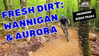
trail: Aurora
9:06 |
1 |
Jun 19, 2026 , Millinocket

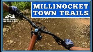
trail: Wannigan
9:06 |
79 |
Sep 10, 2025 , Millinocket
trail: Flowage
15:02 |
80 |
Oct 17, 2024 , Millinocket
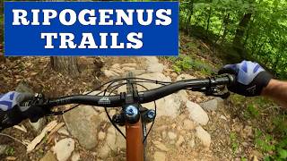
trail: Upper Ripogenus
12:51 |
143 |
Jun 23, 2024 , Millinocket
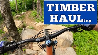
trail: Middle Timber Haul
11:07 |
172 |
Jun 20, 2024 , Millinocket

trail: Blue Ox
8:17 |
190 |
Mar 16, 2024 , Millinocket
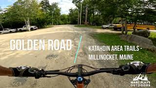
trail: Golden Road
11:43 |
125 |
Mar 10, 2024 , Millinocket
youtuber
![IMBA Trail Solutions Builds: Upper Ripogenus...]()
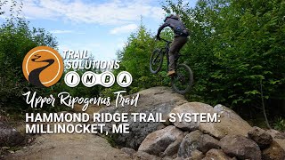
trail: Upper Ripogenus
0:31 |
465 |
Nov 4, 2021 , Millinocket
Recent Trail Reports
| status | trail | date | condition | info | user |
|---|---|---|---|---|---|
| Long Acre | Sep 2, 2023 @ 4:00pm Sep 2, 2023 | Variable | btmspox | ||
| Long Acre | Sep 2, 2023 @ 4:00pm Sep 2, 2023 | Variable | btmspox | ||
| Hillcrest - North | Sep 2, 2023 @ 4:00pm Sep 2, 2023 | Variable | btmspox | ||
| Hillcrest - South | Sep 2, 2023 @ 4:00pm Sep 2, 2023 | Variable | btmspox | ||
| Long Acre | Sep 2, 2023 @ 4:00pm Sep 2, 2023 | Variable | btmspox | ||
| Long Acre | Sep 2, 2023 @ 4:00pm Sep 2, 2023 | Variable | btmspox |
Activity Feed
| username | action | type | title | date |
|---|---|---|---|---|
| MarcPlaysOutdoors | add | video | activity #97306070 | Jun 19, 2026 @ 3:42am Jun 19, 2026 |
| kstew311 | update | trail | activity #92591614 | Apr 14, 2026 @ 5:50am Apr 14, 2026 |
| kstew311 | add | trail | activity #92553374 | Apr 13, 2026 @ 12:35pm Apr 13, 2026 |
| kstew311 | update | region | activity #90940417 | Mar 20, 2026 @ 1:33pm Mar 20, 2026 |
| raywirth | add | karma | activity #89603567 | Feb 26, 2026 @ 5:16pm Feb 26, 2026 |
Recent Comments
| username | type | title | comment | date |
|---|---|---|---|---|
| trail | This trail was so amazing. Local to town so... | Jun 17, 2023 @ 4:18am Jun 17, 2023 | ||
| trail | This trail is also AWESOME! So stoked to have... | Oct 31, 2020 @ 8:20am Oct 31, 2020 |
Activity Type Stats
| activitytype | trails | distance | descent | descent distance | total vertical | rating | global rank | state rank | photos | reports | routes | ridelogs |
|---|---|---|---|---|---|---|---|---|---|---|---|---|
| Mountain Bike | 53 | 44 miles | 3,862 ft | 19 miles | 702 ft | #3,601 | #1,224 | 56 | 62 | 1,282 | ||
| E-Bike | 19 | 10 miles | 633 ft | 4 miles | 171 ft | #6,857 | #2,061 | 47 | 55 | |||
| Winter Fat Bike | 1 | #386 | #1,159 | 1 | ||||||||
| Hike | 49 | 42 miles | 3,327 ft | 17 miles | 689 ft | #5,475 | #1,933 | 62 | 172 | |||
| Trail Running | 49 | 42 miles | 3,327 ft | 17 miles | 689 ft | #4,892 | #1,527 | 62 | 6 | |||
| ATV/ORV/OHV | 4 | 4 miles | 259 ft | 2 miles | 144 ft | #930 | #429 | 2 | ||||
| Snowmobile | 5 | 6 miles | 354 ft | 2 miles | 171 ft | #336 | #175 | 1 | ||||
| Snowshoe | 48 | 42 miles | 3,327 ft | 17 miles | 689 ft | #560 | #210 | 17 | 11 | |||
| Backcountry Ski | 17 | 13 miles | 784 ft | 5 miles | 276 ft | #559 | #168 | 2 | 35 | |||
| Nordic Ski | 37 | 43 miles | 3,281 ft | 17 miles | 689 ft | #600 | #200 | 16 | 138 |
Frequently Asked Questions About Millinocket
▼
What are the best places to ride in Millinocket?
Millinocket has 4 areas to explore for e-biking. The top rated areas are:
▼
What are the highest rated e-biking trails in Millinocket?
The highest rated e-biking trails in Millinocket are:
- Hillcrest - South (0/5)
- Enduro (0/5)
- Raymond North (0/5)
- Raymond South (0/5)
- Flowage (0/5)
▼
What is the best time of the year to ride in Millinocket?
Based on ride log data, the most popular months to ride in Millinocket are:
- September (3 activities)
▼
Where can I park to ride in Millinocket?
There are 5 parking locations listed in Millinocket. The most popular parking spots are: View all parking and trailhead locations on the map to plan your visit.
Activities
Trails
- By brenthillier
 NSMBA TRAILFORKS & contributors
 - Admins: NEMBAEXEC, KAT, OSI
- #20941 - 8,049 views
- millinocket activity log | embed map of Millinocket mountain bike trails | millinocket mountain biking points of interest
Downloading of trail gps tracks in kml & gpx formats is enabled for Millinocket.
You must login to download files.