close
-
Layers w
- Weather Layers
- Pro
- Pro
- Pro
- Pro
- Pro
- Pro
- More Layers
- Pro
- Pro
- Pro
- Pro
-
Upgrade to

3D
Trail Conditions
- Unknown
- Snow Groomed
- Snow Packed
- Snow Covered
- Snow Cover Partial
- Freeze/thaw Cycle
- Icy
- Prevalent Mud
- Wet
- Variable
- Ideal
- Dry
- Very Dry
Trail Flow (Ridden Direction)
Trailforks scans users activity logs to determine the most popular direction each trail is ridden. A good flowing trail network will have most trails flowing in a single direction according to their intension.
The colour categories are based on what percentage of users are riding a trail in its intended direction.
The colour categories are based on what percentage of users are riding a trail in its intended direction.
- > 96%
- > 90%
- > 80%
- > 70%
- > 50%
- < 50%
- bi-directional trail
- no data
Trail Last Ridden
Trailforks scans activity logs to determine the last time a trail was ridden.
- < 2 days
- < 1 week
- < 2 weeks
- < 1 month
- < 6 months
- > 6 months
Trail Ridden Direction
The intended direction a trail should be ridden.
- Downhill Only
- Downhill Primary
- Both Directions
- Uphill Primary
- Uphill Only
- One Direction
Contribute Details
Colors indicate trail is missing specified detail.
- Description
- Photos
- Description & Photos
- Videos
Trail Popularity ?
Trailforks scans activity logs to determine which trails are ridden the most in the last 9 months.
Trails are compared with nearby trails in the same city region with a possible 25 colour shades.
Think of this as a heatmap, more activities = more kinetic energy = warmer colors.
- most popular
- popular
- less popular
- not popular
ATV/ORV/OHV Filter
Max Vehicle Width
inches
US Cell Coverage
Legend

Radar Time
Activity Recordings
Trailforks uses anonymized public activity data.
?
Activity Recordings
Trailforks uses anonymized public activity data.
?
Personal Heatmap
▶
Activity Types
all
/
none
▶
Options
2
Date range
month
–
Winter Trails
Warning
A routing network for winter maps does not exist. Selecting trails using the winter trails layer has been disabled.
Missing Trails
Most Popular
Least Popular
Trails are colored based on popularity. The more popular a trail is, the more red. Less popular trails trend towards green.
Jump Magnitude Heatmap
Heatmap of where users jump on trails. Zoom in to see individual jumps, click circles to view jump details.
BC Backroad Status
![map legend]()
Service Road Atlas is a free to use, community-driven service for viewing and creating reports on the numerous back-country service roads around B.C. and Alberta.

Slope Aspect
Direction the slope faces
Trails Deemphasized
Trails are shown in grey.
Only show trails with no bike usage.
Suggested Layers
Based on selected activity type
Save the current map location and zoom level as your default home location whenever this page is loaded.
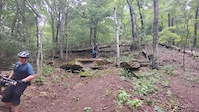
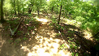
SaveLocated on the southwest edge of Fayetteville in Washington County, Kessler Mountain reaches 1,856 feet above sea level. The area consists of steep bluffs and rock-covered woodlands with miles of nature trails that traverse through stands of old-growth forest, rock out-croppings and many native flora and fauna species. The area presents approximately 376 acres of undeveloped land to the public for a variety of recreation including hiking, birding, mountain biking, nature watching and relaxing. Patrons are requested to sign a log at the parking lot to help the city document the area’s use.
Primary Trail Type: Cross-Country
Files
IMBA Ride Center

Fayetteville
Activities Click to view
- Mountain Bike
32 trails
- E-Bike
33 trails
- Hike
34 trails
- Trail Running
33 trails
Region Details
- 2
- 2
- 2
- 4
- 2
Region Status
Open as of 3 daysStats
- Avg Trail Rating
- Trails (view details)
- 9
- Trails Mountain Bike
- 33
- Trails E-Bike
- 33
- Trails Hike
- 34
- Trails Trail Running
- 33
- Total Distance
- 20 miles
- Total Descent Distance
- 7 miles
- Total Descent
- 1,964 ft
- Total Vertical
- 614 ft
- Highest Trailhead
- 1,819 ft
- Reports
- 946
- Photos
- 87
- Completed Counter
- 11,121
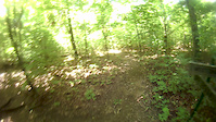
Popular Mt Kessler Mountain Biking Trails
• 95 ★ 4.2 • 3,625 ft • 36 ft • 769 •
New Trail Wood bridge crossing, rocks, hardpack dirt, construction still in progress but mostly done.
• 95 ★ 4.6 • 2 miles • 27 ft • 764 •
New Trail Has 1 big drop on the left, several small jumps, several burms, some rocky obstacles, New alternate to , Mostly intermediate but some Advanced dangerous segments like the drop
• 100 ★ 3.8 • 1,932 ft • 59 ft • 702 •
Popular blue difficulty singletrack. This multi-use trail. On average it takes 4 minutes to complete this trail.
• 70 ★ 4.1 • 1 mile • 0 ft • 582 •
Highly rated popular black diamond difficulty singletrack. This multi-use trail can be used both directions and has a hard overall physical rating with a 0 ft black diamond climb. It features rock garden. Trail visibility is always easy to follow. On average it takes 15 minutes to complete this trail.
• 80 ★ 3.6 • 4,229 ft • 35 ft • 556 •
Popular blue difficulty singletrack. This multi-use trail can be used both directions. On average it takes 8 minutes to complete this trail.
• 85 ★ 4.5 • 1,161 ft • 62 ft • 527 •
Popular blue difficulty singletrack. This multi-use trail can be used both directions and has a moderate overall physical rating with a 62 ft blue climb. On average it takes 5 minutes to complete this trail.
• 65 ★ 4.4 • 2 miles • 132 ft • 487 •
Highly rated moderately popular black diamond difficulty singletrack. This multi-use trail can be used both directions. On average it takes 24 minutes to complete this trail.
• 90 ★ 4.5 • 3,343 ft • 0 ft • 472 •
A downhill-only trail that was built using modern techniques and hundreds of hours of rock work and armoring. Fast and engaging terrain.
Mt Kessler Mountain Bike Routes
12 miles • 1,364 ft • 7 •
Kessler can be a bit of a beatdown, but this route follows the smoother, flowier trails between Kessler...
11 miles • 1,366 ft • 9 •
This is a fun route that highlights some of the best trails on Mt. Kessler.
★ 3.0 • 11 miles • 1,201 ft • 10 •
A fun loop on Mt. Kessler. Add for some added tech
28 miles • 3,506 ft • 35 •
All The Kessler TrailsAll The Kessler TrailsAll The Kessler TrailsAll The Kessler TrailsAll The Kessler...
3 miles • 467 ft • 3 • Point to Point •
Point to point ride on Kessler trail network.
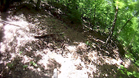
Photos of Mt Kessler Mountain Bike
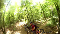
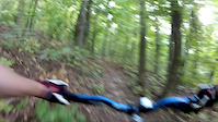
Videos of Mt Kessler Mountain Bike
trail: Precipitous
0:07 |
94 |
Jul 1, 2025
trail: Western Myth
0:07 |
|
Jun 18, 2021
trail: Egg Beater
8:21 |
142 |
Jun 16, 2017
trail: Egg Beater
4:46 |
50 |
Jun 16, 2017
trail: Egg Beater
0:45 |
26 |
Jun 16, 2017
trail: Crazy Mary
17:23 |
464 |
Jun 14, 2017

trail: Crazy Mary
10:52 |
1192 |
Oct 25, 2014
trail: Egg Beater
5:36 |
133 |
Oct 25, 2014
Recent Trail Reports
| status | trail | date | condition | info | user |
|---|---|---|---|---|---|
| Egg Beater | Jul 30, 2026 @ 5:20am (America/Chicago) 3 days | Ideal | robbiethetrailtroll OORC | ||
| Western Myth | Jul 30, 2026 @ 5:19am (America/Chicago) 3 days | Ideal | robbiethetrailtroll OORC | ||
| Spellbound | Jul 28, 2026 @ 4:58am (America/Chicago) Jul 28, 2026 | Ideal | robbiethetrailtroll OORC | ||
| Fayetteville Traverse | Jul 19, 2026 @ 6:35am (America/Chicago) Jul 19, 2026 | Ideal | robbiethetrailtroll OORC | ||
| Escalator | Jul 19, 2026 @ 6:35am (America/Chicago) Jul 19, 2026 | Ideal | robbiethetrailtroll OORC | ||
| Last Call | Jul 19, 2026 @ 6:35am (America/Chicago) Jul 19, 2026 | Ideal | robbiethetrailtroll OORC | ||
| Flight Training | Jul 16, 2026 @ 1:45pm (America/Chicago) Jul 16, 2026 | Variable | robbiethetrailtroll OORC | ||
| Crazy Mary | Apr 23, 2026 @ 2:21pm (America/Chicago) Apr 23, 2026 | Ideal | OzarkMtnBiker | ||
| Chinkapin Oak | Apr 10, 2026 @ 11:37am (America/Indiana/Vincennes) Apr 10, 2026 | Wet | mtnstoke | ||
| Serpentine | Apr 10, 2026 @ 11:37am (America/Indiana/Vincennes) Apr 10, 2026 | Ideal | mtnstoke |
Activity Feed
| username | action | type | title | date |
|---|---|---|---|---|
| robbiethetrailtroll | add | report | activity #100330679 and 1 more | Jul 30, 2026 @ 3:19am 3 days |
| robbiethetrailtroll | add | report | activity #100185963 | Jul 28, 2026 @ 2:58am Jul 28, 2026 |
| robbiethetrailtroll | add | report | activity #99595305 and 2 more | Jul 20, 2026 @ 3:12am Jul 20, 2026 |
| robbiethetrailtroll | add | report | activity #99323798 | Jul 16, 2026 @ 11:46am Jul 16, 2026 |
| Ouachita-Mule | vote | trail | activity #99213140 | Jul 14, 2026 @ 7:38pm Jul 14, 2026 |
Recent Comments
| username | type | title | comment | date |
|---|---|---|---|---|
| trail | Awesome trail but I feel like they... | May 16, 2026 @ 1:13pm May 16, 2026 | ||
| trail | Super fun both directions, I tend to use it to... | Aug 1, 2025 @ 8:40pm Aug 1, 2025 | ||
| trail | Very cool trail! Love the wood work/rock face... | Aug 1, 2025 @ 8:32pm Aug 1, 2025 | ||
| trail | After the big wooden feature and the small... | Jul 22, 2025 @ 6:14pm Jul 22, 2025 | ||
| trail | A super fun older hand cut trail that'll keep... | Nov 14, 2024 @ 3:06pm Nov 14, 2024 |
Nearby Areas
| name | distance | ||||
|---|---|---|---|---|---|
| Centennial Park at Millsap Mountain | 7 | 8 | 14 | 2.4 km | |
| Ramay JH School Trails | 2 | 1 | 2.5 km | ||
| Markham Hill | 2 | 1 | 3.1 km | ||
| Gregory Park | 2 | 1 | 5.1 km | ||
| Mt Sequoyah Woods | 4 | 2 | 5.1 km |
Local Badges
-

Completionist0 awarded
Activity Type Stats
| activitytype | trails | distance | descent | descent distance | total vertical | rating | global rank | state rank | photos | reports | routes | activity logs |
|---|---|---|---|---|---|---|---|---|---|---|---|---|
| Mountain Bike | 32 | 20 miles | 1,965 ft | 7 miles | 614 ft | #3,164 | #1,115 | 91 | 973 | 10 | 8,175 | |
| E-Bike | 33 | 20 miles | 1,965 ft | 7 miles | 614 ft | #4,192 | #1,179 | 1 | 926 | 4 | 531 | |
| Hike | 34 | 20 miles | 1,965 ft | 7 miles | 614 ft | #7,642 | #2,809 | 971 | 2 | 714 | ||
| Trail Running | 33 | 20 miles | 1,965 ft | 7 miles | 614 ft | #6,874 | #2,233 | 971 | 2 | 620 |
Frequently Asked Questions About Mt Kessler
▼
What are the highest rated mountain biking trails in Mt Kessler?
The highest rated mountain biking trails in Mt Kessler are:
- Chinkapin Oak (4.4/5)
- Spellbound (4.3/5)
- Goat Trail (4.2/5)
- Bewitched (4.1/5)
- Fayetteville Traverse (4.1/5)
▼
What is the best time of the year to ride in Mt Kessler?
Based on activity log data, the most popular months to ride in Mt Kessler are:
- September (48 activities)
- October (46 activities)
- July (44 activities)
▼
Where can I park to ride in Mt Kessler?
Check the Mt Kessler trail map for trailhead and parking information. Community members regularly update access and parking details for trails in the area.
▼
What is the longest trail in Mt Kessler?
The longest trail in Mt Kessler is Spellbound at 3.2 miles. View all trails sorted by distance.
Activities
- By brenthillier
 NSMBA TRAILFORKS & contributors
 - Admins: OORC
- #3744 - 22,269 views
- mt kessler activity log | embed map of Mt Kessler mountain bike trails |
Downloading of trail gps tracks in kml & gpx formats is enabled for Mt Kessler.
You must login to download files.