close
-
Layers w
- Weather Layers
- Pro
- Pro
- Pro
- Pro
- Pro
- Pro
- More Layers
- Pro
- Pro
- Pro
- Pro
-
Upgrade to

3D
Trail Conditions
- Unknown
- Snow Groomed
- Snow Packed
- Snow Covered
- Snow Cover Partial
- Freeze/thaw Cycle
- Icy
- Prevalent Mud
- Wet
- Variable
- Ideal
- Dry
- Very Dry
Trail Flow (Ridden Direction)
Trailforks scans users ridelogs to determine the most popular direction each trail is ridden. A good flowing trail network will have most trails flowing in a single direction according to their intension.
The colour categories are based on what percentage of riders are riding a trail in its intended direction.
The colour categories are based on what percentage of riders are riding a trail in its intended direction.
- > 96%
- > 90%
- > 80%
- > 70%
- > 50%
- < 50%
- bi-directional trail
- no data
Trail Last Ridden
Trailforks scans ridelogs to determine the last time a trail was ridden.
- < 2 days
- < 1 week
- < 2 weeks
- < 1 month
- < 6 months
- > 6 months
Trail Ridden Direction
The intended direction a trail should be ridden.
- Downhill Only
- Downhill Primary
- Both Directions
- Uphill Primary
- Uphill Only
- One Direction
Contribute Details
Colors indicate trail is missing specified detail.
- Description
- Photos
- Description & Photos
- Videos
Trail Popularity ?
Trailforks scans ridelogs to determine which trails are ridden the most in the last 9 months.
Trails are compared with nearby trails in the same city region with a possible 25 colour shades.
Think of this as a heatmap, more rides = more kinetic energy = warmer colors.
- most popular
- popular
- less popular
- not popular
ATV/ORV/OHV Filter
Max Vehicle Width
inches
US Cell Coverage
Legend

Radar Time
Activity Recordings
Trailforks uses anonymized public activity data.
?
Activity Recordings
Trailforks uses anonymized public activity data.
?
Personal Heatmap
▶
Activity Types
all
/
none
▶
Options
2
Date range
month
–
Winter Trails
Warning
A routing network for winter maps does not exist. Selecting trails using the winter trails layer has been disabled.
Missing Trails
Most Popular
Least Popular
Trails are colored based on popularity. The more popular a trail is, the more red. Less popular trails trend towards green.
Jump Magnitude Heatmap
Heatmap of where riders jump on trails. Zoom in to see individual jumps, click circles to view jump details.
BC Backroad Status
![map legend]()
Service Road Atlas is a free to use, community-driven service for viewing and creating reports on the numerous back-country service roads around B.C. and Alberta.

Slope Aspect
Direction the slope faces
Trails Deemphasized
Trails are shown in grey.
Only show trails with no bike usage.
Suggested Layers
Based on selected activity type
Save the current map location and zoom level as your default home location whenever this page is loaded.
Save
No description for Myjava has been added yet!
Login or register to submit one.
Activities Click to view
- Mountain Bike
13 trails
- E-Bike
6 trails
- Gravel Bike
0 trails
- Adaptive Bike
0 trails
- Winter Fat Bike
0 trails
- Hike
10 trails
- Trail Running
12 trails
Region Details
- 2
- 1
- 9
- 1
Region Status
Open as of May 3, 2026Stats
- Avg Trail Rating
- Trails (view details)
- 13
- Trails Mountain Bike
- 13
- Trails E-Bike
- 6
- Trails Hike
- 10
- Trails Trail Running
- 12
- Total Distance
- 13 miles
- Total Descent
- 5,417 ft
- Total Vertical
- 1,372 ft
- Highest Trailhead
- 2,272 ft
- Reports
- 74
- Photos
- 51
- Ridden Counter
- 316
Sub Regions
-
Periská
- 1
- 1
Popular Myjava Mountain Biking Trails
• 50 ★ 4.9 • 3,219 ft • 0 ft • 38 •
top of trail is fast with some drops,lower part is very steep and tight switchbacks.finish is on rocks
• 40 ★ 4.0 • 3,117 ft • 6 ft • 25 •
Moderately popular blue difficulty singletrack. This mountain bike primary trail can be used both directions. Trail visibility is always easy to follow. On average it takes 6 minutes to complete this trail.
• 5 ★ 3.8 • 1 mile • 76 ft • 24 •
Less popular blue difficulty singletrack. This mountain bike primary trail can be used one direction and has a hard overall physical rating with a 76 ft blue climb. It features roller coaster and skinny. Trail visibility is sometimes hard to follow. On average it takes 12 minutes to complete this trail.
• 55 ★ 0.0 • 3,507 ft • 0 ft • 18 •
Moderately popular blue difficulty singletrack. This mountain bike primary trail can be used downhill primary and has a moderate overall physical rating with a 0 ft blue climb. Trail visibility is always easy to follow. On average it takes 12 minutes to complete this trail.
• 80 ★ 0.0 • 4,688 ft • 32 ft • 18 •
Popular blue difficulty singletrack. This mountain bike primary trail can be used both directions. On average it takes 7 minutes to complete this trail.
• 70 ★ 0.0 • 1 mile • 75 ft • 18 •
Popular blue difficulty singletrack. This mountain bike primary trail can be used downhill primary and has a moderate overall physical rating. On average it takes 12 minutes to complete this trail.
Myjava Mountain Bike Routes
30 miles • 3,756 ft • 0 •
Okruh Vás prevedie zákutiami a lokálnymi cestičkami regiónu. Prvá polovica trasy vedie prevažne po...
13 miles • 1,783 ft • 0 • Loop •
Krátky, ale zábavný okruh. Strmé výjazdy a jeden technický zjazd z Bradla.
Photos of Myjava Mountain Bike
Videos of Myjava Mountain Bike

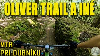
trail: Oliver
0:52 |
688 |
Sep 1, 2013
trail: Oliver
29:24 |
41 |
Aug 26, 2025 , Myjava

trail: Oliver
0:15 |
414 |
Jan 21, 2012
trail: Oliver
0:58 |
145 |
Nov 28, 2011
trail: Oliver
3:43 |
2670 |
Apr 6, 2011
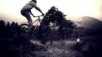
trail: ROTVAJLER
8:07 |
156 |
Nov 15, 2023 , Myjava
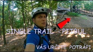
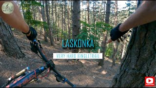
trail: PITBUL
8:44 |
216 |
Sep 2, 2023 , Myjava
trail: Oliver
0:53 |
1606 |
Aug 22, 2010
Recent Trail Reports
| status | trail | date | condition | info | user |
|---|---|---|---|---|---|
| ROTVAJLER | May 3, 2026 @ 11:47am (Europe/Bratislava) May 3, 2026 | Very Dry | katko | ||
| PITBUL | May 3, 2026 @ 11:47am (Europe/Bratislava) May 3, 2026 | Very Dry | katko | ||
| Malá lúka+Hrbáč+údolím | Apr 6, 2025 @ 6:51am Apr 6, 2025 | Unknown | bobris01 | ||
| XC Test M.R. Stefanika | Apr 27, 2024 @ 11:35pm Apr 27, 2024 | Dry | Ixnay | ||
| Kubikov vrch - Machova | Aug 15, 2023 @ 6:00pm Aug 15, 2023 | Ideal | Boris3SCZtO | ||
| Narrow trail | Apr 9, 2021 @ 7:11am Apr 9, 2021 | Ideal | Foxo44 | ||
| Oliver | Sep 13, 2018 @ 12:08pm Sep 13, 2018 | Very Dry | eoiner |
Activity Feed
| username | action | type | title | date |
|---|---|---|---|---|
| punkerpsp | wishlist | trail | activity #95763670 | May 29, 2026 @ 2:45am May 29, 2026 |
| jxxw | update | trail | activity #95024063 | May 19, 2026 @ 12:05am May 19, 2026 |
| katko | add | report | activity #93948984 and 1 more | May 3, 2026 @ 8:15am May 3, 2026 |
| petulo420 | wishlist | trail | activity #82582238 | Oct 18, 2025 @ 10:01am Oct 18, 2025 |
| mtbrajder | add | video | activity #79003695 | Aug 26, 2025 @ 1:39pm Aug 26, 2025 |
Recent Comments
| username | type | title | comment | date |
|---|---|---|---|---|
| report | ziadny trail,neudrziavany | Jul 12, 2023 @ 9:46am Jul 12, 2023 | ||
| trail | Výborný trail,technická spodná... | Apr 26, 2020 @ 5:38am Apr 26, 2020 | ||
| trail | Milé prekvapenie. Horná časť sa nesie v... | Oct 17, 2017 @ 12:28am Oct 17, 2017 | ||
| trail | Hravý hrebeň s plynulou hornou časťou a... | Oct 17, 2017 @ 12:25am Oct 17, 2017 |
Local Badges
-

Epic Mountain Bike Climb 2k23 awarded -

Climbing 10k Badge12 awarded -

Mountain Biking 100k Badge1 awarded -

Epic Ride Descent 2k23 awarded -

Descent 10k Badge12 awarded -

Descent 100k Badge1 awarded
Activity Type Stats
| activitytype | trails | distance | descent | descent distance | total vertical | rating | global rank | state rank | photos | reports | routes | ridelogs |
|---|---|---|---|---|---|---|---|---|---|---|---|---|
| Mountain Bike | 13 | 13 miles | 5,417 ft | 9 miles | 1,371 ft | #3,648 | #41 | 51 | 74 | 2 | 2,568 | |
| E-Bike | 6 | 7 miles | 2,011 ft | 5 miles | 1,280 ft | #2,993 | #40 | 52 | 2 | 487 | ||
| Hike | 10 | 12 miles | 4,623 ft | 8 miles | 1,371 ft | #4,636 | #40 | 68 | 2 | 218 | ||
| Trail Running | 12 | 12 miles | 4,623 ft | 8 miles | 1,371 ft | #4,031 | #40 | 68 | 2 | 18 |
Frequently Asked Questions About Myjava
▼
What are the best places to ride in Myjava?
Myjava has 1 areas to explore for mountain biking. The top rated areas are:
▼
What are the highest rated mountain biking trails in Myjava?
The highest rated mountain biking trails in Myjava are:
- PITBUL (4.4/5)
- ROTVAJLER (4.1/5)
- XC Test M.R. Stefanika (4/5)
- Oliver (4/5)
- Malá lúka+Hrbáč+údolím (3.9/5)
▼
What is the best time of the year to ride in Myjava?
Based on ride log data, the most popular months to ride in Myjava are:
- August (10 activities)
- July (9 activities)
- March (6 activities)
▼
Where can I park to ride in Myjava?
Check the Myjava trail map for trailhead and parking information. Community members regularly update access and parking details for trails in the area.
Activities
Trails
Points of Interest
- By jxxw
 TRAILFORKS & contributors
 - Admins: jxxw
- #24211 - 3,079 views
- myjava activity log | embed map of Myjava mountain bike trails |
Downloading of trail gps tracks in kml & gpx formats is enabled for Myjava.
You must login to download files.