close
-
Layers w
- Weather Layers
- Pro
- Pro
- Pro
- Pro
- Pro
- Pro
- More Layers
- Pro
- Pro
- Pro
- Pro
-
Upgrade to

3D
Trail Conditions
- Unknown
- Snow Groomed
- Snow Packed
- Snow Covered
- Snow Cover Partial
- Freeze/thaw Cycle
- Icy
- Prevalent Mud
- Wet
- Variable
- Ideal
- Dry
- Very Dry
Trail Flow (Ridden Direction)
Trailforks scans users ridelogs to determine the most popular direction each trail is ridden. A good flowing trail network will have most trails flowing in a single direction according to their intension.
The colour categories are based on what percentage of riders are riding a trail in its intended direction.
The colour categories are based on what percentage of riders are riding a trail in its intended direction.
- > 96%
- > 90%
- > 80%
- > 70%
- > 50%
- < 50%
- bi-directional trail
- no data
Trail Last Ridden
Trailforks scans ridelogs to determine the last time a trail was ridden.
- < 2 days
- < 1 week
- < 2 weeks
- < 1 month
- < 6 months
- > 6 months
Trail Ridden Direction
The intended direction a trail should be ridden.
- Downhill Only
- Downhill Primary
- Both Directions
- Uphill Primary
- Uphill Only
- One Direction
Contribute Details
Colors indicate trail is missing specified detail.
- Description
- Photos
- Description & Photos
- Videos
Trail Popularity ?
Trailforks scans ridelogs to determine which trails are ridden the most in the last 9 months.
Trails are compared with nearby trails in the same city region with a possible 25 colour shades.
Think of this as a heatmap, more rides = more kinetic energy = warmer colors.
- most popular
- popular
- less popular
- not popular
ATV/ORV/OHV Filter
Max Vehicle Width
inches
US Cell Coverage
Legend

Radar Time
Activity Recordings
Trailforks uses anonymized public activity data.
?
Activity Recordings
Trailforks uses anonymized public activity data.
?
Personal Heatmap
▶
Activity Types
all
/
none
▶
Options
2
Date range
month
–
Winter Trails
Warning
A routing network for winter maps does not exist. Selecting trails using the winter trails layer has been disabled.
Missing Trails
Most Popular
Least Popular
Trails are colored based on popularity. The more popular a trail is, the more red. Less popular trails trend towards green.
Jump Magnitude Heatmap
Heatmap of where riders jump on trails. Zoom in to see individual jumps, click circles to view jump details.
BC Backroad Status
![map legend]()
Service Road Atlas is a free to use, community-driven service for viewing and creating reports on the numerous back-country service roads around B.C. and Alberta.

Slope Aspect
Direction the slope faces
Trails Deemphasized
Trails are shown in grey.
Only show trails with no bike usage.
Suggested Layers
Based on selected activity type
Save the current map location and zoom level as your default home location whenever this page is loaded.
Save
No description for Naples has been added yet!
Login or register to submit one.
Activities Click to view
- Mountain Bike
52 trails
- E-Bike
10 trails
- Gravel Bike
1 trails
- Adaptive Bike
0 trails
- Horse
8 trails
- Hike
75 trails
- Trail Running
69 trails
- Snowmobile
45 trails
- Snowshoe
22 trails
- Downhill Ski
19 trails
- Nordic Ski
29 trails
Region Details
- 13
- 14
- 13
- 12
Region Status
Open as of Jun 6, 2026Stats
- Avg Trail Rating
- Trails (view details)
- 152
- Trails Mountain Bike
- 52
- Trails E-Bike
- 10
- Trails Gravel Bike
- 1
- Trails Horse
- 8
- Trails Hike
- 75
- Trails Trail Running
- 69
- Trails Snowmobile
- 45
- Trails Snowshoe
- 22
- Trails Downhill Ski
- 19
- Trails Backcountry Ski
- 1
- Trails Nordic Ski
- 29
- Total Distance
- 483 miles
- Total Descent
- 62,220 ft
- Total Vertical
- 1,777 ft
- Highest Trailhead
- 2,469 ft
- Reports
- 260
- Photos
- 36
- Ridden Counter
- 6,507
Sub Regions
-
Camp Cutler
- 1
-
Hickory Ridge
- 4
- 3
- 1
-
High Tor Wildlife Management Area
- 4
- 2
-
Ontario County Park
- 5
- 9
- 9
Popular Naples Mountain Biking Trails
• 90 ★ 3.0 • 689 ft • 65 ft • 260 •
Popular black diamond difficulty singletrack. This mountain bike primary trail. On average it takes minutes to complete this trail.
• 80 ★ 3.0 • 1,298 ft • 22 ft • 229 •
Popular black diamond difficulty singletrack. This mountain bike primary trail can be used both directions. On average it takes 3 minutes to complete this trail.
• 80 ★ 4.0 • 4,204 ft • 130 ft • 215 •
Popular green difficulty singletrack. This mountain bike primary trail can be used both directions. On average it takes 6 minutes to complete this trail.
• 70 ★ 0.0 • 1,690 ft • 145 ft • 203 •
Popular black diamond difficulty singletrack. This mountain bike primary trail can be used both directions. On average it takes 6 minutes to complete this trail.
• 65 ★ 4.0 • 4,601 ft • 82 ft • 203 •
Moderately popular blue difficulty singletrack. This mountain bike primary trail can be used both directions. On average it takes 8 minutes to complete this trail.
• 75 ★ 4.0 • 676 ft • 24 ft • 192 •
Popular green difficulty singletrack. This mountain bike primary trail can be used both directions. On average it takes 1 minutes to complete this trail.
• 75 ★ 2.0 • 4,119 ft • 97 ft • 187 •
Popular green difficulty singletrack. This mountain bike primary trail can be used both directions. On average it takes 4 minutes to complete this trail.
Naples Mountain Bike Routes
7 miles • 772 ft • 10 • Loop •
This is a great figure 8 style loop that gives you a good taste of the park without getting too difficult....
10 miles • 1,570 ft • 0 • Loop •
Park, head up Parish hill rd until you can get to a fire road climb for about 2 miles until you get to...
38 miles • 3,166 ft • 0 • Loop •
Gravel route with lots of climbing
• 16 miles • 1,887 ft • 25 •
• 5 miles • 534 ft • 4 •
Photos of Naples Mountain Bike
Videos of Naples Mountain Bike

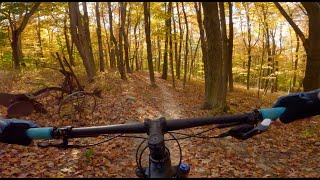
trail: Sanctuary
20:13 |
46 |
Oct 31, 2025 , Naples

trail: Hoverfly
20:13 |
34 |
Oct 31, 2025 , Naples
trail: Hemlock
20:13 |
38 |
Oct 31, 2025 , Naples
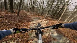
trail: BHT - Ontario Park
4:59 |
524 |
Dec 5, 2011
trail: Hoverfly
3:00 |
214 |
Nov 5, 2024 , Naples
Current Trail Warnings
| status | trail | date | condition | user | info |
|---|---|---|---|---|---|
| Seedling | May 30, 2026 @ 1:14pm (America/New_York) May 30, 2026 | Prevalent Mud | MatLevine NTC | Significant muddy stretches persist.... |
Recent Trail Reports
| status | trail | date | condition | info | user |
|---|---|---|---|---|---|
| Park Trail (Red Connector) | Jun 1, 2026 @ 2:59pm (America/Toronto) Jun 1, 2026 | Ideal | rw420 | ||
| Sanctuary | May 30, 2026 @ 1:32pm (America/New_York) May 30, 2026 | Variable | MatLevine NTC | ||
| Plow | May 30, 2026 @ 1:30pm (America/New_York) May 30, 2026 | Variable | MatLevine NTC | ||
| Hoverfly | May 30, 2026 @ 1:29pm (America/New_York) May 30, 2026 | Variable | MatLevine NTC | ||
| Barred owl | May 30, 2026 @ 1:27pm (America/New_York) May 30, 2026 | Variable | MatLevine NTC | ||
| Hemlock | May 30, 2026 @ 1:25pm (America/New_York) May 30, 2026 | Variable | MatLevine NTC | ||
| Homestead | May 30, 2026 @ 1:17pm (America/New_York) May 30, 2026 | Ideal | MatLevine NTC | ||
| Purple Loop Access | May 12, 2026 @ 1:55pm (America/Toronto) May 12, 2026 | Dry | Lakelife4me | ||
| Park Trail | May 12, 2026 @ 1:55pm (America/Toronto) May 12, 2026 | Dry | Lakelife4me | ||
| Green Loop Cutoff | May 12, 2026 @ 1:55pm (America/Toronto) May 12, 2026 | Dry | Lakelife4me |
Activity Feed
| username | action | type | title | date |
|---|---|---|---|---|
| thebooms | wishlist | region | activity #96851046 | Jun 12, 2026 @ 11:52pm 3 hours |
| WebbX | add | report | activity #96399226 | Jun 6, 2026 @ 12:50pm Jun 6, 2026 |
| rw420 | add | report | activity #96039771 | Jun 1, 2026 @ 2:04pm Jun 1, 2026 |
| MatLevine | add | report | activity #95865599 and 8 more | May 30, 2026 @ 10:14am May 30, 2026 |
| aamcgee | wishlist | skillpark | activity #95754115 | May 28, 2026 @ 8:22pm May 28, 2026 |
Recent Comments
| username | type | title | comment | date |
|---|---|---|---|---|
| report | A few persistent muddy spots remain on lower... | Jun 9, 2025 @ 12:34pm Jun 9, 2025 | ||
| trail | Seems like the stripes are all orange now ? | May 31, 2023 @ 10:36am May 31, 2023 | ||
| report | IMI m omm | Aug 14, 2020 @ 6:51am Aug 14, 2020 | ||
| report | Sorry did I I | Aug 14, 2020 @ 6:51am Aug 14, 2020 | ||
| trail | Brown trail, marked with brown spray paint on... | Jul 22, 2020 @ 8:00am Jul 22, 2020 |
Local Badges
-

10 Black Trails83 awarded -

Epic Ride Climb 2k31 awarded -

Climbing 10k Badge23 awarded -

Climbing 100k Badge0 awarded -

Epic Ride Descent 2k31 awarded -

Descent 10k Badge24 awarded
Bike & Skill Parks
| name | type | city | rating |
|---|---|---|---|
| Makepeace Pump Track | skill park | Naples |
Activity Type Stats
| activitytype | trails | distance | descent | descent distance | total vertical | rating | global rank | state rank | photos | reports | routes | ridelogs |
|---|---|---|---|---|---|---|---|---|---|---|---|---|
| Mountain Bike | 52 | 40 miles | 4,859 ft | 15 miles | 1,549 ft | #2,956 | #1,041 | 30 | 260 | 4 | 3,793 | |
| E-Bike | 10 | 12 miles | 459 ft | 3 miles | 1,440 ft | #5,758 | #1,781 | 245 | 148 | |||
| Gravel Bike | 1 | 2 miles | 1,102 ft | 2 miles | 1,102 ft | #567 | #1,119 | 18 | 1 | 4 | ||
| Horse | 8 | 14 miles | 840 ft | 4 miles | 1,201 ft | #2,131 | #1,180 | 48 | ||||
| Hike | 75 | 68 miles | 9,232 ft | 27 miles | 1,552 ft | #3,415 | #1,203 | 6 | 254 | 1 | 289 | |
| Trail Running | 69 | 62 miles | 9,117 ft | 26 miles | 1,552 ft | #3,409 | #1,008 | 254 | 72 | |||
| Snowmobile | 45 | 403 miles | 48,845 ft | 168 miles | 1,663 ft | #16 | #11 | |||||
| Snowshoe | 22 | 30 miles | 5,030 ft | 14 miles | 1,444 ft | #684 | #288 | 3 | ||||
| Downhill Ski | 19 | 4 miles | 3,173 ft | 4 miles | 705 ft | #609 | #280 | 201 | ||||
| Backcountry Ski | 1 | 3 miles | 702 ft | 2 miles | 623 ft | 9 | 66 | |||||
| Nordic Ski | 29 | 30 miles | 3,868 ft | 13 miles | 1,394 ft | #673 | #237 | 29 |
Frequently Asked Questions About Naples
▼
What are the best places to ride in Naples?
Naples has 7 areas to explore for mountain biking. The top rated areas are:
▼
What are the highest rated mountain biking trails in Naples?
The highest rated mountain biking trails in Naples are:
- Barred owl (4.2/5)
- Hoverfly (4.1/5)
- Brown Trail (4.1/5)
- Purple Loop (4/5)
- Green Loop (4/5)
▼
What is the best time of the year to ride in Naples?
Based on ride log data, the most popular months to ride in Naples are:
- July (77 activities)
- June (72 activities)
- May (44 activities)
▼
Where can I park to ride in Naples?
There are 27 parking locations listed in Naples. The most popular parking spots are: View all parking and trailhead locations on the map to plan your visit.
Activities
Trails
- By mygroc & contributors
- Admins: NTC
- #8075 - 4,720 views
- naples activity log | embed map of Naples mountain bike trails | naples mountain biking points of interest
Downloading of trail gps tracks in kml & gpx formats is enabled for Naples.
You must login to download files.