close
-
Layers w
- Weather Layers
- Pro
- Pro
- Pro
- Pro
- Pro
- Pro
- More Layers
- Pro
- Pro
- Pro
- Pro
-
Upgrade to

3D
Trail Conditions
- Unknown
- Snow Groomed
- Snow Packed
- Snow Covered
- Snow Cover Partial
- Freeze/thaw Cycle
- Icy
- Prevalent Mud
- Wet
- Variable
- Ideal
- Dry
- Very Dry
Trail Flow (Ridden Direction)
Trailforks scans users activity logs to determine the most popular direction each trail is ridden. A good flowing trail network will have most trails flowing in a single direction according to their intension.
The colour categories are based on what percentage of users are riding a trail in its intended direction.
The colour categories are based on what percentage of users are riding a trail in its intended direction.
- > 96%
- > 90%
- > 80%
- > 70%
- > 50%
- < 50%
- bi-directional trail
- no data
Trail Last Ridden
Trailforks scans activity logs to determine the last time a trail was ridden.
- < 2 days
- < 1 week
- < 2 weeks
- < 1 month
- < 6 months
- > 6 months
Trail Ridden Direction
The intended direction a trail should be ridden.
- Downhill Only
- Downhill Primary
- Both Directions
- Uphill Primary
- Uphill Only
- One Direction
Contribute Details
Colors indicate trail is missing specified detail.
- Description
- Photos
- Description & Photos
- Videos
Trail Popularity ?
Trailforks scans activity logs to determine which trails are ridden the most in the last 9 months.
Trails are compared with nearby trails in the same city region with a possible 25 colour shades.
Think of this as a heatmap, more activities = more kinetic energy = warmer colors.
- most popular
- popular
- less popular
- not popular
ATV/ORV/OHV Filter
Max Vehicle Width
inches
US Cell Coverage
Legend

Radar Time
Activity Recordings
Trailforks uses anonymized public activity data.
?
Activity Recordings
Trailforks uses anonymized public activity data.
?
Personal Heatmap
▶
Activity Types
all
/
none
▶
Options
2
Date range
month
–
Winter Trails
Warning
A routing network for winter maps does not exist. Selecting trails using the winter trails layer has been disabled.
Missing Trails
Most Popular
Least Popular
Trails are colored based on popularity. The more popular a trail is, the more red. Less popular trails trend towards green.
Jump Magnitude Heatmap
Heatmap of where users jump on trails. Zoom in to see individual jumps, click circles to view jump details.
BC Backroad Status
![map legend]()
Service Road Atlas is a free to use, community-driven service for viewing and creating reports on the numerous back-country service roads around B.C. and Alberta.

Slope Aspect
Direction the slope faces
Trails Deemphasized
Trails are shown in grey.
Only show trails with no bike usage.
Suggested Layers
Based on selected activity type
Save the current map location and zoom level as your default home location whenever this page is loaded.
Save
No description for Olathe has been added yet!
Login or register to submit one.
Activities Click to view
- Mountain Bike
52 trails
- E-Bike
28 trails
- Adaptive Bike
0 trails
- Winter Fat Bike
0 trails
- Hike
68 trails
- Trail Running
67 trails
Region Details
- 16
- 3
- 9
- 14
- 3
Region Status
Open as of Jul 11, 2026Local Trail Association
Stats
- Avg Trail Rating
- Trails (view details)
- 61
- Trails Mountain Bike
- 52
- Trails E-Bike
- 28
- Trails Horse
- 1
- Trails Hike
- 68
- Trails Trail Running
- 67
- Total Distance
- 49 miles
- Total Descent
- 2,815 ft
- Total Vertical
- 270 ft
- Highest Trailhead
- 1,080 ft
- Reports
- 130
- Photos
- 38
- Completed Counter
- 3,691
Sub Regions
-
Big Bull Creek
- 4
- 6
- 1
-
Cedar Niles Park
- 2
- 7
- 1
-
Heritage Park
-
Kill Creek Park
- 3
- 1
- 1
-
Olathe Praire Center
Popular Olathe Mountain Biking Trails
• 95 ★ 4.8 • 5 miles • 264 ft • 330 •
Highly rated popular blue difficulty singletrack. This multi-use trail can be used both directions and has a moderate overall physical rating with a 264 ft blue climb. It features berm, drop and jump. Trail visibility is always easy to follow. On average it takes 33 minutes to complete this trail.
• 100 ★ 4.4 • 2,992 ft • 39 ft • 317 •
Popular blue difficulty singletrack. This multi-use trail can be used both directions and has a moderate overall physical rating with a 39 ft blue climb. Trail visibility is always easy to follow. On average it takes 4 minutes to complete this trail.
• 90 ★ 5.0 • 1,066 ft • 0 ft • 250 •
This is mountain bike enhanced section of trail. Hikers should use caution while on the bypass.
• 85 ★ 4.8 • 1,358 ft • 33 ft • 198 •
Popular black diamond difficulty singletrack. This mountain bike primary trail. On average it takes 2 minutes to complete this trail.
• 100 ★ 4.0 • 745 ft • 0 ft • 144 •
West Connector is a short connector trail between and paved . This connector allows access to new trails on the West side of Cedar Creek. The trail surface is smooth dirt singletrack.
• 95 ★ 4.5 • 1 mile • 60 ft • 137 •
Red Oak Fall is a technical singletrack trail with great views. Trail includes technical rock features, a rock staircase, small drops, and step-ups. This trail passes 4 seasonal waterfalls.
Olathe Mountain Bike Routes
10 miles • 776 ft • 7 •
This Route will show you all of the single track that Kill Creek Park has to offer
Photos of Olathe Mountain Bike
Videos of Olathe Mountain Bike
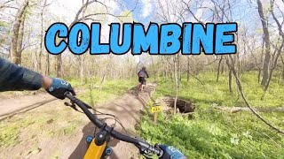
trail: Columbine
7:27 |
473 |
Oct 2, 2023 , Olathe
Recent Trail Reports
| status | trail | date | condition | info | user |
|---|---|---|---|---|---|
| Columbine | Feb 22, 2026 @ 2:53pm (America/Indiana/Vincennes) Feb 22, 2026 | Variable | hunterm87 | ||
| Billy Goat | Feb 22, 2026 @ 2:53pm (America/Indiana/Vincennes) Feb 22, 2026 | Variable | hunterm87 | ||
| Red Oak Falls | Feb 22, 2026 @ 2:53pm (America/Indiana/Vincennes) Feb 22, 2026 | Variable | hunterm87 | ||
| Ringneck | Feb 22, 2026 @ 2:53pm (America/Indiana/Vincennes) Feb 22, 2026 | Variable | hunterm87 | ||
| Big Bull Creek Loop Extension | Dec 26, 2025 @ 9:48pm (America/Chicago) Dec 26, 2025 | Dry | DriggsZ | ||
| Columbine Bypass | Oct 22, 2025 @ 10:57am (America/Indiana/Vincennes) Oct 22, 2025 | Ideal | ShannonSue44 | ||
| Columbine Connector | Oct 22, 2025 @ 10:57am (America/Indiana/Vincennes) Oct 22, 2025 | Ideal | ShannonSue44 | ||
| Inner Hank | Sep 8, 2025 @ 7:17pm Sep 8, 2025 | Dry | KyleB90 | ||
| Kill Creek Trail North | Jun 19, 2025 @ 10:15am Jun 19, 2025 | Wet | cbouff | ||
| Scape Goat | May 5, 2025 @ 11:07am May 5, 2025 | Ideal | 1cabinboy |
Activity Feed
| username | action | type | title | date |
|---|---|---|---|---|
| kkremer1 | ridden | trail | activity #96466014 | Jun 7, 2026 @ 8:46am Jun 7, 2026 |
| JosephShinnMWaOyM | comment | trail | activity #93773192 | May 1, 2026 @ 5:22am May 1, 2026 |
| JWrightKC | wishlist | trail | activity #93156988 and 1 more | Apr 22, 2026 @ 10:17am Apr 22, 2026 |
| dmurray810 | update | trail | activity #92135935 | Apr 7, 2026 @ 12:43pm Apr 7, 2026 |
| KCTrailSheperd | update | trail | activity #91775730 | Apr 2, 2026 @ 12:08pm Apr 2, 2026 |
Recent Comments
| username | type | title | comment | date |
|---|---|---|---|---|
| trail | Great fucking flow. Trail builders have done a... | May 1, 2026 @ 5:22am May 1, 2026 | ||
| trail | this is a fun descent. when coming down, you... | Jul 9, 2025 @ 7:16am Jul 9, 2025 | ||
| report | Thanks for adding a trail report! UTC has... | Jun 20, 2025 @ 8:57am Jun 20, 2025 | ||
| report | Pa” | Sep 2, 2024 @ 11:05am Sep 2, 2024 | ||
| report | P | Sep 2, 2024 @ 11:03am Sep 2, 2024 |
Local Badges
-

Epic Mountain Bike Climb 2k2 awarded -

Climbing 10k Badge22 awarded -

Mountain Biking 100k Badge0 awarded -

Epic Ride Descent 2k2 awarded -

Descent 10k Badge22 awarded -

Descent 100k Badge0 awarded
Activity Type Stats
| activitytype | trails | distance | descent | descent distance | total vertical | rating | global rank | state rank | photos | reports | routes | activity logs |
|---|---|---|---|---|---|---|---|---|---|---|---|---|
| Mountain Bike | 52 | 40 miles | 2,264 ft | 15 miles | 269 ft | #3,203 | #1,099 | 37 | 130 | 2 | 12,270 | |
| E-Bike | 28 | 10 miles | 338 ft | 3 miles | 226 ft | #5,603 | #1,724 | 83 | 1 | 662 | ||
| Horse | 1 | 2,083 ft | 7 ft | 305 ft | 10 ft | 3 | ||||||
| Hike | 68 | 49 miles | 2,815 ft | 18 miles | 269 ft | #4,430 | #1,562 | 130 | 1 | 366 | ||
| Trail Running | 67 | 46 miles | 2,680 ft | 17 miles | 269 ft | #4,457 | #1,364 | 130 | 1 | 177 |
Frequently Asked Questions About Olathe
▼
What are the best places to ride in Olathe?
Olathe has 7 areas to explore for mountain biking. The top rated areas are:
▼
What are the highest rated mountain biking trails in Olathe?
The highest rated mountain biking trails in Olathe are:
- Columbine (4.5/5)
- Red Oak Falls (4.3/5)
- Columbine Bypass (4.3/5)
- Columbine Technical Loop (4.3/5)
- Ringneck (4.1/5)
▼
What is the best time of the year to ride in Olathe?
Based on activity log data, the most popular months to ride in Olathe are:
- July (96 activities)
- August (60 activities)
- September (55 activities)
▼
Where can I park to ride in Olathe?
There are 17 parking locations listed in Olathe. The most popular parking spots are: View all parking and trailhead locations on the map to plan your visit.
Activities
Trails
Points of Interest
- By todd
 Trailforks & contributors
 - Admins: UTC Central, UTC Master
- #17949 - 5,833 views
- olathe activity log | embed map of Olathe mountain bike trails | olathe mountain biking points of interest
Downloading of trail gps tracks in kml & gpx formats is enabled for Olathe.
You must login to download files.