close
-
Layers w
- Weather Layers
- Pro
- Pro
- Pro
- Pro
- Pro
- Pro
- More Layers
- Pro
- Pro
- Pro
- Pro
-
Upgrade to

3D
Trail Conditions
- Unknown
- Snow Groomed
- Snow Packed
- Snow Covered
- Snow Cover Partial
- Freeze/thaw Cycle
- Icy
- Prevalent Mud
- Wet
- Variable
- Ideal
- Dry
- Very Dry
Trail Flow (Ridden Direction)
Trailforks scans users ridelogs to determine the most popular direction each trail is ridden. A good flowing trail network will have most trails flowing in a single direction according to their intension.
The colour categories are based on what percentage of riders are riding a trail in its intended direction.
The colour categories are based on what percentage of riders are riding a trail in its intended direction.
- > 96%
- > 90%
- > 80%
- > 70%
- > 50%
- < 50%
- bi-directional trail
- no data
Trail Last Ridden
Trailforks scans ridelogs to determine the last time a trail was ridden.
- < 2 days
- < 1 week
- < 2 weeks
- < 1 month
- < 6 months
- > 6 months
Trail Ridden Direction
The intended direction a trail should be ridden.
- Downhill Only
- Downhill Primary
- Both Directions
- Uphill Primary
- Uphill Only
- One Direction
Contribute Details
Colors indicate trail is missing specified detail.
- Description
- Photos
- Description & Photos
- Videos
Trail Popularity ?
Trailforks scans ridelogs to determine which trails are ridden the most in the last 9 months.
Trails are compared with nearby trails in the same city region with a possible 25 colour shades.
Think of this as a heatmap, more rides = more kinetic energy = warmer colors.
- most popular
- popular
- less popular
- not popular
ATV/ORV/OHV Filter
Max Vehicle Width
inches
US Cell Coverage
Legend

Radar Time
Activity Recordings
Trailforks uses anonymized public activity data.
?
Activity Recordings
Trailforks uses anonymized public activity data.
?
Personal Heatmap
▶
Activity Types
all
/
none
▶
Options
2
Date range
month
–
Winter Trails
Warning
A routing network for winter maps does not exist. Selecting trails using the winter trails layer has been disabled.
Missing Trails
Most Popular
Least Popular
Trails are colored based on popularity. The more popular a trail is, the more red. Less popular trails trend towards green.
Jump Magnitude Heatmap
Heatmap of where riders jump on trails. Zoom in to see individual jumps, click circles to view jump details.
BC Backroad Status
![map legend]()
Service Road Atlas is a free to use, community-driven service for viewing and creating reports on the numerous back-country service roads around B.C. and Alberta.

Slope Aspect
Direction the slope faces
Trails Deemphasized
Trails are shown in grey.
Only show trails with no bike usage.
Suggested Layers
Based on selected activity type
Save the current map location and zoom level as your default home location whenever this page is loaded.
SaveRolling hills, fast thrills, no spills. Ride through the endless loops of rollers and berms on the pump track or practise your jumps and downhill expertise on the skills track. Be honest, how ready are you? The Omeo MTB trails will have 121kms of never ridden cross country trails with levels ranging from easy for beginners to advanced. We’ve been told that the hills the region are reminiscent of some in Europe. Test out your on-road skills on the back-roads of Omeo.
Activities Click to view
- Mountain Bike
53 trails
- E-Bike
53 trails
- Gravel Bike
1 trails
- Adaptive Bike
3 trails
- Hike
5 trails
- Trail Running
4 trails
Region Details
- 1
- 1
- 8
- 21
- 5
- 1
Region Status
Caution as of Jul 7, 2026Stats
- Avg Trail Rating
- Trails (view details)
- 53
- Trails Mountain Bike
- 53
- Trails E-Bike
- 53
- Trails Gravel Bike
- 1
- Trails Adaptive Bike
- 3
- Trails Winter Fat Bike
- 1
- Trails Hike
- 5
- Trails Trail Running
- 4
- Total Distance
- 65 miles
- Total Descent Distance
- 32 miles
- Total Descent
- 16,839 ft
- Total Vertical
- 1,911 ft
- Highest Trailhead
- 3,960 ft
- Reports
- 639
- Photos
- 80
- Ridden Counter
- 11,605
Sub Regions
-
Omeo Mountain Bike Park
- 1
- 8
- 21
- 5
- 1
Popular Omeo Mountain Biking Trails
• 100 ★ 5.0 • 1,604 ft • 13 ft • 509 •
Popular easy / intermediate difficulty family friendly singletrack. This mountain bike primary trail and has a easy overall physical rating with a 13 ft green climb. It features berm and bridge. Trail visibility is always easy to follow. On average it takes 2 minutes to complete this trail.
• 95 ★ 4.7 • 4 miles • 205 ft • 463 •
Highly rated popular blue difficulty machine groomed. This mountain bike primary trail can be used downhill only and has a moderate overall physical rating with a 205 ft blue climb. It features berm, bridge, jump and gap jump. Exposure: High Risk of Serious Injury. Trail visibility is always easy to follow. On average it takes 2 minutes to complete this trail.
• 100 ★ 3.8 • 2,444 ft • 137 ft • 437 •
Popular easy / intermediate difficulty singletrack. This mountain bike primary trail.
• 95 ★ 4.5 • 1,220 ft • 0 ft • 416 •
Fair dinkum air time, this is a serious jumps trails for experienced riders. Watch others and get familiar with the jumps before trying, or don’t even think about it.
• 100 ★ 4.8 • 1,713 ft • 156 ft • 412 •
Popular easy / intermediate difficulty family friendly singletrack. This mountain bike primary trail and has a easy overall physical rating with a 156 ft green climb. Trail visibility is always easy to follow. On average it takes 3 minutes to complete this trail.
• 85 ★ 5.0 • 3,707 ft • 73 ft • 322 •
This fun short traverse links the Sam Hill trails with the Mt Mesley trails, some optional jumps will keep you on your toes!
• 90 ★ 4.4 • 1 mile • 35 ft • 319 •
No warm up here, it's right in to big berms with some option rocky A-lines and roller jumps as you make your way to .
• 95 ★ 4.0 • 1,932 ft • 35 ft • 315 •
A great way to get started for beginners and a good warm up for those planning to go further. Connects with for a nice introductory loop.
Omeo Mountain Bike Routes
6 miles • 1,357 ft • 4 •
This is a fun little loop taking in Billy Goat, to the lower gravity hub and down !
8 miles • 812 ft • 9 • Point to Point •
Omeo MTB Park Easy Gravity #2 Once you tackle the descent then take on in to !
4 miles • 444 ft • 5 • Loop •
This route takes you out to the Oriental Claims and back to the main trail head in town! A great...
7 miles • 754 ft • 7 •
Starting at the Big Gum Junction this is our easiest descent from the top, avoiding the...
3 miles • 297 ft • 2 • Loop •
If you have tackled the groms loop #1 then do it again and add in and turning it in to a 7km loop!
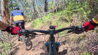
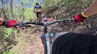
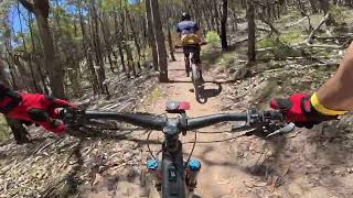
Photos of Omeo Mountain Bike
Videos of Omeo Mountain Bike

trail: Bangarang
7:35 |
197 |
Jan 22, 2026 , Omeo

trail: Beef Cheeks
3:29 |
39 |
Jan 6, 2026 , Omeo
trail: Bunyip
4:30 |
47 |
Jan 6, 2026 , Omeo

trail: Crikey
6:29 |
52 |
Jan 6, 2026 , Omeo

trail: Bangers N Thrash
5:08 |
40 |
Jan 6, 2026 , Omeo
trail: Darkside
6:54 |
33 |
Jan 6, 2026 , Omeo
trail: Muster
5:13 |
51 |
Jan 6, 2026 , Omeo

trail: Shotgun Alley
8:14 |
40 |
Jan 6, 2026 , Omeo
Current Trail Warnings
| status | trail | date | condition | user | info |
|---|---|---|---|---|---|
| Flomeo | Jun 29, 2026 @ 9:13am (Australia/Melbourne) Jun 28, 2026 | Unknown | Omeomtbtrailcrew | The Top section of Flomeo is currently... | |
| Pendulum | Jun 29, 2026 @ 9:13am (Australia/Melbourne) Jun 28, 2026 | Unknown | Omeomtbtrailcrew | The Top section of Flomeo is currently... | |
| Rowdy | Jun 29, 2026 @ 9:13am (Australia/Melbourne) Jun 28, 2026 | Unknown | Omeomtbtrailcrew | The Top section of Flomeo is currently... |
Recent Trail Reports
| status | trail | date | condition | info | user |
|---|---|---|---|---|---|
| Off Grid | Jul 8, 2026 @ 4:55pm (Australia/Melbourne) Jul 7, 2026 | Ideal | Stevezm2EH8 | ||
| Blue Roo | Jul 8, 2026 @ 4:49pm (Australia/Melbourne) Jul 7, 2026 | Unknown | Stevezm2EH8 | ||
| Bangarang | Jun 19, 2026 @ 7:13am (Australia/Melbourne) Jun 18, 2026 | Unknown | benreevesegipps OMEO | ||
| Rodeo | Jun 15, 2026 @ 11:53am (Australia/Melbourne) Jun 14, 2026 | Unknown | benreevesegipps OMEO | ||
| Crikey | Jun 15, 2026 @ 11:53am (Australia/Melbourne) Jun 14, 2026 | Unknown | benreevesegipps OMEO | ||
| Krank Dog | Jun 8, 2026 @ 1:09pm (Australia/Melbourne) Jun 7, 2026 | Unknown | NickhMFnce | ||
| Diggers Run | May 21, 2026 @ 7:38am (Australia/Melbourne) May 20, 2026 | Unknown | benreevesegipps OMEO | ||
| Dig Deep | May 21, 2026 @ 7:38am (Australia/Melbourne) May 20, 2026 | Unknown | benreevesegipps OMEO | ||
| Billygoat | May 14, 2026 @ 2:02pm (Australia/Melbourne) May 13, 2026 | Ideal | Kitesurfjim | ||
| Bangers N Thrash | May 5, 2026 @ 8:49am (Australia/Melbourne) May 4, 2026 | Ideal | benreevesegipps OMEO |
Activity Feed
| username | action | type | title | date |
|---|---|---|---|---|
| Stevezm2EH8 | add | report | activity #98694146 and 1 more | Jul 7, 2026 @ 11:49pm Jul 7, 2026 |
| JayWedb9q | ridden | trail | activity #98680009 | Jul 7, 2026 @ 5:58pm Jul 7, 2026 |
| Omeomtbtrailcrew | add | report | activity #98032341 and 2 more | Jun 28, 2026 @ 4:17pm Jun 28, 2026 |
| benreevesegipps | add | report | activity #98032177 | Jun 28, 2026 @ 4:14pm Jun 28, 2026 |
| Andyrowe247 | wishlist | region | activity #97534727 | Jun 21, 2026 @ 5:52pm Jun 21, 2026 |
Recent Comments
| username | type | title | comment | date |
|---|---|---|---|---|
| report | Tree over track. Maybe 3km from Mt Sam tower. | Jun 7, 2026 @ 8:08pm Jun 7, 2026 | ||
| trail | Easily one of the best trails in Omeo | Apr 3, 2026 @ 9:51pm Apr 3, 2026 | ||
| report | barely passable….two trips for me to get... | Apr 1, 2026 @ 8:54pm Apr 1, 2026 | ||
| trail | Rode to trail head. Sign saying closed and to... | Dec 8, 2025 @ 4:50pm Dec 8, 2025 | ||
| trail | To the sad sack who felt it was necessary to... | Dec 4, 2025 @ 2:22am Dec 4, 2025 |
Local Badges
-

Epic Mountain Bike Climb 2k28 awarded -

Climbing 10k Badge2 awarded -

Mountain Biking 100k Badge0 awarded -

Epic Ride Descent 2k28 awarded -

Descent 10k Badge6 awarded -

Descent 100k Badge1 awarded
Bike & Skill Parks
| name | type | city | rating |
|---|---|---|---|
| Omeo Mountain Bike Park | bike park | Omeo | |
| Omeo Pump Track and Skills Park | skill park | Omeo |
Activity Type Stats
| activitytype | trails | distance | descent | descent distance | total vertical | rating | global rank | state rank | photos | reports | routes | ridelogs |
|---|---|---|---|---|---|---|---|---|---|---|---|---|
| Mountain Bike | 53 | 65 miles | 16,837 ft | 32 miles | 1,909 ft | #1,718 | #86 | 80 | 639 | 14 | 2,336 | |
| E-Bike | 53 | 65 miles | 16,837 ft | 32 miles | 1,909 ft | #1,525 | #89 | 639 | 1 | 852 | ||
| Gravel Bike | 1 | #313 | #101 | 9 | 3 | 7 | ||||||
| Adaptive Bike | 3 | 3,409 ft | 7 ft | 476 ft | 105 ft | #272 | #151 | 13 | ||||
| Winter Fat Bike | 1 | 2 | ||||||||||
| Hike | 5 | 3 miles | 354 ft | 1 mile | 217 ft | #7,239 | #225 | 76 | 45 | |||
| Trail Running | 4 | 3 miles | 207 ft | 4,892 ft | 217 ft | #6,673 | #213 | 64 | 80 |
Frequently Asked Questions About Omeo
▼
What are the best places to ride in Omeo?
Omeo has 1 areas to explore for mountain biking. The top rated areas are:
▼
What are the highest rated mountain biking trails in Omeo?
The highest rated mountain biking trails in Omeo are:
- Flomeo (4.5/5)
- Diggers Run (4.4/5)
- Rodeo (4.3/5)
- Geddy Up (4.3/5)
- Crikey (4.3/5)
▼
What is the best time of the year to ride in Omeo?
Based on ride log data, the most popular months to ride in Omeo are:
- November (3 activities)
▼
Where can I park to ride in Omeo?
Trails
Points of Interest
- Emergency Marker: OMP100 Pump Track Information
- OMP205 Information
- OMP200 Information
- Sam Hill Summit
- Pioneer Lookout Viewpoint
- Emergency Marker: OMP150 Information
- Emergency Marker: OMP155 Information
- Emergency Marker: OMP190 Information
- Emergency Marker: OMP175 Information
- Emergency Marker: OMP110 - Oriental Claims Carpark Information
- Mount Phipps (1,549 m)
- Mount Bindi (1,495 m)
- Mount Nugong (1,483 m)
- By djpmtb
 & contributors
 - Admins: Victoria, Gmtb, MTBEG
- #41780 - 10,607 views
- omeo activity log | embed map of Omeo mountain bike trails | omeo mountain biking points of interest
Downloading of trail gps tracks in kml & gpx formats is enabled for Omeo.
You must login to download files.