close
-
Layers w
- Map Content
- More Layers
- Pro
- Pro
- Pro
- Pro
- Pro
- Pro
- Pro
- Pro
-
Upgrade to

3D
Trail Conditions
- Unknown
- Snow Groomed
- Snow Packed
- Snow Covered
- Snow Cover Partial
- Freeze/thaw Cycle
- Icy
- Prevalent Mud
- Wet
- Variable
- Ideal
- Dry
- Very Dry
Trail Flow (Ridden Direction)
Trailforks scans users ridelogs to determine the most popular direction each trail is ridden. A good flowing trail network will have most trails flowing in a single direction according to their intension.
The colour categories are based on what percentage of riders are riding a trail in its intended direction.
The colour categories are based on what percentage of riders are riding a trail in its intended direction.
- > 96%
- > 90%
- > 80%
- > 70%
- > 50%
- < 50%
- bi-directional trail
- no data
Trail Last Ridden
Trailforks scans ridelogs to determine the last time a trail was ridden.
- < 2 days
- < 1 week
- < 2 weeks
- < 1 month
- < 6 months
- > 6 months
Trail Ridden Direction
The intended direction a trail should be ridden.
- Downhill Only
- Downhill Primary
- Both Directions
- Uphill Primary
- Uphill Only
- One Direction
Contribute Details
Colors indicate trail is missing specified detail.
- Description
- Photos
- Description & Photos
- Videos
Trail Popularity ?
Trailforks scans ridelogs to determine which trails are ridden the most in the last 9 months.
Trails are compared with nearby trails in the same city region with a possible 25 colour shades.
Think of this as a heatmap, more rides = more kinetic energy = warmer colors.
- most popular
- popular
- less popular
- not popular
ATV/ORV/OHV Filter
Max Vehicle Width
inches
US Cell Coverage
Legend

Radar Time
x
Activity Recordings
Trailforks users anonymized public ridelogs from the past 6 months.
- mountain biking recent
- mountain biking (>6 month)
- hiking (1 year)
- moto (1 year)
Activity Recordings
Trailforks users anonymized public skilogs from the past 12 months.
- Downhill Ski
- Backcountry Ski
- Nordic Ski
- Snowmobile
Winter Trails
Warning
A routing network for winter maps does not exist. Selecting trails using the winter trails layer has been disabled.
x
Missing Trails
Most Popular
Least Popular
Trails are colored based on popularity. The more popular a trail is, the more red. Less popular trails trend towards green.
Jump Magnitude Heatmap
Heatmap of where riders jump on trails. Zoom in to see individual jumps, click circles to view jump details.
Trails Deemphasized
Trails are shown in grey.
Only show trails with NO bikes.
Save the current map location and zoom level as your default home location whenever this page is loaded.
SaveParco Farneto whose name derives from farnus, a species of oak, is the largest green lung in the city with 915,400 square meters. surface, which overlooks the district of San Giovanni and extends from San Luigi to Melara to the Rio Farneto which flows into the Longera valley.
Destroyed largely during the Second World War due to the need of the population to obtain firewood, the Boschetto was always public and from 1533 onwards the Austrian sovereigns who maintained it and had it fenced to prevent its devastation. Maria Teresa of Austria, around 1750, appointed a forester hunter for whom she built two houses, one in the middle of the hill and the other on the top, from which the toponym still in existence for that area of the city called the Hunter. In 1785 the forest owned 32,984 oaks that protected the city from the bora wind and made the air particularly healthy. Despite the wars, Sunday trips to the forest became a custom for Trieste people, especially after the walk in Viale XX Settembre was opened in 1808.
In 1858 the Ferdinandeo building was erected, then as a hotel with restaurant, cafeteria and ballroom. Parco Farneto was reopened to the public in 2000 after the restructuring and recovery of the historic paths which were partly paved and along which rest areas were created. The area also has a nature trail to observe the families of roe deer and other animals, a fitness trail for practicing gymnastic activities, a playground for children, for table tennis and bocce.
The park, well served by public transport, can be enjoyed in all its extension by walking it through the paths, but for those who do not want to give up the car there are two parking areas available with access from via Marchesetti.
source: ...
Primary Trail Type: Cross-Country
Land Status: Municipal Park
Land Manager: Comune di Trieste
 google parking directions
This region uses the Uk/Euro style trail grading system.
Activities Click to view
- Hike
17 trails
- Mountain Bike
18 trails
- E-Bike
13 trails
- Trail Running
16 trails
- Observed Trials
0 trails
Region Details
- 6
- 9
- 2
- 1
Region Status
Caution as of May 10, 2024Stats
- Avg Trail Rating
- Trails (view details)
- 18
- Trails Mountain Bike
- 18
- Trails E-Bike
- 13
- Trails Horse
- 1
- Trails Hike
- 17
- Trails Trail Running
- 16
- Total Distance
- 8 miles
- Total Descent
- 2,196 ft
- Total Vertical
- 985 ft
- Highest Trailhead
- 1,207 ft
- Reports
- 348
- Photos
- 20
- Ridden Counter
- 492
Popular Parco del Farneto Mountain Biking Trails
Photos of Parco del Farneto Mountain Bike
trail: No Briglie
20 |
Jul 26, 2021 @ 5:43am
Jul 26, 2021
trail: No Briglie
31 |
Jul 26, 2021 @ 5:43am
Jul 26, 2021
trail: La Cresta di Riposo
47 |
Mar 24, 2021 @ 8:41am
Mar 24, 2021
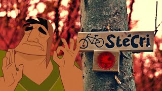
trail: StéCri
100 |
Feb 2, 2021 @ 1:33pm
Feb 2, 2021
trail: StéCri
116 |
Feb 2, 2021 @ 1:33pm
Feb 2, 2021
trail: StéCri
101 |
Feb 2, 2021 @ 1:33pm
Feb 2, 2021Videos of Parco del Farneto Mountain Bike

trail: Lubis36
4:15 |
7 |
Apr 15, 2024 , Trieste
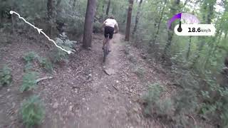
trail: StéCri
4:47 |
408 |
Apr 17, 2021 , Trieste

trail: La Casa delle Streghe 2.0
5:31 |
181 |
Apr 5, 2021 , Trieste

6:37 |
277 |
Jun 11, 2020 , Trieste

6:29 |
220 |
May 21, 2020 , Trieste

trail: Boschetto DH
6:25 |
343 |
Jan 19, 2020 , Trieste

trail: Boschetto DH
2:22 |
230 |
Jan 19, 2020 , Trieste
trail: Sentiero dele Scole
3:08 |
300 |
Jul 18, 2019 , Trieste
Recent Trail Reports
| status | trail | date | condition | info | user |
|---|---|---|---|---|---|
| Singletrack Ferdinandeo lower part | May 10, 2024 @ 2:42am May 10, 2024 | Ideal | AlfonsoTraverso | ||
| Ferdinandeo singletrack upper part | Apr 28, 2024 @ 2:35am Apr 28, 2024 | Ideal | AlfonsoTraverso | ||
| Link Monkey - Climb Way | Apr 28, 2024 @ 2:35am Apr 28, 2024 | Ideal | AlfonsoTraverso | ||
| El Porco scondido 3.0 | Apr 28, 2024 @ 2:35am Apr 28, 2024 | Ideal | AlfonsoTraverso | ||
| Walk/cycle way beyond the guard rail | Apr 21, 2024 @ 7:26am Apr 21, 2024 | Dry | AlfonsoTraverso | ||
| Sentiero dele Scole | Apr 21, 2024 @ 7:26am Apr 21, 2024 | Wet | AlfonsoTraverso | ||
| Boschetto DH | Feb 1, 2024 @ 6:06am Feb 1, 2024 | Variable | Relox | ||
| StéCri | Dec 20, 2023 @ 6:40am Dec 20, 2023 | Variable | medioman69 | ||
| le briglie | Nov 5, 2023 @ 9:29am Nov 5, 2023 | Wet | AlenFIArGZ | ||
| La Casa delle Streghe 2.0 | Oct 28, 2023 @ 1:05pm Oct 28, 2023 | Wet | AlenFIArGZ |
Activity Feed
| username | action | type | title | date |
|---|---|---|---|---|
| AlfonsoTraverso | add | report | activity #52374919 | May 10, 2024 @ 10:37am May 10, 2024 |
| AlfonsoTraverso | add | report | activity #51797369 and 3 more | Apr 28, 2024 @ 8:15am Apr 28, 2024 |
| AlfonsoTraverso | add | report | activity #51711516 and 3 more | Apr 26, 2024 @ 8:16am Apr 26, 2024 |
| Magarita | wishlist | region | activity #51635038 | Apr 24, 2024 @ 12:11pm Apr 24, 2024 |
| WernerAfd1C5 | wishlist | trail | activity #51496723 | Apr 21, 2024 @ 12:41pm Apr 21, 2024 |
Recent Comments
| username | type | title | comment | date |
|---|---|---|---|---|
| trail | This Is not a Red Trail. Still a bit rough and... | Mar 9, 2021 @ 11:21am Mar 9, 2021 | ||
| trail | The trail needs to be worked because there are... | Apr 21, 2020 @ 8:49am Apr 21, 2020 | ||
| trail | very nice! | May 25, 2018 @ 1:45am May 25, 2018 |
Nearby Areas
| name | distance | ||||
|---|---|---|---|---|---|
| 3 Camini - Cascatelle | 5 | 4 | 1.4 km | ||
| Basovìzza - Bazovica | 75 | 6 | 2.6 km | ||
| Bagnoli-Dolina | 8 | 5 | 3.4 km | ||
| Opicina - Opčine | 49 | 4 | 3.7 km | ||
| Sežana | 32 | 10 | 5.1 km |
Local Badges
-

Completionist0 awarded
Activity Type Stats
| activitytype | trails | distance | descent | descent distance | total vertical | rating | global rank | state rank | photos | reports | routes | ridelogs |
|---|---|---|---|---|---|---|---|---|---|---|---|---|
| Mountain Bike | 18 | 8 miles | 2,195 ft | 4 miles | 984 ft | #7,235 | #365 | 20 | 348 | 1,082 | ||
| E-Bike | 13 | 6 miles | 1,316 ft | 2 miles | 955 ft | #3,395 | #322 | 313 | 180 | |||
| Horse | 1 | 653 ft | 89 ft | 3 ft | 4 | |||||||
| Hike | 17 | 8 miles | 2,192 ft | 4 miles | 984 ft | #6,264 | #300 | 346 | 7 | |||
| Trail Running | 16 | 8 miles | 1,926 ft | 4 miles | 984 ft | #6,358 | #296 | 339 | 17 |
- By julian-mtb
 & contributors
 - Admins: TMTBT, julian-mtb
- #38187 - 1,829 views
- parco del farneto activity log | embed map of Parco del Farneto mountain bike trails | parco del farneto mountain biking points of interest
Downloading of trail gps tracks in kml & gpx formats is enabled for Parco del Farneto.
You must login to download files.