close
-
Layers w
- Map Content
- More Layers
- Pro
- Pro
- Pro
- Pro
- Pro
- Pro
- Pro
- Pro
-
Upgrade to

3D
Trail Conditions
- Unknown
- Snow Groomed
- Snow Packed
- Snow Covered
- Snow Cover Partial
- Freeze/thaw Cycle
- Icy
- Prevalent Mud
- Wet
- Variable
- Ideal
- Dry
- Very Dry
Trail Flow (Ridden Direction)
Trailforks scans users ridelogs to determine the most popular direction each trail is ridden. A good flowing trail network will have most trails flowing in a single direction according to their intension.
The colour categories are based on what percentage of riders are riding a trail in its intended direction.
The colour categories are based on what percentage of riders are riding a trail in its intended direction.
- > 96%
- > 90%
- > 80%
- > 70%
- > 50%
- < 50%
- bi-directional trail
- no data
Trail Last Ridden
Trailforks scans ridelogs to determine the last time a trail was ridden.
- < 2 days
- < 1 week
- < 2 weeks
- < 1 month
- < 6 months
- > 6 months
Trail Ridden Direction
The intended direction a trail should be ridden.
- Downhill Only
- Downhill Primary
- Both Directions
- Uphill Primary
- Uphill Only
- One Direction
Contribute Details
Colors indicate trail is missing specified detail.
- Description
- Photos
- Description & Photos
- Videos
Trail Popularity ?
Trailforks scans ridelogs to determine which trails are ridden the most in the last 9 months.
Trails are compared with nearby trails in the same city region with a possible 25 colour shades.
Think of this as a heatmap, more rides = more kinetic energy = warmer colors.
- most popular
- popular
- less popular
- not popular
ATV/ORV/OHV Filter
Max Vehicle Width
inches
US Cell Coverage
Legend

Radar Time
x
Activity Recordings
Trailforks users anonymized public ridelogs from the past 6 months.
- mountain biking recent
- mountain biking (>6 month)
- hiking (1 year)
- moto (1 year)
Activity Recordings
Trailforks users anonymized public skilogs from the past 12 months.
- Downhill Ski
- Backcountry Ski
- Nordic Ski
- Snowmobile
Winter Trails
Warning
A routing network for winter maps does not exist. Selecting trails using the winter trails layer has been disabled.
x
Missing Trails
Most Popular
Least Popular
Trails are colored based on popularity. The more popular a trail is, the more red. Less popular trails trend towards green.
Jump Magnitude Heatmap
Heatmap of where riders jump on trails. Zoom in to see individual jumps, click circles to view jump details.
Trails Deemphasized
Trails are shown in grey.
Only show trails with NO bikes.
Save the current map location and zoom level as your default home location whenever this page is loaded.
Save
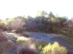
No description for Powerline has been added yet!
Login or register to submit one.
 google parking directions
Primary Trail Type: Cross-Country
Land Status: National Forest
Land Manager: USFS Lake Tahoe Basin Management Unit
google parking directions Activities Click to view
- Mountain Bike
10 trails
- E-Bike
2 trails
- Hike
10 trails
- Trail Running
10 trails
Region Details
- 2
- 4
- 3
- 1
Region Status
Open as of May 13, 2024Stats
- Avg Trail Rating
- Trails (view details)
- 10
- Trails Mountain Bike
- 10
- Trails E-Bike
- 2
- Trails Horse
- 10
- Trails Hike
- 10
- Trails Trail Running
- 10
- Trails Dirtbike/Moto
- 1
- Trails ATV/ORV/OHV
- 1
- Total Distance
- 14 miles
- Total Descent
- 1,811 ft
- Total Vertical
- 1,549 ft
- Highest Trailhead
- 7,844 ft
- Reports
- 186
- Photos
- 81
- Ridden Counter
- 1,447
Popular Powerline Mountain Biking Trails
Powerline Mountain Bike Routes
| title | rating | distance |
|---|---|---|
| Star Freel Peak Armstrong loop | 22 miles |
Photos of Powerline Mountain Bike
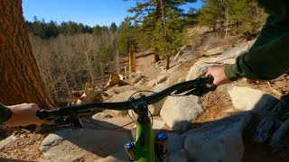
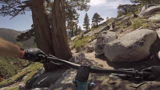
trail: Powerline Trail
11 |
Sep 30, 2023 @ 2:23pm
Sep 30, 2023
trail: Al Tahoe Connector
7 |
Jun 27, 2023 @ 7:12pm
Jun 27, 2023
trail: Powerline Trail
38 |
Jun 27, 2023 @ 7:12pm
Jun 27, 2023
trail: Powerline Trail
41 |
Jun 27, 2023 @ 7:12pm
Jun 27, 2023
trail: Powerline Trail
37 |
Jun 27, 2023 @ 7:11pm
Jun 27, 2023
trail: Powerline Trail
34 |
Jun 27, 2023 @ 7:11pm
Jun 27, 2023
trail: Columbine Trail Connector
30 |
Jul 12, 2022 @ 3:03pm
Jul 12, 2022
trail: High Meadows Road
62 |
Aug 1, 2021 @ 10:16pm
Aug 1, 2021Videos of Powerline Mountain Bike

trail: High Meadows OHV Trail
3:21 |
447 |
Mar 4, 2012

trail: Cold Creek Trail (Upper)
12:52 |
316 |
Jul 11, 2022 , South Lake Tahoe
trail: Powerline Trail
0:17 |
511 |
Nov 14, 2009
trail: Cold Creek Trail (Lower)
10:40 |
147 |
Nov 29, 2021 , South Lake Tahoe

trail: Cold Creek Trail (Upper)
4:53 |
224 |
Jul 6, 2021 , South Lake Tahoe

trail: Cold Creek Trail (Upper)
20:42 |
590 |
Jul 6, 2020 , South Lake Tahoe

trail: Cold Creek Trail (Lower)
13:22 |
276 |
Sep 15, 2019 , South Lake Tahoe
trail: Cold Creek Trail (Upper)
13:22 |
379 |
Sep 15, 2019 , South Lake Tahoe
Recent Trail Reports
| status | trail | date | condition | info | user |
|---|---|---|---|---|---|
| Al Tahoe Connector | May 13, 2024 @ 9:08am May 13, 2024 | Dry | Westigirl79 | ||
| Cold Creek Trail (Lower) | Apr 28, 2024 @ 4:34pm Apr 28, 2024 | Variable | agar390 | ||
| Powerline/Cold Creek Connector | Apr 27, 2024 @ 2:30pm Apr 27, 2024 | Dry | alanISdDrI | ||
| High Meadows Road | Aug 23, 2023 @ 8:09am Aug 23, 2023 | Ideal | DWCTHC | ||
| Powerline Trail | Jul 22, 2023 @ 11:08pm Jul 22, 2023 | Dry | loam-ranger308 RVMBA | ||
| Cold Creek Trail (Upper) | Jul 23, 2023 @ 12:21am Jul 23, 2023 | Dry | loam-ranger308 RVMBA | ||
| Cold Creek Upper Connector | Jun 20, 2023 @ 11:42pm Jun 20, 2023 | Wet | sfbaysam | ||
| Columbine Trail Connector | May 26, 2023 @ 9:18am May 26, 2023 | Dry | tambadrew TAMBA | ||
| High Meadows OHV Trail | Jun 11, 2022 @ 3:50pm Jun 11, 2022 | Very Dry | scott-ws | ||
| Cold Creek Access Road | Jul 6, 2021 @ 8:13am Jul 6, 2021 | Ideal | amidroc |
Activity Feed
| username | action | type | title | date |
|---|---|---|---|---|
| Coryeja4Cl | ridden | trail | activity #52699887 and 5 more | May 16, 2024 @ 4:38pm 3 days |
| MarkGouldGec | wishlist | route | activity #52584083 | May 14, 2024 @ 6:30am May 14, 2024 |
| CAQSeL3k | wishlist | trail | activity #52574908 | May 13, 2024 @ 10:36pm May 13, 2024 |
| Westigirl79 | add | report | activity #52544328 | May 13, 2024 @ 9:08am May 13, 2024 |
| robeicher | wishlist | trail | activity #52340288 | May 9, 2024 @ 5:44pm May 9, 2024 |
Recent Comments
| username | type | title | comment | date |
|---|---|---|---|---|
| trail | Whoever keeps cutting B-Lines in the trail... | Jul 2, 2022 @ 1:41am Jul 2, 2022 | ||
| trail | Unpleasant is the perfect word for this road | Jul 22, 2021 @ 2:17pm Jul 22, 2021 | ||
| trail | May 5,2021 good to go up to high meadows. | May 6, 2021 @ 6:43pm May 6, 2021 | ||
| trail | This is a pretty brutal climb! | Jun 27, 2020 @ 12:59am Jun 27, 2020 | ||
| trail | A short green trail. | Apr 22, 2020 @ 11:13pm Apr 22, 2020 |
Nearby Areas
| name | distance | ||||
|---|---|---|---|---|---|
| SLT Urban Trails | 22 | 1 | 1.6 km | ||
| Hartoonian Trails | 27 | 1.8 km | |||
| Corral | 3 | 4 | 2 | 2.2 km | |
| Freel High Country | 5 | 5 | 3.4 km | ||
| Van Sickle | 1 | 3 | 1 | 3.9 km |
Activity Type Stats
| activitytype | trails | distance | descent | descent distance | total vertical | rating | global rank | state rank | photos | reports | routes | ridelogs |
|---|---|---|---|---|---|---|---|---|---|---|---|---|
| Mountain Bike | 10 | 14 miles | 1,811 ft | 5 miles | 1,549 ft | #2,005 | #1,075 | 78 | 183 | 1 | 959 | |
| E-Bike | 2 | 4 miles | 374 ft | 1 mile | 1,394 ft | #1,422 | #404 | 128 | 1 | 145 | ||
| Horse | 10 | 14 miles | 1,811 ft | 5 miles | 1,549 ft | 124 | ||||||
| Hike | 10 | 14 miles | 1,811 ft | 5 miles | 1,549 ft | #1,549 | #948 | 3 | 183 | 3 | 94 | |
| Trail Running | 10 | 14 miles | 1,811 ft | 5 miles | 1,549 ft | #1,551 | #944 | 183 | 1 | 86 | ||
| Dirtbike/Moto | 1 | 4,285 ft | 197 ft | 2,789 ft | 164 ft | 86 | ||||||
| ATV/ORV/OHV | 1 | 4,285 ft | 197 ft | 2,789 ft | 164 ft | 86 |
- By TheAngryTomato
 TRAILFORKS & contributors
 - Admins: TAMBA, TRTA
- #46663 - 1,121 views
- powerline activity log | embed map of Powerline mountain bike trails | powerline mountain biking points of interest
Downloading of trail gps tracks in kml & gpx formats is enabled for Powerline.
You must login to download files.