close
-
Layers w
- Weather Layers
- Pro
- Pro
- Pro
- Pro
- Pro
- Pro
- More Layers
- Pro
- Pro
- Pro
- Pro
-
Upgrade to

3D
Trail Conditions
- Unknown
- Snow Groomed
- Snow Packed
- Snow Covered
- Snow Cover Partial
- Freeze/thaw Cycle
- Icy
- Prevalent Mud
- Wet
- Variable
- Ideal
- Dry
- Very Dry
Trail Flow (Ridden Direction)
Trailforks scans users ridelogs to determine the most popular direction each trail is ridden. A good flowing trail network will have most trails flowing in a single direction according to their intension.
The colour categories are based on what percentage of riders are riding a trail in its intended direction.
The colour categories are based on what percentage of riders are riding a trail in its intended direction.
- > 96%
- > 90%
- > 80%
- > 70%
- > 50%
- < 50%
- bi-directional trail
- no data
Trail Last Ridden
Trailforks scans ridelogs to determine the last time a trail was ridden.
- < 2 days
- < 1 week
- < 2 weeks
- < 1 month
- < 6 months
- > 6 months
Trail Ridden Direction
The intended direction a trail should be ridden.
- Downhill Only
- Downhill Primary
- Both Directions
- Uphill Primary
- Uphill Only
- One Direction
Contribute Details
Colors indicate trail is missing specified detail.
- Description
- Photos
- Description & Photos
- Videos
Trail Popularity ?
Trailforks scans ridelogs to determine which trails are ridden the most in the last 9 months.
Trails are compared with nearby trails in the same city region with a possible 25 colour shades.
Think of this as a heatmap, more rides = more kinetic energy = warmer colors.
- most popular
- popular
- less popular
- not popular
ATV/ORV/OHV Filter
Max Vehicle Width
inches
US Cell Coverage
Legend

Radar Time
Activity Recordings
Trailforks uses anonymized public activity data.
?
Activity Recordings
Trailforks uses anonymized public activity data.
?
Personal Heatmap
▶
Activity Types
all
/
none
▶
Options
2
Date range
month
–
Winter Trails
Warning
A routing network for winter maps does not exist. Selecting trails using the winter trails layer has been disabled.
Missing Trails
Most Popular
Least Popular
Trails are colored based on popularity. The more popular a trail is, the more red. Less popular trails trend towards green.
Jump Magnitude Heatmap
Heatmap of where riders jump on trails. Zoom in to see individual jumps, click circles to view jump details.
BC Backroad Status
![map legend]()
Service Road Atlas is a free to use, community-driven service for viewing and creating reports on the numerous back-country service roads around B.C. and Alberta.

Slope Aspect
Direction the slope faces
Trails Deemphasized
Trails are shown in grey.
Only show trails with no bike usage.
Suggested Layers
Based on selected activity type
Save the current map location and zoom level as your default home location whenever this page is loaded.
Save
No description for Prato has been added yet!
Login or register to submit one.
This region uses the Uk/Euro style trail grading system.
Activities Click to view
- Mountain Bike
149 trails
- E-Bike
42 trails
- Horse
7 trails
- Hike
135 trails
- Trail Running
135 trails
Region Details
- 35
- 39
- 46
- 1
Stats
- Avg Trail Rating
- Trails (view details)
- 138
- Trails Mountain Bike
- 151
- Trails E-Bike
- 42
- Trails Horse
- 7
- Trails Hike
- 135
- Trails Trail Running
- 135
- Trails Dirtbike/Moto
- 2
- Total Distance
- 88 miles
- Total Descent
- 34,303 ft
- Total Vertical
- 3,302 ft
- Highest Trailhead
- 3,492 ft
- Reports
- 2,009
- Photos
- 112
- Ridden Counter
- 9,224
Sub Regions
- Montemurlo (87)
- Monte Javello (47)
- Prato (36)
- Vainella (13)
Popular Prato Mountain Biking Trails
• 90 ★ 4.6 • 4,760 ft • 21 ft • 213 •
Highly rated popular green difficulty singletrack. This mountain bike primary trail can be used downhill primary. On average it takes 7 minutes to complete this trail.
• 90 ★ 4.8 • 1,878 ft • 11 ft • 207 •
Popular green difficulty singletrack. This mountain bike primary trail can be used downhill primary. It features jump. On average it takes 4 minutes to complete this trail.
• 95 ★ 0.0 • 886 ft • 84 ft • 194 •
Popular green difficulty singletrack. This mountain bike primary trail can be used downhill primary and has a easy overall physical rating with a 84 ft blue climb. It features log ride. Trail visibility is always easy to follow. On average it takes 2 minutes to complete this trail.
• 80 ★ 4.0 • 4,649 ft • 449 ft • 171 •
sentiero in salita per mtb,che permette di arrivare in cima al monte iavello e cavallaie,per raggiungere la partenza dei vari trails,in alcuni punti duro ma bello,lungo il sentiero sulla sx ,permette di ammirare una vecchia
• 95 ★ 4.0 • 1,033 ft • 39 ft • 170 •
Popular green difficulty singletrack. This mountain bike primary trail can be used both directions and has a easy overall physical rating with a 39 ft blue climb. It features log ride. Trail visibility is sometimes hard to follow. On average it takes 3 minutes to complete this trail.
• 70 ★ 5.0 • 2,347 ft • 15 ft • 160 •
Popular blue difficulty singletrack. This mountain bike primary trail can be used downhill primary. On average it takes 3 minutes to complete this trail.
• ★ 5.0 • 2,359 ft • 2 ft • 148 •
Green difficulty singletrack. This mountain bike primary trail can be used both directions and has a easy overall physical rating with a 2 ft blue climb. It features a-frame. Trail visibility is sometimes hard to follow. On average it takes 2 minutes to complete this trail.
• 50 ★ 4.0 • 4,042 ft • 0 ft • 135 •
Moderately popular blue difficulty singletrack. This mountain bike primary trail can be used downhill only. It features a-frame, berm, bridge, drop and jump. Trail visibility is always easy to follow. On average it takes 5 minutes to complete this trail.
Prato Mountain Bike Routes
★ 5.0 • 45 miles • 6,761 ft • 1 •
Trail impegnativo del crinale appenninico Pratese, circa 40 km di puro single track ininterrotto! Il trail...
★ 4.0 • 23 miles • 6,563 ft • 9 • Loop •
Classico Cannicciaie con l'aggiunta di qualche sentiero ancora da provare
19 miles • 3,771 ft • 2 •
Partenza da Sommaia, si sale per via di Baroncoli fino a morello, si prosegue per via di Gualdo fino alle...
★ 1.0 • 13 miles • 2,363 ft • 3 •
Si parte da Sommaia, salita della chiesa fino alla sbarra, primo trail Frogger parte alta, e poi si risale...
8 miles • 1,735 ft • 8 •
salita da vallupaia fino a poi discesa fino a figline passando per lilly ollie
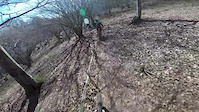
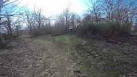
Photos of Prato Mountain Bike
Videos of Prato Mountain Bike
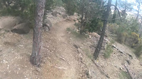
trail: HighWay
0:37 |
25 |
Apr 25, 2021
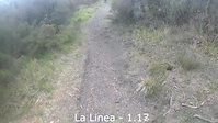
trail: La Linea Primo Settore
0:17 |
8 |
Apr 20, 2021
trail: Paline
5:06 |
53 |
Oct 20, 2017

trail: Lisca
4:55 |
94 |
Apr 24, 2017
trail: Lisca
6:32 |
89 |
Apr 3, 2017
trail: Lisca
5:07 |
38 |
Mar 21, 2017
trail: Lisca
5:54 |
97 |
Feb 28, 2017
trail: Carbonaie
8:23 |
109 |
Dec 10, 2016
Current Trail Warnings
| status | trail | date | condition | user | info |
|---|---|---|---|---|---|
| Prunaio Monte Javello | Jun 9, 2026 @ 3:13pm (Europe/Rome) Jun 9, 2026 | Dry | mattiamengoni | ||
| La Spola 1° Parte Monte Javello | Jun 9, 2026 @ 3:13pm (Europe/Rome) Jun 9, 2026 | Unknown | mattiamengoni | ||
| Javello Trail Monte Javello | May 25, 2026 @ 10:02am (Europe/Rome) May 25, 2026 | Ideal | Marcofanta | E-Bike completamente chiusa dalla vegetazione,... |
Recent Trail Reports
| status | trail | date | condition | info | user |
|---|---|---|---|---|---|
| Duca Trail Monte Javello | Jun 12, 2026 @ 12:21pm (Europe/Rome) Jun 12, 2026 | Ideal | mattiamengoni | ||
| Brain - VTC Vainella | Jun 4, 2026 @ 6:46pm (Europe/Rome) Jun 4, 2026 | Ideal | mattiamengoni | ||
| Botox Monte Javello | Jun 4, 2026 @ 6:44pm (Europe/Rome) Jun 4, 2026 | Ideal | mattiamengoni | ||
| Carbonaie Monte Javello | Jun 4, 2026 @ 6:43pm (Europe/Rome) Jun 4, 2026 | Ideal | mattiamengoni | ||
| Moana Prato | Jun 4, 2026 @ 6:43pm (Europe/Rome) Jun 4, 2026 | Dry | mattiamengoni | ||
| Access up 3 Prato | May 31, 2026 @ 9:11am (Europe/Rome) May 31, 2026 | Ideal | SP0304 | ||
| Rocca Monte Javello | May 31, 2026 @ 10:58am (Europe/San_Marino) May 31, 2026 | Ideal | Mark47 | ||
| cai 70 second part Monte Javello | May 31, 2026 @ 10:58am (Europe/San_Marino) May 31, 2026 | Dry | Mark47 | ||
| CAI 70 Monte Javello | May 31, 2026 @ 10:58am (Europe/San_Marino) May 31, 2026 | Dry | Mark47 | ||
| Rilanci Prato | May 24, 2026 @ 8:50am (Europe/Rome) May 23, 2026 | Ideal | bluca |
Activity Feed
| username | action | type | title | date |
|---|---|---|---|---|
| 7Geiko9XTZhh9 | wishlist | trail | activity #97243441 | Jun 18, 2026 @ 4:47am 1 day |
| mattiamengoni | add | report | activity #96792101 | Jun 12, 2026 @ 3:21am Jun 12, 2026 |
| mattiamengoni | add | report | activity #96600757 and 1 more | Jun 9, 2026 @ 6:13am Jun 9, 2026 |
| mattiamengoni | add | report | activity #96295405 | Jun 5, 2026 @ 7:46am Jun 5, 2026 |
| mattiamengoni | vote | trail | activity #96295397 | Jun 5, 2026 @ 7:46am Jun 5, 2026 |
Recent Comments
| username | type | title | comment | date |
|---|---|---|---|---|
| report | Confermo | Apr 15, 2026 @ 1:17am Apr 15, 2026 | ||
| report | Sentiero molto divertente | Jan 18, 2026 @ 7:15am Jan 18, 2026 | ||
| report | Molto divertente | Jan 18, 2026 @ 7:14am Jan 18, 2026 | ||
| report | Asciuga con fatica dopo la pioggia | Jan 16, 2026 @ 12:03pm Jan 16, 2026 | ||
| report | Il sentiero è stato ora messo in sicurezza | Oct 27, 2025 @ 2:02am Oct 27, 2025 |
Local Badges
-

Epic Ride 50k537 awarded -

Descent 10k Badge28 awarded -

Descent 100k Badge3 awarded -
Descent 100k Badge2 awarded -

Big Ride 30k918 awarded -

10 Green Trails94 awarded
Activity Type Stats
| activitytype | trails | distance | descent | descent distance | total vertical | rating | global rank | state rank | photos | reports | routes | ridelogs |
|---|---|---|---|---|---|---|---|---|---|---|---|---|
| Mountain Bike | 149 | 88 miles | 34,304 ft | 51 miles | 3,301 ft | 112 | 2,016 | 9 | 9,193 | |||
| E-Bike | 42 | 33 miles | 9,948 ft | 16 miles | 3,176 ft | 1,391 | 6 | 1,738 | ||||
| Horse | 7 | 3 miles | 745 ft | 1 mile | 1,194 ft | 16 | ||||||
| Hike | 135 | 75 miles | 27,756 ft | 43 miles | 3,301 ft | 1,871 | 243 | |||||
| Trail Running | 135 | 74 miles | 27,418 ft | 42 miles | 3,301 ft | 1,893 | 1 | 176 | ||||
| Dirtbike/Moto | 2 | 2 miles | 10 ft | 279 ft | 840 ft | 15 |
Frequently Asked Questions About Prato
▼
What are the best places to ride in Prato?
Prato has 2 areas to explore for mountain biking. The top rated areas are:
▼
What are the highest rated mountain biking trails in Prato?
▼
What is the best time of the year to ride in Prato?
Based on ride log data, the most popular months to ride in Prato are:
- November (46 activities)
- December (34 activities)
- June (24 activities)
▼
What is the longest trail in Prato?
The longest trail in Prato is Lupin at 2.6 miles. View all trails sorted by distance.
Activities
Trails
Points of Interest
- By denitopia
 TRAILFORKS VTA & contributors
 - Admins: denitopia, marcoangeletti, cemoorelife, DanielePracchia
- #11647 - 3,613 views
- prato activity log | embed map of Prato mountain bike trails | prato mountain biking points of interest
Downloading of trail gps tracks in kml & gpx formats is enabled for Prato.
You must login to download files.