close
-
Layers w
- Weather Layers
- Pro
- Pro
- Pro
- Pro
- Pro
- Pro
- More Layers
- Pro
- Pro
- Pro
- Pro
-
Upgrade to

3D
Trail Conditions
- Unknown
- Snow Groomed
- Snow Packed
- Snow Covered
- Snow Cover Partial
- Freeze/thaw Cycle
- Icy
- Prevalent Mud
- Wet
- Variable
- Ideal
- Dry
- Very Dry
Trail Flow (Ridden Direction)
Trailforks scans users ridelogs to determine the most popular direction each trail is ridden. A good flowing trail network will have most trails flowing in a single direction according to their intension.
The colour categories are based on what percentage of riders are riding a trail in its intended direction.
The colour categories are based on what percentage of riders are riding a trail in its intended direction.
- > 96%
- > 90%
- > 80%
- > 70%
- > 50%
- < 50%
- bi-directional trail
- no data
Trail Last Ridden
Trailforks scans ridelogs to determine the last time a trail was ridden.
- < 2 days
- < 1 week
- < 2 weeks
- < 1 month
- < 6 months
- > 6 months
Trail Ridden Direction
The intended direction a trail should be ridden.
- Downhill Only
- Downhill Primary
- Both Directions
- Uphill Primary
- Uphill Only
- One Direction
Contribute Details
Colors indicate trail is missing specified detail.
- Description
- Photos
- Description & Photos
- Videos
Trail Popularity ?
Trailforks scans ridelogs to determine which trails are ridden the most in the last 9 months.
Trails are compared with nearby trails in the same city region with a possible 25 colour shades.
Think of this as a heatmap, more rides = more kinetic energy = warmer colors.
- most popular
- popular
- less popular
- not popular
ATV/ORV/OHV Filter
Max Vehicle Width
inches
US Cell Coverage
Legend

Radar Time
Activity Recordings
Trailforks uses anonymized public activity data.
?
Activity Recordings
Trailforks uses anonymized public activity data.
?
Personal Heatmap
▶
Activity Types
all
/
none
▶
Options
2
Date range
month
–
Winter Trails
Warning
A routing network for winter maps does not exist. Selecting trails using the winter trails layer has been disabled.
Missing Trails
Most Popular
Least Popular
Trails are colored based on popularity. The more popular a trail is, the more red. Less popular trails trend towards green.
Jump Magnitude Heatmap
Heatmap of where riders jump on trails. Zoom in to see individual jumps, click circles to view jump details.
BC Backroad Status
![map legend]()
Service Road Atlas is a free to use, community-driven service for viewing and creating reports on the numerous back-country service roads around B.C. and Alberta.

Slope Aspect
Direction the slope faces
Trails Deemphasized
Trails are shown in grey.
Only show trails with no bike usage.
Suggested Layers
Based on selected activity type
Save the current map location and zoom level as your default home location whenever this page is loaded.
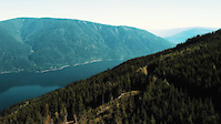
SaveThe Rubberhead started off as a single mountain bike trail in the late 1980's. Now the area offers a variety of downhill mountain bike options for intermediate to advance riders. From steep and rooty to open and flowy. The trail system is looked after by local trail stewards with the Shuswap Bike Club in collaboration with the Shuswap Trail Alliance. Planning of trails in the area is done in consultation with Canoe Forest Products who operate in the area.
The Main lower parking is at 2.5km on the 110 Forest Service Road (see access notes below). Here you will find parking and maps of the trail system. The Double D trail is the main climbing route from here. Down Hill trailheads range from 4 km to 11 km up the 110 FSR.
Connect to the Larch Hills and the Larch Hills Traverse: The Rubberhead Trail System connects to the Larch Hills trail system and the Larch Hills Traverse. They can be linked into a variety of epic cross-country rides linking over to the South Canoe Trails, as well as the Larch Hills Traverse to Sicamous. Or try the Reverse Traverse of the Larch Hills Traverse, which is to start in Sicamous and ride the LHT east to west, but ending with a flowy desent through the Rubberhead Trails back to Salmon Arm. Lots of opportunity to get creative
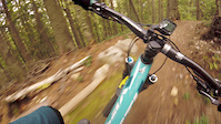
Primary Trail Type: All-Mountain & Downhill
eBikes Allowed:
Yes
Shuttleable: YES
AKA: Salmon Arm, Canoe
Land Status: Crown Land
Land Manager: http://www.sitesandtrailsbc.ca/
 google parking directions
 Access Info:
Travel east of Salmon Arm on Hwy. 1 approx. 4km past the Canoe Forest Products mill. Turn right onto Forest Service Road (FSR) #110 just after a right corner on the highway and an info pullout on the left. Follow the 110 FSR up approx. 2.5km to the parking lot. The upper Muffin Top parking is at 10.5km. Look for the trail post on the left at an obvious landing and parking area. This is the uppermost Muffin Top trailhead. Look for the trail through the top of the cut block.
Or alternately - at the 8.2 km junction, stay to the left and watch for the start of the Ravine descent a little ways on your left.
Or alternately - at the 8.2 km junction, stay to the left and watch for the start of the Ravine descent a little ways on your left.
Links
Region Supporters & Maintainers
![]()
Shuswap Cycling Club
since 2017Sponsor![]()
Shuswap Trail Alliance
since 2009Sponsor
Activities Click to view
- Mountain Bike
38 trails
- E-Bike
38 trails
- Horse
2 trails
- Hike
35 trails
- Trail Running
34 trails
- Dirtbike/Moto
2 trails
- ATV/ORV/OHV
2 trails
Region Details
- 11
- 20
- 5
Region Status
Open as of Jun 26, 2026Stats
- Avg Trail Rating
- Trails (view details)
- 36
- Trails Mountain Bike
- 39
- Trails E-Bike
- 38
- Trails Gravel Bike
- 1
- Trails Horse
- 2
- Trails Hike
- 35
- Trails Trail Running
- 34
- Trails Dirtbike/Moto
- 2
- Trails Observed Trials
- 1
- Trails ATV/ORV/OHV
- 2
- Trails Snowmobile
- 1
- Trails Snowshoe
- 2
- Trails Downhill Ski
- 1
- Trails Backcountry Ski
- 1
- Trails Nordic Ski
- 2
- Total Distance
- 32 miles
- Total Descent Distance
- 15 miles
- Total Descent
- 8,658 ft
- Total Vertical
- 3,020 ft
- Highest Trailhead
- 4,257 ft
- Reports
- 953
- Photos
- 306
- Ridden Counter
- 15,835
Popular Rubberhead Trail System Mountain Biking Trails
• 95 ★ 3.9 • 1 mile • 390 ft • 902 •
Climbing out of the 2.5km parking. up the steep to the landing. The single track starts at the far end of the landing. A moderate climb with a few short steep bits. Connects to the 110 FSR at 4km. Cross the road to continue up .
• 95 ★ 4.0 • 1 mile • 584 ft • 831 •
a climbing trail which links out of the 2km parking lot.A moderate Climb with a few sustained pitches. the upper section starts at 4km on the 110 FSR and ends on the 110.071 about 500m up hill of Flumer / Vegi Delight. To continue...
• 5 ★ 4.7 • 1,637 ft • 0 ft • 784 •
Highly rated less popular blue difficulty singletrack. This mountain bike primary trail can be used downhill primary. It features berm. On average it takes 1 minutes to complete this trail.
• 5 ★ 4.6 • 1 mile • 5 ft • 782 •
Highly rated less popular blue difficulty singletrack. This mountain bike primary trail. It features berm. On average it takes 9 minutes to complete this trail.
• 90 ★ 4.2 • 2,385 ft • 0 ft • 740 •
Highly rated popular blue difficulty singletrack. This mountain bike primary trail. It features a-frame and berm. On average it takes 2 minutes to complete this trail.
• 90 ★ 3.6 • 1,680 ft • 0 ft • 728 •
Popular blue difficulty singletrack. This mountain bike primary trail. On average it takes 1 minutes to complete this trail.
• 90 ★ 4.4 • 2,408 ft • 0 ft • 700 •
Highly rated popular blue difficulty singletrack. This mountain bike primary trail. On average it takes 3 minutes to complete this trail.
Rubberhead Trail System Mountain Bike Routes
★ 5.0 • 21 miles • 4,036 ft • 4 • Point to Point •
Upper Rubberhead to Larch Hills Traverse.
10 miles • 2,772 ft • 10 • Loop •
This is the Advanced XC route found on the SCC map. If you want to skip the hike a bike off the highway...
7 miles • 2,368 ft • 3 • Point to Point •
Climbing Route to the top of the Rubberhead Trail Network. Use part of the Larch Hills Traverse "Ida View"...
10 miles • 2,675 ft • 10 • Race •
FSR 110 to DD, , Yellow Brick Rd, Veggie Rd, FSR 110 to Meatgrinder. Meatgrinder (follow flagging), to 110...
Rubberhead Enduro 2025 - Long Course Featured
15 miles • 4,224 ft • 16 • Race •
FSR 110 to DD, , Yellow Brick Rd, Veggie Rd, FSR 110 to Meatgrinder. Meatgrinder (follow flagging), to 110...
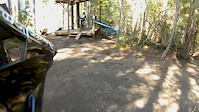
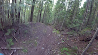
Photos of Rubberhead Trail System Mountain Bike
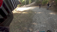
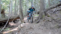
Videos of Rubberhead Trail System Mountain Bike
trail: Upper Meatgrinder
2:34 |
2930 |
Nov 21, 2021
trail: Ravine (7km)
4:39 |
243 |
Sep 21, 2018
trail: Muffin Top
2:20 |
274 |
Apr 27, 2018
trail: Rubberhead (Climb)
0:47 |
353 |
Jul 1, 2016
trail: Veggie Delight
2:14 |
243 |
Apr 17, 2016
trail: Rubberhead (Climb)
0:55 |
1016 |
May 31, 2015
trail: Veggie Delight
2:52 |
178 |
Apr 27, 2015
trail: Veggie Delight
2:09 |
133 |
Apr 27, 2015
Recent Trail Reports
| status | trail | date | condition | info | user |
|---|---|---|---|---|---|
| Veggie Delight | Jun 26, 2026 @ 5:25am (America/Vancouver) Jun 26, 2026 | Unknown | a-zircon | ||
| Double D (upper) | Jun 25, 2026 @ 3:49pm (America/Creston) Jun 25, 2026 | Dry | canadaka Trailforks | ||
| Alvin’s Greatest Hits | Jun 25, 2026 @ 3:49pm (America/Creston) Jun 25, 2026 | Very Dry | canadaka Trailforks | ||
| Alvin Comes Alive | Jun 25, 2026 @ 3:49pm (America/Creston) Jun 25, 2026 | Dry | canadaka Trailforks | ||
| Sea Doo | Jun 25, 2026 @ 3:49pm (America/Creston) Jun 25, 2026 | Very Dry | canadaka Trailforks | ||
| A-Frame | Jun 25, 2026 @ 3:49pm (America/Creston) Jun 25, 2026 | Very Dry | canadaka Trailforks | ||
| Lower Meat Grinder | Jun 25, 2026 @ 3:49pm (America/Creston) Jun 25, 2026 | Very Dry | canadaka Trailforks | ||
| Upper Meatgrinder | Jun 25, 2026 @ 3:49pm (America/Creston) Jun 25, 2026 | Very Dry | canadaka Trailforks | ||
| Muffin Top | Jun 25, 2026 @ 3:49pm (America/Creston) Jun 25, 2026 | Dry | canadaka Trailforks | ||
| Half Baked | Jun 25, 2026 @ 3:49pm (America/Creston) Jun 25, 2026 | Dry | canadaka Trailforks |
Activity Feed
| username | action | type | title | date |
|---|---|---|---|---|
| JoeDick | comment | report | activity #97861479 | Jun 26, 2026 @ 3:42pm 3 days |
| a-zircon | add | report | activity #97827325 | Jun 26, 2026 @ 5:25am Jun 26, 2026 |
| canadaka | add | report | activity #97814871 and 14 more | Jun 25, 2026 @ 9:35pm Jun 25, 2026 |
| thodder | comment | trail | activity #97735043 and 1 more | Jun 24, 2026 @ 5:17pm Jun 24, 2026 |
| thodder | ridden | trail | activity #97734906 and 1 more | Jun 24, 2026 @ 5:15pm Jun 24, 2026 |
Recent Comments
| username | type | title | comment | date |
|---|---|---|---|---|
| report | fixed today | Jun 26, 2026 @ 3:42pm 3 days | ||
| trail | A very fun trail that needs some maintenance... | Jun 24, 2026 @ 5:20pm Jun 24, 2026 | ||
| trail | It’s a slog up to the end of the road on an... | Jun 24, 2026 @ 5:17pm Jun 24, 2026 | ||
| trail | Decent more tech trail. No features. | Jun 19, 2026 @ 7:13pm Jun 19, 2026 | ||
| trail | The flowiest trail around. way better than... | Jun 19, 2026 @ 7:13pm Jun 19, 2026 |
Nearby Areas
| name | distance | ||||
|---|---|---|---|---|---|
| Reinecker Creek Trail System | 6 | 1.8 km | |||
| Park Hill | 29 | 5 | 2.7 km | ||
| Larch Hills Nordic Trails | 6 | 5 | 2 | 4.1 km | |
| Larch Hills Traverse | 8 | 4.1 km | |||
| Coyote Park | 8 | 5 | 4.2 km |
Local Badges
-

Completionist0 awarded
Activity Type Stats
| activitytype | trails | distance | descent | descent distance | total vertical | rating | global rank | state rank | photos | reports | routes | ridelogs |
|---|---|---|---|---|---|---|---|---|---|---|---|---|
| Mountain Bike | 38 | 32 miles | 8,658 ft | 15 miles | 3,018 ft | #1,679 | #113 | 290 | 956 | 8 | 4,729 | |
| E-Bike | 38 | 32 miles | 8,363 ft | 15 miles | 3,018 ft | #3,006 | #104 | 8 | 902 | 1 | 208 | |
| Gravel Bike | 1 | #800 | #95 | 2 | 4 | |||||||
| Horse | 2 | 5 miles | 348 ft | 2 miles | 804 ft | #1,128 | #37 | 251 | 1 | |||
| Hike | 35 | 31 miles | 8,064 ft | 14 miles | 3,018 ft | #2,761 | #121 | 13 | 932 | 41 | ||
| Trail Running | 34 | 31 miles | 7,769 ft | 14 miles | 3,018 ft | #4,650 | #158 | 929 | 34 | |||
| Dirtbike/Moto | 2 | 5 miles | 348 ft | 2 miles | 804 ft | #523 | #56 | 251 | 9 | |||
| Observed Trials | 1 | |||||||||||
| ATV/ORV/OHV | 2 | 5 miles | 348 ft | 2 miles | 804 ft | #358 | #31 | 251 | 3 | |||
| Snowmobile | 1 | 1 | ||||||||||
| Snowshoe | 2 | 1 mile | 46 ft | 712 ft | 528 ft | 27 | 11 | |||||
| Downhill Ski | 1 | |||||||||||
| Backcountry Ski | 1 | |||||||||||
| Nordic Ski | 2 | 5 miles | 348 ft | 2 miles | 804 ft |
Frequently Asked Questions About Rubberhead Trail System
▼
What are the highest rated mountain biking trails in Rubberhead Trail System?
The highest rated mountain biking trails in Rubberhead Trail System are:
- Ravine (6.5km) (4.4/5)
- Ravine (4.4/5)
- Mourning Wood (4.3/5)
- Double D (4.3/5)
- Ravine (9km) (4.3/5)
▼
What is the best time of the year to ride in Rubberhead Trail System?
Based on ride log data, the most popular months to ride in Rubberhead Trail System are:
- July (164 activities)
- May (111 activities)
- June (99 activities)
▼
Where can I park to ride in Rubberhead Trail System?
There are 3 parking locations listed in Rubberhead Trail System. The most popular parking spots are: View all parking and trailhead locations on the map to plan your visit.
▼
What is the longest trail in Rubberhead Trail System?
The longest trail in Rubberhead Trail System is Ravine at 1.4 miles. View all trails sorted by distance.
Activities
Trails
- Hard trails in Rubberhead Trail System
- Easy trails in Rubberhead Trail System
- Favorite trails in Rubberhead Trail System
- Most ridden trails in Rubberhead Trail System
- Singletrack in Rubberhead Trail System
- Viewpoint trails in Rubberhead Trail System
- Trails with technical features in Rubberhead Trail System
- Race routes in Rubberhead Trail System
- By canadaka
 Trailforks & contributors
 - Admins: STAB, SCC
- #1919 - 25,988 views
- rubberhead trail system activity log | embed map of Rubberhead Trail System mountain bike trails | rubberhead trail system mountain biking points of interest
Downloading of trail gps tracks in kml & gpx formats is enabled for Rubberhead Trail System.
You must login to download files.