close
-
Layers w
- Weather Layers
- Pro
- Pro
- Pro
- Pro
- Pro
- Pro
- More Layers
- Pro
- Pro
- Pro
- Pro
-
Upgrade to

3D
Trail Conditions
- Unknown
- Snow Groomed
- Snow Packed
- Snow Covered
- Snow Cover Partial
- Freeze/thaw Cycle
- Icy
- Prevalent Mud
- Wet
- Variable
- Ideal
- Dry
- Very Dry
Trail Flow (Ridden Direction)
Trailforks scans users ridelogs to determine the most popular direction each trail is ridden. A good flowing trail network will have most trails flowing in a single direction according to their intension.
The colour categories are based on what percentage of riders are riding a trail in its intended direction.
The colour categories are based on what percentage of riders are riding a trail in its intended direction.
- > 96%
- > 90%
- > 80%
- > 70%
- > 50%
- < 50%
- bi-directional trail
- no data
Trail Last Ridden
Trailforks scans ridelogs to determine the last time a trail was ridden.
- < 2 days
- < 1 week
- < 2 weeks
- < 1 month
- < 6 months
- > 6 months
Trail Ridden Direction
The intended direction a trail should be ridden.
- Downhill Only
- Downhill Primary
- Both Directions
- Uphill Primary
- Uphill Only
- One Direction
Contribute Details
Colors indicate trail is missing specified detail.
- Description
- Photos
- Description & Photos
- Videos
Trail Popularity ?
Trailforks scans ridelogs to determine which trails are ridden the most in the last 9 months.
Trails are compared with nearby trails in the same city region with a possible 25 colour shades.
Think of this as a heatmap, more rides = more kinetic energy = warmer colors.
- most popular
- popular
- less popular
- not popular
ATV/ORV/OHV Filter
Max Vehicle Width
inches
US Cell Coverage
Legend

Radar Time
Activity Recordings
Trailforks uses anonymized public activity data.
?
Activity Recordings
Trailforks uses anonymized public activity data.
?
Personal Heatmap
▶
Activity Types
all
/
none
▶
Options
2
Date range
month
–
Winter Trails
Warning
A routing network for winter maps does not exist. Selecting trails using the winter trails layer has been disabled.
Missing Trails
Most Popular
Least Popular
Trails are colored based on popularity. The more popular a trail is, the more red. Less popular trails trend towards green.
Jump Magnitude Heatmap
Heatmap of where riders jump on trails. Zoom in to see individual jumps, click circles to view jump details.
BC Backroad Status
![map legend]()
Service Road Atlas is a free to use, community-driven service for viewing and creating reports on the numerous back-country service roads around B.C. and Alberta.

Slope Aspect
Direction the slope faces
Trails Deemphasized
Trails are shown in grey.
Only show trails with no bike usage.
Suggested Layers
Based on selected activity type
Save the current map location and zoom level as your default home location whenever this page is loaded.
Save
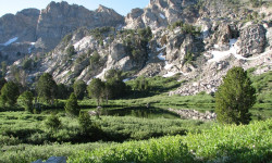
No description for Ruby Valley has been added yet!
Login or register to submit one.
Activities Click to view
- Mountain Bike
6 trails
- E-Bike
0 trails
- Horse
10 trails
- Hike
26 trails
- Trail Running
18 trails
- Dirtbike/Moto
0 trails
- ATV/ORV/OHV
0 trails
- Snowmobile
0 trails
- Snowshoe
0 trails
Region Details
- 5
- 1
Region Status
Open as of Nov 10, 2023Stats
- Trails (view details)
- 26
- Trails Mountain Bike
- 6
- Trails Horse
- 10
- Trails Hike
- 26
- Trails Trail Running
- 18
- Total Distance
- 69 miles
- Total Descent Distance
- 23 miles
- Total Descent
- 11,623 ft
- Total Vertical
- 4,798 ft
- Highest Trailhead
- 10,764 ft
- Ridden Counter
- 46
Articles
Elko, NV: Ruby Crest National Recreation Trail
Sep 19, 2013 from backpacker.com
Dazzling high-country lakes, glacier-carved cirques and miles of stunning alpine scenery render this secluded 38-mile National Recreation Trail a...
Sub Regions
-
Ruby Lake National Wildlife Refuge
- 1
Popular Ruby Valley Mountain Biking Trails
• 5 ★ 0.0 • 2,060 ft • 0 ft • • hike
Less popular white difficulty singletrack. This hike primary trail can be used both directions.
Activity Feed
| username | action | type | title | date |
|---|---|---|---|---|
| chuktA | add | trail | activity #39900876 and 1 more | May 12, 2023 @ 8:33am May 12, 2023 |
Local Badges
-

Epic Ride Descent 2k0 awarded -

Descent 10k Badge0 awarded -

Descent 100k Badge0 awarded
Activity Type Stats
| activitytype | trails | distance | descent | descent distance | total vertical | rating | global rank | state rank | photos | reports | routes | ridelogs |
|---|---|---|---|---|---|---|---|---|---|---|---|---|
| Mountain Bike | 6 | 14 miles | 144 ft | 5,138 ft | 2,867 ft | #13,427 | #4,085 | 21 | ||||
| Horse | 10 | 45 miles | 11,460 ft | 22 miles | 4,626 ft | #1,288 | #790 | |||||
| Hike | 26 | 69 miles | 11,624 ft | 23 miles | 4,797 ft | #3,837 | #1,359 | 56 | ||||
| Trail Running | 18 | 65 miles | 10,899 ft | 22 miles | 4,797 ft | #3,959 | #1,189 | 7 |
Frequently Asked Questions About Ruby Valley
▼
What are the best places to ride in Ruby Valley?
Ruby Valley has 2 areas to explore for mountain biking. The top rated areas are:
▼
What are the highest rated mountain biking trails in Ruby Valley?
The highest rated mountain biking trails in Ruby Valley are:
- NW Dike (0/5)
▼
Where can I park to ride in Ruby Valley?
There are 5 parking locations listed in Ruby Valley. The most popular parking spots are:
- Visitor Center
- Bressman Access
- Brown Dike Access
- Collection Ditch Trailhead (Fingers Access)
- Ringneck Pond Access
▼
What is the longest trail in Ruby Valley?
The longest trail in Ruby Valley is NW Dike at 2,060 ft. View all trails sorted by distance.
Activities
Trails
Points of Interest
- By chuktA
 TRAILFORKS NFTA & contributors
 - Admins: apply
- #57719 - 1,531 views
- ruby valley activity log | embed map of Ruby Valley mountain bike trails | ruby valley mountain biking points of interest
Downloading of trail gps tracks in kml & gpx formats is enabled for Ruby Valley.
You must login to download files.